Radiating regional roads
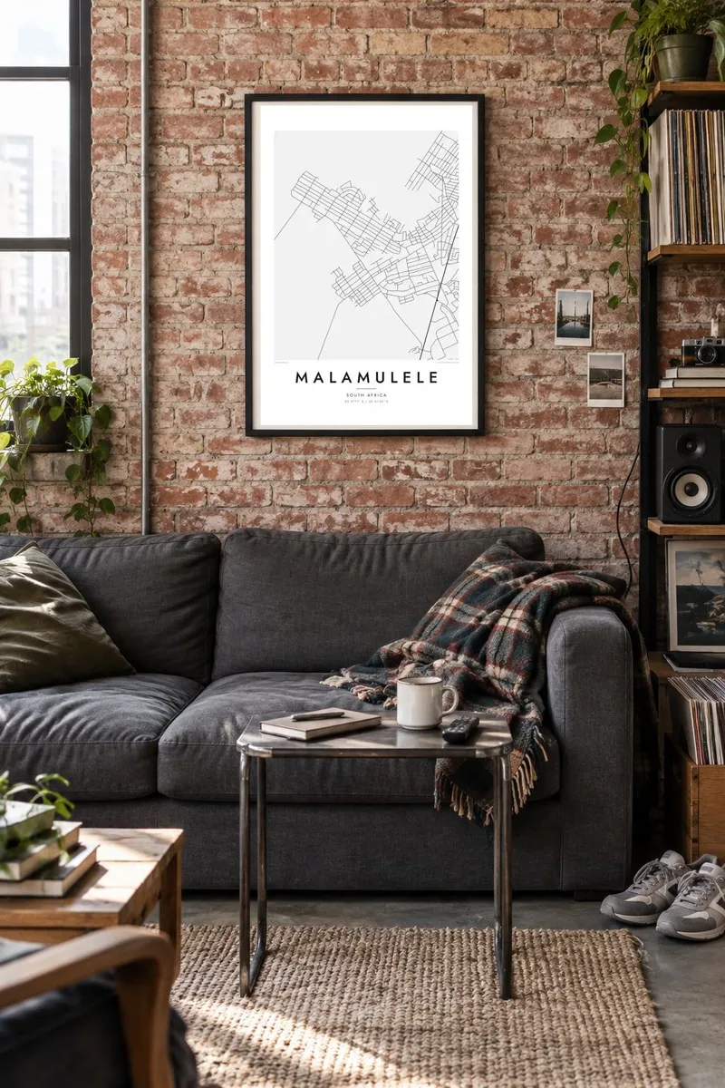
Several routes meet at Malamulele and head off toward neighbouring villages and towns. On the poster they form a clear star pattern that anchors the whole design.
Pōhita mape faigofie · South Africa
22.9711° S / 30.6736° E
A spread-out Limpopo town whose roads fan out across the bushveld toward surrounding villages and the edge of Kruger country.

Taone e tahi, lagona e lima
Pa'i se ata ke va'ai ai i luga o te pā. E tutusa te tau o ata uma — i lomiga, fakapipi'i i faleata, pe ko faila HD.
 Pixels mo'i · Faila lomiga 24 × 36″
Manino mo te lomiga
Ko se kupega 100% mai te faila lomiga mo'i. Poster uma — pe lomiina, fakapipi'i i faleata, pe download-ina — e fakaatagia i luga o a matou setula i te 300 DPI, e oo atu ki te 7,200 × 10,800 pixels, ina ia mautinoa e ma'ai pea auala tuai foki i luga o se lomiga 24 × 36″.
I luga o te pa


Te mape
Malamulele lies in the far north-east of South Africa's Limpopo province, in lowveld country not far from the western boundary of Kruger National Park. From above it looks nothing like a tight grid. It is a loose, wide settlement where a central commercial area gives way to residential sections and then to villages scattered along the roads that cross the bushveld.
The town is a centre for the Xitsonga-speaking communities of the area. It is known for the local campaign that led to a municipality of its own: in 2016 it became part of the newly formed Collins Chabane Local Municipality. That civic role shows on the map in the roads, which lead to Malamulele from many directions.
A Malamulele map poster shows how that pattern holds together. Clusters of small plots, winding local roads and long regional routes fill the frame with fine texture. Dry riverbeds and open veld add gentle breaks between them. The result is a map of a place that grows outward rather than upward, and it still reads clearly from a distance.
Several routes meet at Malamulele and head off toward neighbouring villages and towns. On the poster they form a clear star pattern that anchors the whole design.
Around the centre, residential sections and nearby villages appear as patches of small plots and lanes. They spread the detail widely across the frame instead of packing it into one core.
Stretches of bush and farmland lie between the settlements and turn into calm white space. That space sets off the finer lines of the streets.
Fai mo koe
Fakaopoopo he aho, he igoa pe he upu a koe, hui te faiga, te lahi pe te tūlaga.
Ko te va'aiga e leai se totogi e maualalo tona resolution ma iai se fakailoga vai. E fakaatagia lomiga ma faila HD i te 300 DPI, e oo atu ki te 7,200 × 10,800 px, e aunoa ma se fakailoga vai.
Aiheā Malamulele
The map suits anyone with roots in Malamulele or the villages around it, and anyone who has passed through on the way to the northern part of Kruger. It records a place defined by its connections, where each road leads to somebody's home.
The title, subtitle and coordinates line can be personalised with a village name, a family surname or an important date. There are five styles to choose from: Classic black & white, Noir, Paper, Blueprint and Sand. Warmer tones such as Sand suit the lowveld setting well.
Oka te poster Malamulele| Lahi o te lomiga | Manino | Faila |
|---|---|---|
| 30 × 40 cm11.8 × 15.7″ | 3,543 × 4,724 px | PNG · PDF |
| 29.7 × 42 cm (A3)11.7 × 16.5″ | 3,508 × 4,961 px | PNG · PDF |
| 42 × 59.4 cm (A2)16.5 × 23.4″ | 4,961 × 7,016 px | PNG · PDF |
| 45.7 × 61 cm18 × 24″ | 5,400 × 7,200 px | PNG · PDF |
| 50 × 70 cm19.7 × 27.6″ | 5,906 × 8,268 px | PNG · PDF |
| 61 × 91.4 cm24 × 36″ | 7,200 × 10,800 px | PNG · PDF |
Mo te fakatatau, ko te fakaakoakoga e hē totogi e 900 px te lautele, e ihi te fakailoga ma mo te lau komipiuta. Ko nā faila HD e oko ki te 8× te manino i itū taki tahi ma e lomia lelei i te lahi kātoa o te pōhita.
Filifili se ata i te pito i luga o te itulau, ona filifili lea o te Poster Lomiina — se lapoa ma, ka manako ai koe, se faleata — pe ko Faila HD Fakaonaonaina. E tasi te laasaga o te ōkaina, ma ka fakafou loa lau itulau ōkaina pe a mae'a te totogi.
E lomiina i luga o se pepa matte kaliki maualuga e 200 gsm, i se tasi o ni lapoa e ono, mai le 30 × 40 cm ki te 24 × 36″. E kamata te tau o poster lomiina mai le $39, aofia ai te uta.
Ioe. Filifili se faleata lakau malō i te lanu uli, tea, oki masani pe lakau pouli. E aumai fakatasi mo se tioata e le gagamu ma ua sauni ke tautau. E kamata te tau o poster fakapipi'i i se faleata mai le $99, aofia ai te uta.
E tuku uma te uta ki fenua e 60+. Ko te pepa takitasi e lomi e te tasi o a matou paaga lomi i fenua e 30+, ka tae mai i aso galue e 3–7. E mafai ke e maimoa ki te tulaga mo te tulitaki i lalo o Taku Fakatonuga. E lauiti nei fenua e 2–5 wiki, ka ko nei fenua e le o tuku atu ai, e fakamatala atu e te weepisi i mua o te totogi.
Auina mai se ata pikitia i loto o te 14 aso mai te taimi na oo mai ai, ka toe lomiina e matou e leai se totogi pe toe totogi atu lau tupe.
Ioe. I te mea fakasa'o i luga o lenei itulau, sui te ulutala, te ulutala lalo ma te laina fakamaoniga tulaga ki so se mea e manako ai koe, ona filifili lea o se ata ma se lapoa. Okaina lomiina, fakapipi'i i faleata, ma fakaonaonaina e fakaaogā uma i tau ata tonu.
Mo le $9 e maua e koe ni faila PNG 300 DPI ma PDF sauni-mo-lomiga i lapoa e ono uma, e aunoa ma se fakailoga vai, ke lomiina i so se mea. E le'i mautinoa? Download muamua se va'aiga fakailoga vai e leai se totogi.
