The crater harbour
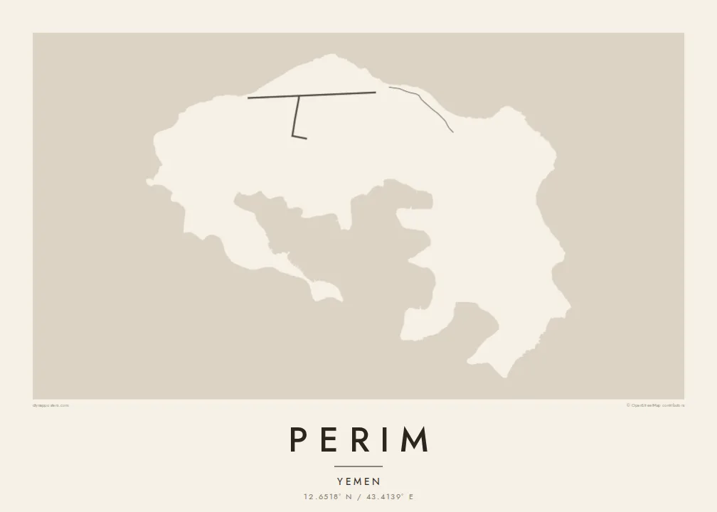
The island's core is a sheltered bay enclosed by curving arms of land, the flooded heart of an old volcano. It gives Perim its unmistakable horseshoe outline on the map.
Pōhita mape faigofie · Yemen
12.6518° N / 43.4139° E
A small volcanic horseshoe in the Bab-el-Mandeb strait, curled around a sheltered natural harbour.




Taone e tahi, lagona e lima
Pa'i se ata ke va'ai ai i luga o te pā. E tutusa te tau o ata uma — i lomiga, fakapipi'i i faleata, pe ko faila HD.
 Pixels mo'i · Faila lomiga 24 × 36″
Manino mo te lomiga
Ko se kupega 100% mai te faila lomiga mo'i. Poster uma — pe lomiina, fakapipi'i i faleata, pe download-ina — e fakaatagia i luga o a matou setula i te 300 DPI, e oo atu ki te 7,200 × 10,800 pixels, ina ia mautinoa e ma'ai pea auala tuai foki i luga o se lomiga 24 × 36″.
I luga o te pa


Te mape
Perim is a small island in the Bab-el-Mandeb, the strait that joins the Red Sea to the Gulf of Aden. It lies close to the Yemeni coast, in the narrow channel between Arabia and Africa. Its shape is the first thing you notice. The island is the remains of a volcanic crater, curled into a rough horseshoe around a deep, enclosed bay.
That natural harbour and the island's position on one of the world's busiest sea lanes gave Perim an outsized role in the past. In the late nineteenth and early twentieth centuries, the British used it as a coaling station for ships travelling between the Suez Canal and the Indian Ocean. Today it is sparsely inhabited, and it is known in Arabic as Mayun.
A Perim map poster is almost entirely about the coastline. The curved arms of the island wrap around the inner bay, and there is only a light scatter of lines on the land itself. Open water frames the island on all sides. The result is a spare, graphic shape that is easy to recognise at any size.
The island's core is a sheltered bay enclosed by curving arms of land, the flooded heart of an old volcano. It gives Perim its unmistakable horseshoe outline on the map.
Perim sits in the Bab-el-Mandeb, between the Arabian Peninsula and the Horn of Africa. At a wider framing, the poster shows the island guarding the narrow passage.
There are very few roads or buildings on the island. That leaves the land mostly blank, so the outline and inner harbour carry the entire composition.
Fai mo koe
Fakaopoopo he aho, he igoa pe he upu a koe, hui te faiga, te lahi pe te tūlaga.
Ko te va'aiga e leai se totogi e maualalo tona resolution ma iai se fakailoga vai. E fakaatagia lomiga ma faila HD i te 300 DPI, e oo atu ki te 7,200 × 10,800 px, e aunoa ma se fakailoga vai.
Aiheā Perim
Perim appeals to people drawn to maritime history, shipping routes and unusual geography. Its horseshoe shape is striking on its own, even for those who have never been there. It suits a study or office wall as a clean, almost abstract form with a real story behind it.
Add a title of your choosing, a subtitle and your own coordinates line, then pick from Classic black & white, Noir, Paper, Blueprint or Sand. The $9 digital download includes six sizes at 300 DPI with no watermark. Printed posters ship from partners in more than 30 countries.
Oka te poster Perim| Lahi o te lomiga | Manino | Faila |
|---|---|---|
| 30 × 40 cm (11.8 × 15.7″) | 3,543 × 4,724 px | PNG · PDF |
| 29.7 × 42 cm (A3, 11.7 × 16.5″) | 3,508 × 4,961 px | PNG · PDF |
| 42 × 59.4 cm (A2, 16.5 × 23.4″) | 4,961 × 7,016 px | PNG · PDF |
| 45.7 × 61 cm (18 × 24″) | 5,400 × 7,200 px | PNG · PDF |
| 50 × 70 cm (19.7 × 27.6″) | 5,906 × 8,268 px | PNG · PDF |
| 61 × 91.4 cm (24 × 36″) | 7,200 × 10,800 px | PNG · PDF |
Mo te fakatatau, ko te fakaakoakoga e hē totogi e 900 px te lautele, e ihi te fakailoga ma mo te lau komipiuta. Ko nā faila HD e oko ki te 8× te manino i itū taki tahi ma e lomia lelei i te lahi kātoa o te pōhita.
Filifili se ata i te pito i luga o te itulau, ona filifili lea o te Poster Lomiina — se lapoa ma, ka manako ai koe, se faleata — pe ko Faila HD Fakaonaonaina. E tasi te laasaga o te ōkaina, ma ka fakafou loa lau itulau ōkaina pe a mae'a te totogi.
E lomiina i luga o se pepa matte kaliki maualuga e 200 gsm, i se tasi o ni lapoa e ono, mai le 30 × 40 cm ki te 24 × 36″. E kamata te tau o poster lomiina mai le {printFrom}, aofia ai te uta.
Ioe. Filifili se faleata lakau malō i te lanu uli, tea, oki masani pe lakau pouli. E aumai fakatasi mo se tioata e le gagamu ma ua sauni ke tautau. E kamata te tau o poster fakapipi'i i se faleata mai le {framedFrom}, aofia ai te uta.
E leai se totogi o te ave i te lalolagi katoa. Ko te pepa ata taki tasi e lomi e te hoa lomi e latalata mai ki a matou i atunuku e 30+, ma e masani ona aulia i aso galuega e 3–7. E mafai ke e mulimuli i te tulaga ma te ala o tau poloaiga i lalo o Aku Poloaiga. E nai atunuku e 2–5 vaiaso te umi, ma i te mea e le i ave ai matou, e fakailoa atu e te initeneti a e le i totogi koe.
Auina mai se ata pikitia i loto o te 14 aso mai te taimi na oo mai ai, ka toe lomiina e matou e leai se totogi pe toe totogi atu lau tupe.
Ioe. I te mea fakasa'o i luga o lenei itulau, sui te ulutala, te ulutala lalo ma te laina fakamaoniga tulaga ki so se mea e manako ai koe, ona filifili lea o se ata ma se lapoa. Okaina lomiina, fakapipi'i i faleata, ma fakaonaonaina e fakaaogā uma i tau ata tonu.
Mo le $9 e maua e koe ni faila PNG 300 DPI ma PDF sauni-mo-lomiga i lapoa e ono uma, e aunoa ma se fakailoga vai, ke lomiina i so se mea. E le'i mautinoa? Download muamua se va'aiga fakailoga vai e leai se totogi.
Latalata
