Confluence of rivers
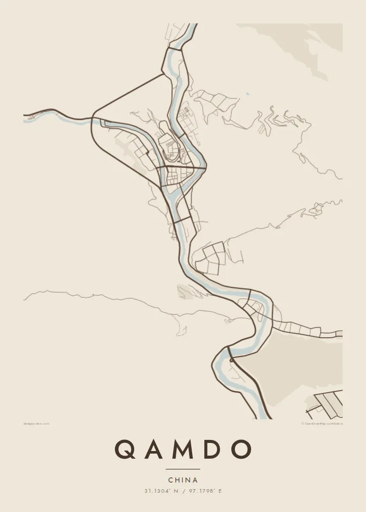
The Dza Chu and Ngom Chu meet at the heart of the town. Their joined channel heads south as the Lancang, and the fork gives the map its clear Y-shaped outline.
Pōhita mape faigofie · China
31.1304° N / 97.1798° E
A narrow wedge of streets where two mountain rivers meet and join to form the upper Mekong, walled in by steep slopes


Taone e tahi, lagona e lima
Pa'i se ata ke va'ai ai i luga o te pā. E tutusa te tau o ata uma — i lomiga, fakapipi'i i faleata, pe ko faila HD.
 Pixels mo'i · Faila lomiga 24 × 36″
Manino mo te lomiga
Ko se kupega 100% mai te faila lomiga mo'i. Poster uma — pe lomiina, fakapipi'i i faleata, pe download-ina — e fakaatagia i luga o a matou setula i te 300 DPI, e oo atu ki te 7,200 × 10,800 pixels, ina ia mautinoa e ma'ai pea auala tuai foki i luga o se lomiga 24 × 36″.
I luga o te pa


Te mape
Seen from above, Qamdo sits on a point of land in eastern Tibet, at the spot where two rivers, the Dza Chu and the Ngom Chu, flow together. Below the junction they carry on as the Lancang, the name the upper Mekong takes in China. The town fills the flat ground at the confluence and follows both valleys upstream, so its street plan looks like a letter Y cut into the mountains.
The terrain sets the shape of the city more than any plan does. The valley floors are narrow, and the slopes rise sharply on every side, so buildings line the riverbanks in long bands and the roads bend with the water. Bridges link the neighbourhoods on the far banks back to the central point. On a Qamdo map poster the rivers stay in clear view, and the blank hillsides around them read as open space.
Qamdo has long been one of the main towns of the Kham region and a stop on the old routes between Tibet and Sichuan and Yunnan. On a terrace above the confluence stands Qamdo Monastery, a large Gelug monastery founded in the fifteenth century, which still shapes the skyline. The town lies at roughly 3,200 metres, and that height matters in every valley and slope you see on the map.
The Dza Chu and Ngom Chu meet at the heart of the town. Their joined channel heads south as the Lancang, and the fork gives the map its clear Y-shaped outline.
Qamdo Monastery sits on raised ground between the two rivers, above the central streets. Its large compound shows up on the map as a distinct block at the top of the confluence.
Steep slopes hem the town in, so its roads run in long, curving lines beside the rivers. Bridges cross the water at intervals and tie the separate banks into one town.
Fai mo koe
Fakaopoopo he aho, he igoa pe he upu a koe, hui te faiga, te lahi pe te tūlaga.
Ko te va'aiga e leai se totogi e maualalo tona resolution ma iai se fakailoga vai. E fakaatagia lomiga ma faila HD i te 300 DPI, e oo atu ki te 7,200 × 10,800 px, e aunoa ma se fakailoga vai.
Aiheā Qamdo
Qamdo appeals to people who have made the long overland journey through Kham, or to anyone who grew up in these valleys. Where rivers meet in the mountains, the map has a strong outline, and in black and white it reads almost like a drawing of how the water runs.
You can personalise the poster with your own title, subtitle and coordinates line, perhaps the date you crossed a pass or first reached the town. Choose from five styles: Classic black & white, Noir, Paper, Blueprint or Sand. Get HD files for $9, or order a matte print with an optional wooden frame.
Oka te poster Qamdo| Lahi o te lomiga | Manino | Faila |
|---|---|---|
| 30 × 40 cm (11.8 × 15.7″) | 3,543 × 4,724 px | PNG · PDF |
| 29.7 × 42 cm (A3, 11.7 × 16.5″) | 3,508 × 4,961 px | PNG · PDF |
| 42 × 59.4 cm (A2, 16.5 × 23.4″) | 4,961 × 7,016 px | PNG · PDF |
| 45.7 × 61 cm (18 × 24″) | 5,400 × 7,200 px | PNG · PDF |
| 50 × 70 cm (19.7 × 27.6″) | 5,906 × 8,268 px | PNG · PDF |
| 61 × 91.4 cm (24 × 36″) | 7,200 × 10,800 px | PNG · PDF |
Mo te fakatatau, ko te fakaakoakoga e hē totogi e 900 px te lautele, e ihi te fakailoga ma mo te lau komipiuta. Ko nā faila HD e oko ki te 8× te manino i itū taki tahi ma e lomia lelei i te lahi kātoa o te pōhita.
Filifili se ata i te pito i luga o te itulau, ona filifili lea o te Poster Lomiina — se lapoa ma, ka manako ai koe, se faleata — pe ko Faila HD Fakaonaonaina. E tasi te laasaga o te ōkaina, ma ka fakafou loa lau itulau ōkaina pe a mae'a te totogi.
E lomiina i luga o se pepa matte kaliki maualuga e 200 gsm, i se tasi o ni lapoa e ono, mai le 30 × 40 cm ki te 24 × 36″. E kamata te tau o poster lomiina mai le {printFrom}, aofia ai te uta.
Ioe. Filifili se faleata lakau malō i te lanu uli, tea, oki masani pe lakau pouli. E aumai fakatasi mo se tioata e le gagamu ma ua sauni ke tautau. E kamata te tau o poster fakapipi'i i se faleata mai le {framedFrom}, aofia ai te uta.
E fua noa te uta i te lalolagi katoa. Poster ta'itasi e lomiina e te pāketiha lomiga pili mai i lo matou 30+ atunu'u, ma e masani ona oo mai i loto i te 3–7 aso gāluega. E mafai ona ke va'aiina te tulaga o lau okaina i lalo ifo o My Orders.
Auina mai se ata pikitia i loto o te 14 aso mai te taimi na oo mai ai, ka toe lomiina e matou e leai se totogi pe toe totogi atu lau tupe.
Ioe. I te mea fakasa'o i luga o lenei itulau, sui te ulutala, te ulutala lalo ma te laina fakamaoniga tulaga ki so se mea e manako ai koe, ona filifili lea o se ata ma se lapoa. Okaina lomiina, fakapipi'i i faleata, ma fakaonaonaina e fakaaogā uma i tau ata tonu.
Mo le $9 e maua e koe ni faila PNG 300 DPI ma PDF sauni-mo-lomiga i lapoa e ono uma, e aunoa ma se fakailoga vai, ke lomiina i so se mea. E le'i mautinoa? Download muamua se va'aiga fakailoga vai e leai se totogi.
