Ajinkyatara fort hill
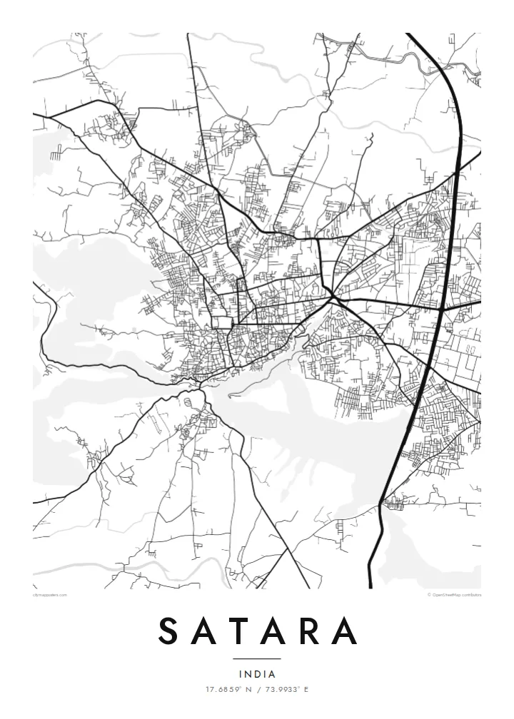
The fort's plateau rises right beside the town. On the map the streets thin out and bend around its slopes, leaving a clear open shape that anchors the whole composition.
Pōhita mape faigofie · India
17.6859° N / 73.9933° E
A hill-ringed Deccan town between the Krishna and Venna rivers, with a fort ridge rising directly above its streets


Taone e tahi, lagona e lima
Pa'i se ata ke va'ai ai i luga o te pā. E tutusa te tau o ata uma — i lomiga, fakapipi'i i faleata, pe ko faila HD.
 Pixels mo'i · Faila lomiga 24 × 36″
Manino mo te lomiga
Ko se kupega 100% mai te faila lomiga mo'i. Poster uma — pe lomiina, fakapipi'i i faleata, pe download-ina — e fakaatagia i luga o a matou setula i te 300 DPI, e oo atu ki te 7,200 × 10,800 pixels, ina ia mautinoa e ma'ai pea auala tuai foki i luga o se lomiga 24 × 36″.
I luga o te pa


Te mape
Satara sits in a bowl of the Western Ghats foothills, close to where the Venna joins the Krishna. From above, the town spreads across fairly level ground and stops where the slopes begin, so the edges of its street network follow the contours of the hills around it. Ajinkyatara, the fort that overlooks the city, shows on the map as a flat-topped ridge pressing against the edge of town.
Satara matters in Maratha history. In the eighteenth century it was the seat of the Chhatrapati line descended from Shivaji. The older quarters still have the dense, irregular lanes of a courtly town rather than a planned grid. Newer neighbourhoods and the main highway corridor spread outward in straighter lines, so the map has two distinct textures side by side.
A Satara map poster also has room for the landscape beyond the town. To the west, the Kaas plateau, known for the wildflowers that cover it after the monsoon, sits high on the escarpment, and roads climb toward it in tight switchbacks. Drawn in fine black lines, the river, the fort hill and the winding ghat roads make a composition that is clearly tied to its terrain.
The fort's plateau rises right beside the town. On the map the streets thin out and bend around its slopes, leaving a clear open shape that anchors the whole composition.
Two rivers meet near the city. Their curving channels add soft, organic lines to the map, a counterpoint to the compact and busy street pattern of the town itself.
Roads heading west toward the Sahyadri escarpment fold into tight hairpins as they climb, a pattern that reads almost like handwriting when printed in thin black line.
Fai mo koe
Fakaopoopo he aho, he igoa pe he upu a koe, hui te faiga, te lahi pe te tūlaga.
Ko te va'aiga e leai se totogi e maualalo tona resolution ma iai se fakailoga vai. E fakaatagia lomiga ma faila HD i te 300 DPI, e oo atu ki te 7,200 × 10,800 px, e aunoa ma se fakailoga vai.
Aiheā Satara
For people from Satara, and for those who have passed through on the way to the Kaas plateau or Mahabaleshwar, this map shows a familiar geography of fort, river and hills. It works as a quiet reminder of home, of student years, or of a monsoon trek.
You can set your own title, subtitle and coordinates line, adding a family name or a date, and choose from five styles: Classic black & white, Noir, Paper, Blueprint or Sand. You can download HD files for $9 or order a matte print with an optional wooden frame.
Oka te poster Satara| Lahi o te lomiga | Manino | Faila |
|---|---|---|
| 30 × 40 cm (11.8 × 15.7″) | 3,543 × 4,724 px | PNG · PDF |
| 29.7 × 42 cm (A3, 11.7 × 16.5″) | 3,508 × 4,961 px | PNG · PDF |
| 42 × 59.4 cm (A2, 16.5 × 23.4″) | 4,961 × 7,016 px | PNG · PDF |
| 45.7 × 61 cm (18 × 24″) | 5,400 × 7,200 px | PNG · PDF |
| 50 × 70 cm (19.7 × 27.6″) | 5,906 × 8,268 px | PNG · PDF |
| 61 × 91.4 cm (24 × 36″) | 7,200 × 10,800 px | PNG · PDF |
Mo te fakatatau, ko te fakaakoakoga e hē totogi e 900 px te lautele, e ihi te fakailoga ma mo te lau komipiuta. Ko nā faila HD e oko ki te 8× te manino i itū taki tahi ma e lomia lelei i te lahi kātoa o te pōhita.
Filifili se ata i te pito i luga o te itulau, ona filifili lea o te Poster Lomiina — se lapoa ma, ka manako ai koe, se faleata — pe ko Faila HD Fakaonaonaina. E tasi te laasaga o te ōkaina, ma ka fakafou loa lau itulau ōkaina pe a mae'a te totogi.
E lomiina i luga o se pepa matte kaliki maualuga e 200 gsm, i se tasi o ni lapoa e ono, mai le 30 × 40 cm ki te 24 × 36″. E kamata te tau o poster lomiina mai le $39, aofia ai te uta.
Ioe. Filifili se faleata lakau malō i te lanu uli, tea, oki masani pe lakau pouli. E aumai fakatasi mo se tioata e le gagamu ma ua sauni ke tautau. E kamata te tau o poster fakapipi'i i se faleata mai le $99, aofia ai te uta.
E leai se totogi o te ave i te lalolagi katoa. Ko te pepa ata taki tasi e lomi e te hoa lomi e latalata mai ki a matou i atunuku e 30+, ma e masani ona aulia i aso galuega e 3–7. E mafai ke e mulimuli i te tulaga ma te ala o tau poloaiga i lalo o Aku Poloaiga. E nai atunuku e 2–5 vaiaso te umi, ma i te mea e le i ave ai matou, e fakailoa atu e te initeneti a e le i totogi koe.
Auina mai se ata pikitia i loto o te 14 aso mai te taimi na oo mai ai, ka toe lomiina e matou e leai se totogi pe toe totogi atu lau tupe.
Ioe. I te mea fakasa'o i luga o lenei itulau, sui te ulutala, te ulutala lalo ma te laina fakamaoniga tulaga ki so se mea e manako ai koe, ona filifili lea o se ata ma se lapoa. Okaina lomiina, fakapipi'i i faleata, ma fakaonaonaina e fakaaogā uma i tau ata tonu.
Mo le $9 e maua e koe ni faila PNG 300 DPI ma PDF sauni-mo-lomiga i lapoa e ono uma, e aunoa ma se fakailoga vai, ke lomiina i so se mea. E le'i mautinoa? Download muamua se va'aiga fakailoga vai e leai se totogi.
