Shatt al-Arab
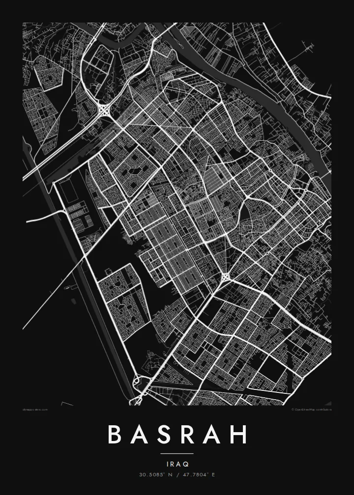
The broad waterway formed by the Tigris and Euphrates runs along the city's eastern edge, a wide, steady line that anchors the entire composition.
Pōsitā mape sitaila faingofua · ʻIlaaki
30.5085° N / 47.7804° E
A river port along the Shatt al-Arab, threaded by old canals and edged by wide groves of date palms



Kolo ʻe taha, ongoʻi ʻe nima
Tuki ha sitaile ke sio ai 'i ho holisi. 'Oku tatau pē 'a e totongi 'o e sitaile kotoa pē — tā pepa, fa'o, pe ko e fa'ile HD.
 Pika mo'oni · fa'ile tā 24 × 36″
Mahino ke paaki
Ko ha konga 100% eni mei he fa'ile tā mo'oni. Ko e posita kotoa pē — tā pepa, fa'o, pe download — 'oku ngaohi 'i he'emau sāvā 'i he 300 DPI, 'o a'u ki he 7,200 × 10,800 pika, koe'uhi ke mahino lelei 'a e ngaahi hala si'isi'i taha 'i ha tā 24 × 36″.
'I he pā


Ko e mape
Basrah lies on the Shatt al-Arab, the waterway formed where the Tigris and the Euphrates join upstream at Qurna. On the map, the river runs along the eastern side of the city toward the Gulf, and a network of canals branches off it through the urban area, which once earned Basrah the nickname the Venice of the East. Palm groves line the banks beyond the city.
Founded in 636 as a garrison town, Basrah became one of the great cities of the early Islamic world, known for its scholars and particularly for the school of Arabic grammar that developed here. It is also associated with the tales of Sinbad the Sailor, who set out on his voyages from its port, according to the stories.
A Basrah map poster traces the Shatt al-Arab, the canals and the pattern of streets between them, with the corniche following the river through the centre. Today Basrah is Iraq's main port city and a centre of its oil industry, but on the map it remains what it has always been: a city shaped by rivers, water and trade.
The broad waterway formed by the Tigris and Euphrates runs along the city's eastern edge, a wide, steady line that anchors the entire composition.
Canals branch off the river and wind through the city, fine lines of water that recall the network behind Basrah's old nickname, the Venice of the East.
Beyond the built-up area, date palm groves follow the riverbanks. On the map they appear as a softer, more open texture framing the dense streets of the city.
Ke ʻaʻau pē
Tānaki ha ʻaho, ha hingoa pe ha laine ʻaʻau, pea liliu ʻa e sitaila, saisi pe tuʻunga.
Ko e sio muʻa ta'etotongi 'oku ma'ulalo hono lelei pea 'oku ai hano fakaʻilonga vai. Ko e ngaahi tā mo e fa'ile HD 'oku ngaohi 'i he 300 DPI, 'o a'u ki he 7,200 × 10,800 px, ta'e ha fakaʻilonga vai.
Ko e hā ʻa Basrah
Basrah is a map for Iraqis at home and abroad, for those who have worked in its port and oil fields and for anyone who knows the city from literature and history. Its river and canals give the poster a strong and immediately readable structure.
Add a title in Arabic or English, a subtitle with a date or family name, and edit the coordinates line. Choose from five styles: Classic black & white, Noir, Paper, Blueprint or Sand. Sand reflects the colours of the southern plain and the river.
'Oda 'a e posita Basrah| Saisi paaki | Tuʻunga mahino | Ngaahi faile |
|---|---|---|
| 30 × 40 cm (11.8 × 15.7″) | 3,543 × 4,724 px | PNG · PDF |
| 29.7 × 42 cm (A3, 11.7 × 16.5″) | 3,508 × 4,961 px | PNG · PDF |
| 42 × 59.4 cm (A2, 16.5 × 23.4″) | 4,961 × 7,016 px | PNG · PDF |
| 45.7 × 61 cm (18 × 24″) | 5,400 × 7,200 px | PNG · PDF |
| 50 × 70 cm (19.7 × 27.6″) | 5,906 × 8,268 px | PNG · PDF |
| 61 × 91.4 cm (24 × 36″) | 7,200 × 10,800 px | PNG · PDF |
Ke fakafehoanaki, ko e sio fakamuʻa taʻetotongi ʻoku fālahi ʻaki ʻa e 900 px, ʻi ai hono fakaʻilonga-vai pea ki he ngaahi screen pē. ʻOku liunga 8 hono mahino ʻo e ngaahi faile HD ʻi he tafaʻaki kotoa pea ʻoku paaki lelei ʻi he saisi kakato ʻo e pōsitā.
Fili ha sitaile 'i he tumu'aki 'o e peesi, pea fili leva ha Posita Tā — ha lahi pea, kapau 'oku ke sai'ia, ha fa'o — pe ko e ngaahi Fa'ile Digital HD. Ko e Checkout ko e sitepu pē 'e taha, pea 'e fakafo'ou leva ho'o peesi 'oda 'i he taimi 'e a'u ai 'a e totongi.
'Oku tā ia 'i ha pepa matte 200 gsm mo'oni lelei taha, 'i ha taha 'o e ngaahi lahi 'e ono, mei he 30 × 40 cm ki he 24 × 36″. 'Oku kamata 'a e ngaahi posita kuo tā 'i he {printFrom}, kuo kau ai 'a e 'ave.
'Io. Fili ha fa'o 'akau mo'oni 'i he 'uli'uli, hina, oki fakanatula pe 'akau fu'u 'uli'uli. 'Oku fakataha mai mo ha sio'ata ta'emafesi pea kuo mateuteu ke tautau. 'Oku kamata 'a e ngaahi posita kuo fa'o 'i he {framedFrom}, kuo kau ai 'a e 'ave.
'Oku ta'etotongi 'a e 'ave 'i māmani kotoa. 'Oku tā 'a e posita taki taha 'e homau kaungāfakatau tā ofi taha 'i he ngaahi fonua 'e laka hake he 30, pea 'oku a'u lelei ia 'i he 'aho ngāue 'e 3–7. 'E lava ke ke sio ki hono tu'unga mo hono 'ave 'i lalo 'i he'eku Ngaahi 'Oda.
'Ave mai ha foto kiate kimautolu 'i he lolotonga 'o e 'aho 'e 14 mei he taimi na'e a'u mai ai, pea te mau toe tā ia ta'etotongi pe toe totongi atu 'a ho'o pa'anga.
'Io. 'I he editor 'i he peesi ni, liliu 'a e kaveinga, 'a e kaveinga si'i mo e laine fakafuofua ki ha me'a pē 'oku ke sai'ia ai, pea fili ha sitaile mo ha lahi. Ko e ngaahi 'oda tā, fa'o mo digital kotoa 'oku ngāue'aki ai pē ho'o fakatātā tofu pē.
'I he totongi 'e $9 'oku ke ma'u ai 'a e ngaahi fa'ile PNG 300 DPI mo e PDF kuo mateuteu ki he tā 'i he lahi 'e ono kotoa, 'ikai ha fakaʻilonga vai, ke tā ai 'i ha feitu'u pē. Te ke kei ta'epau? Download muʻa ha sio muʻa ta'etotongi 'oku ai hano fakaʻilonga vai.
Ofi mai
