The natural harbour
A long, narrow inlet on the northwest side is almost closed off by headlands. It gives the island its most recognisable shape and holds its only landing place.
Pōsitā mape sitaila faingofua · Sipeini
39.1454° N / 2.9453° E
A small, rocky Balearic island with a deep natural harbour guarded by a castle, south of Mallorca



Kolo ʻe taha, ongoʻi ʻe nima
Tuki ha sitaile ke sio ai 'i ho holisi. 'Oku tatau pē 'a e totongi 'o e sitaile kotoa pē — tā pepa, fa'o, pe ko e fa'ile HD.
 Pika mo'oni · fa'ile tā 24 × 36″
Mahino ke paaki
Ko ha konga 100% eni mei he fa'ile tā mo'oni. Ko e posita kotoa pē — tā pepa, fa'o, pe download — 'oku ngaohi 'i he'emau sāvā 'i he 300 DPI, 'o a'u ki he 7,200 × 10,800 pika, koe'uhi ke mahino lelei 'a e ngaahi hala si'isi'i taha 'i ha tā 24 × 36″.
'I he pā


Ko e mape
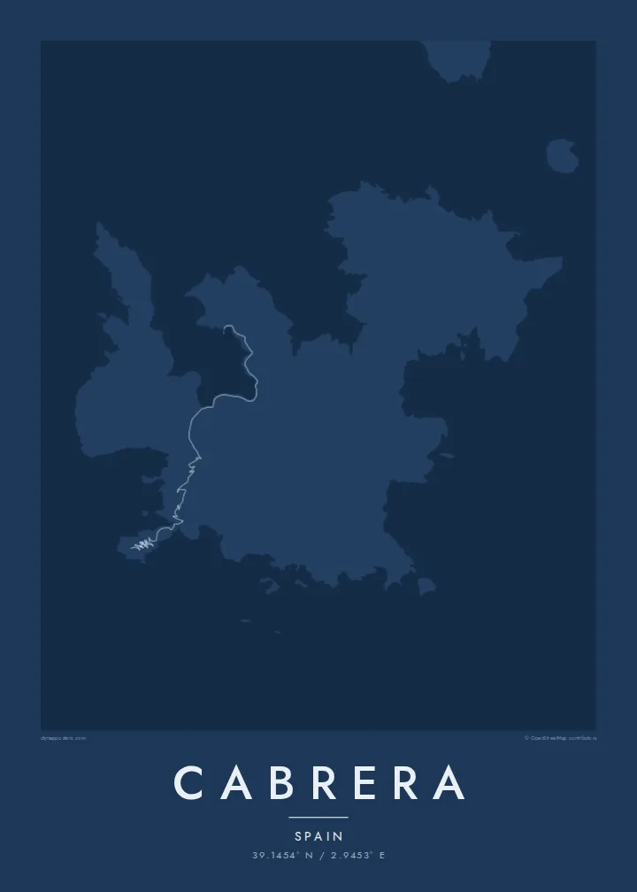
Cabrera lies a short boat ride south of Mallorca, surrounded by smaller islets. From above it has a jagged, lobed outline made of rocky headlands and deep coves. The most sheltered of these is a narrow natural harbour on the northwest side, almost enclosed by land. There are no roads in the usual sense, only footpaths that connect the harbour with lighthouses and viewpoints across the hills.
The island and its surrounding waters form a maritime-terrestrial national park, and visitor numbers are strictly limited. A medieval castle stands on a height above the harbour entrance. During the Napoleonic Wars, thousands of French prisoners were held on the island in harsh conditions, and a monument remembers them. Boat trips often stop at a sea cave known for its blue light.
A Cabrera map poster is almost all coastline: the enclosed harbour, the broken edges of the headlands and a cluster of islets around the main island. It shows a protected place that has stayed nearly empty, and that emptiness is what makes the map so clear.
A long, narrow inlet on the northwest side is almost closed off by headlands. It gives the island its most recognisable shape and holds its only landing place.
A castle overlooks the entrance to the harbour from a rocky height. On the map it sits at the narrowest point of the inlet.
Small islands and rocks cluster around Cabrera. Together they form a small archipelago that fills the sea around it on the poster.
Ke ʻaʻau pē
Tānaki ha ʻaho, ha hingoa pe ha laine ʻaʻau, pea liliu ʻa e sitaila, saisi pe tuʻunga.
Ko e sio muʻa ta'etotongi 'oku ma'ulalo hono lelei pea 'oku ai hano fakaʻilonga vai. Ko e ngaahi tā mo e fa'ile HD 'oku ngaohi 'i he 300 DPI, 'o a'u ki he 7,200 × 10,800 px, ta'e ha fakaʻilonga vai.
Ko e hā ʻa Cabrera
Cabrera appeals to sailors who have anchored in its harbour, divers who know its protected waters and anyone who has taken the boat across from Mallorca. The broken coastline looks especially sharp in Blueprint, where the sea turns deep blue.
Write your own title and subtitle, perhaps a boat's name or a sailing date, and choose from five styles. The download includes six print sizes at 300 DPI, and printed posters ship from partners in more than 30 countries.
'Oda 'a e posita Cabrera| Saisi paaki | Tuʻunga mahino | Ngaahi faile |
|---|---|---|
| 30 × 40 cm (11.8 × 15.7″) | 3,543 × 4,724 px | PNG · PDF |
| 29.7 × 42 cm (A3, 11.7 × 16.5″) | 3,508 × 4,961 px | PNG · PDF |
| 42 × 59.4 cm (A2, 16.5 × 23.4″) | 4,961 × 7,016 px | PNG · PDF |
| 45.7 × 61 cm (18 × 24″) | 5,400 × 7,200 px | PNG · PDF |
| 50 × 70 cm (19.7 × 27.6″) | 5,906 × 8,268 px | PNG · PDF |
| 61 × 91.4 cm (24 × 36″) | 7,200 × 10,800 px | PNG · PDF |
Ke fakafehoanaki, ko e sio fakamuʻa taʻetotongi ʻoku fālahi ʻaki ʻa e 900 px, ʻi ai hono fakaʻilonga-vai pea ki he ngaahi screen pē. ʻOku liunga 8 hono mahino ʻo e ngaahi faile HD ʻi he tafaʻaki kotoa pea ʻoku paaki lelei ʻi he saisi kakato ʻo e pōsitā.
Fili ha sitaile 'i he tumu'aki 'o e peesi, pea fili leva ha Posita Tā — ha lahi pea, kapau 'oku ke sai'ia, ha fa'o — pe ko e ngaahi Fa'ile Digital HD. Ko e Checkout ko e sitepu pē 'e taha, pea 'e fakafo'ou leva ho'o peesi 'oda 'i he taimi 'e a'u ai 'a e totongi.
'Oku tā ia 'i ha pepa matte 200 gsm mo'oni lelei taha, 'i ha taha 'o e ngaahi lahi 'e ono, mei he 30 × 40 cm ki he 24 × 36″. 'Oku kamata 'a e ngaahi posita kuo tā 'i he {printFrom}, kuo kau ai 'a e 'ave.
'Io. Fili ha fa'o 'akau mo'oni 'i he 'uli'uli, hina, oki fakanatula pe 'akau fu'u 'uli'uli. 'Oku fakataha mai mo ha sio'ata ta'emafesi pea kuo mateuteu ke tautau. 'Oku kamata 'a e ngaahi posita kuo fa'o 'i he {framedFrom}, kuo kau ai 'a e 'ave.
'Oku ta'etotongi 'a e 'ave 'i māmani kotoa. 'Oku tā 'a e posita taki taha 'e homau kaungāfakatau tā ofi taha 'i he ngaahi fonua 'e laka hake he 30, pea 'oku a'u lelei ia 'i he 'aho ngāue 'e 3–7. 'E lava ke ke sio ki hono tu'unga mo hono 'ave 'i lalo 'i he'eku Ngaahi 'Oda.
'Ave mai ha foto kiate kimautolu 'i he lolotonga 'o e 'aho 'e 14 mei he taimi na'e a'u mai ai, pea te mau toe tā ia ta'etotongi pe toe totongi atu 'a ho'o pa'anga.
'Io. 'I he editor 'i he peesi ni, liliu 'a e kaveinga, 'a e kaveinga si'i mo e laine fakafuofua ki ha me'a pē 'oku ke sai'ia ai, pea fili ha sitaile mo ha lahi. Ko e ngaahi 'oda tā, fa'o mo digital kotoa 'oku ngāue'aki ai pē ho'o fakatātā tofu pē.
'I he totongi 'e $9 'oku ke ma'u ai 'a e ngaahi fa'ile PNG 300 DPI mo e PDF kuo mateuteu ki he tā 'i he lahi 'e ono kotoa, 'ikai ha fakaʻilonga vai, ke tā ai 'i ha feitu'u pē. Te ke kei ta'epau? Download muʻa ha sio muʻa ta'etotongi 'oku ai hano fakaʻilonga vai.
