Euripus Strait
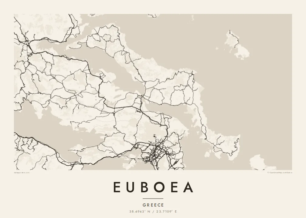
At Chalkida the channel between the island and the mainland narrows to a few dozen metres, and two bridges cross it. This tiny gap in the coastline defines the whole map.
Pōsitā mape sitaila faingofua · Kalisi
38.4943° N / 23.7109° E
A long, narrow island lying parallel to the Greek mainland, joined to it by bridges across a strait only metres wide




Kolo ʻe taha, ongoʻi ʻe nima
Tuki ha sitaile ke sio ai 'i ho holisi. 'Oku tatau pē 'a e totongi 'o e sitaile kotoa pē — tā pepa, fa'o, pe ko e fa'ile HD.
 Pika mo'oni · fa'ile tā 24 × 36″
Mahino ke paaki
Ko ha konga 100% eni mei he fa'ile tā mo'oni. Ko e posita kotoa pē — tā pepa, fa'o, pe download — 'oku ngaohi 'i he'emau sāvā 'i he 300 DPI, 'o a'u ki he 7,200 × 10,800 pika, koe'uhi ke mahino lelei 'a e ngaahi hala si'isi'i taha 'i ha tā 24 × 36″.
'I he pā


Ko e mape
Euboea is the second-largest island in Greece after Crete. It stretches for well over a hundred kilometres along the mainland coast northeast of Athens. On a map it is long, narrow and mountainous, and its axis mirrors the shape of the coast opposite. The North and South Euboean Gulfs lie between the two shores and almost close up at Chalkida, near the island's midpoint.
Chalkida, the largest town, sits at the narrowest point of the strait, the Euripus, where two bridges link the island to the mainland. The currents in the channel are well known: they change direction several times a day and have puzzled writers since ancient times. The town's streets fan out from the waterfront, and the mainland shore is only a short distance away.
The north of the island has long been known for its pine forests. The centre rises to the high peak of Dirfys, and the south narrows into a dry, rugged peninsula that ends near Karystos. Villages and small ports line both coasts, linked by roads that wind through the mountains. A Euboea map poster shows an island that feels almost part of the mainland, divided from it by a thread of sea.
At Chalkida the channel between the island and the mainland narrows to a few dozen metres, and two bridges cross it. This tiny gap in the coastline defines the whole map.
The island's highest mountain rises in central Euboea and gathers the contour lines tightly. Small roads climb to villages on its slopes and drop down to the east coast.
South of its midpoint, Euboea narrows into a long, mountainous arm that reaches toward Andros. It ends in a coast of small bays around Karystos.
Ke ʻaʻau pē
Tānaki ha ʻaho, ha hingoa pe ha laine ʻaʻau, pea liliu ʻa e sitaila, saisi pe tuʻunga.
Ko e sio muʻa ta'etotongi 'oku ma'ulalo hono lelei pea 'oku ai hano fakaʻilonga vai. Ko e ngaahi tā mo e fa'ile HD 'oku ngaohi 'i he 300 DPI, 'o a'u ki he 7,200 × 10,800 px, ta'e ha fakaʻilonga vai.
Ko e hā ʻa Euboea
For many Athenians, Euboea is a place of summer homes and family villages, and it is a quieter alternative to the better-known islands. Its long profile and the fine thread of the Euripus make it a striking shape on the wall.
You can write your own title and subtitle, perhaps naming a village or a year, and adjust the coordinates line. Choose from Classic black and white, Noir, Paper, Blueprint and Sand, then order a printed poster or download the HD files for $9.
'Oda 'a e posita Euboea| Saisi paaki | Tuʻunga mahino | Ngaahi faile |
|---|---|---|
| 30 × 40 cm11.8 × 15.7″ | 3,543 × 4,724 px | PNG · PDF |
| 29.7 × 42 cm (A3)11.7 × 16.5″ | 3,508 × 4,961 px | PNG · PDF |
| 42 × 59.4 cm (A2)16.5 × 23.4″ | 4,961 × 7,016 px | PNG · PDF |
| 45.7 × 61 cm18 × 24″ | 5,400 × 7,200 px | PNG · PDF |
| 50 × 70 cm19.7 × 27.6″ | 5,906 × 8,268 px | PNG · PDF |
| 61 × 91.4 cm24 × 36″ | 7,200 × 10,800 px | PNG · PDF |
Ke fakafehoanaki, ko e sio fakamuʻa taʻetotongi ʻoku fālahi ʻaki ʻa e 900 px, ʻi ai hono fakaʻilonga-vai pea ki he ngaahi screen pē. ʻOku liunga 8 hono mahino ʻo e ngaahi faile HD ʻi he tafaʻaki kotoa pea ʻoku paaki lelei ʻi he saisi kakato ʻo e pōsitā.
Fili ha sitaile 'i he tumu'aki 'o e peesi, pea fili leva ha Posita Tā — ha lahi pea, kapau 'oku ke sai'ia, ha fa'o — pe ko e ngaahi Fa'ile Digital HD. Ko e Checkout ko e sitepu pē 'e taha, pea 'e fakafo'ou leva ho'o peesi 'oda 'i he taimi 'e a'u ai 'a e totongi.
'Oku tā ia 'i ha pepa matte 200 gsm mo'oni lelei taha, 'i ha taha 'o e ngaahi lahi 'e ono, mei he 30 × 40 cm ki he 24 × 36″. 'Oku kamata 'a e ngaahi posita kuo tā 'i he $39, kuo kau ai 'a e 'ave.
'Io. Fili ha fa'o 'akau mo'oni 'i he 'uli'uli, hina, oki fakanatula pe 'akau fu'u 'uli'uli. 'Oku fakataha mai mo ha sio'ata ta'emafesi pea kuo mateuteu ke tautau. 'Oku kamata 'a e ngaahi posita kuo fa'o 'i he $99, kuo kau ai 'a e 'ave.
ʻOku ʻataʻatā ʻa e fakaheka ki he ngaahi fonua ʻe 60+. ʻOku paaki ʻa e tuʻunga taki taha ʻe he tokotaha paaki ofi taha ʻo kitautolu ʻi he ngaahi fonua ʻe 30+, pea ʻoku maʻu angamaheni ia ʻi he ʻaho ngāue ʻe 3–7. ʻE lava ke ke muimui ki he tuʻunga mo e fakaʻilo ʻi he ʻOku ou Fakamaʻu. ʻOku toki ʻaho ʻe 2–5 uike ʻa e ngaahi fonua si'i, pea ʻi he ngaahi fonua ʻoku te teʻeki ke fakaheka ki ai, ʻoku fakahā atu ʻe he uepisaiti ʻi he ʻuluaki ʻo e totongi.
'Ave mai ha foto kiate kimautolu 'i he lolotonga 'o e 'aho 'e 14 mei he taimi na'e a'u mai ai, pea te mau toe tā ia ta'etotongi pe toe totongi atu 'a ho'o pa'anga.
'Io. 'I he editor 'i he peesi ni, liliu 'a e kaveinga, 'a e kaveinga si'i mo e laine fakafuofua ki ha me'a pē 'oku ke sai'ia ai, pea fili ha sitaile mo ha lahi. Ko e ngaahi 'oda tā, fa'o mo digital kotoa 'oku ngāue'aki ai pē ho'o fakatātā tofu pē.
'I he totongi 'e $9 'oku ke ma'u ai 'a e ngaahi fa'ile PNG 300 DPI mo e PDF kuo mateuteu ki he tā 'i he lahi 'e ono kotoa, 'ikai ha fakaʻilonga vai, ke tā ai 'i ha feitu'u pē. Te ke kei ta'epau? Download muʻa ha sio muʻa ta'etotongi 'oku ai hano fakaʻilonga vai.
Ofi mai
