Interstate junction
I-70 and I-75 meet near Vandalia, and the interchange loops show up clearly from above. They frame the city with the widest and boldest lines on the print.
Pōsitā mape sitaila faingofua · Puleʻanga fakatahataha ʻAmelika
39.8906° N / 84.1988° W
An Ohio crossroads city north of Dayton, where interstates, the National Road and airport runways meet in a suburban grid


Kolo ʻe taha, ongoʻi ʻe nima
Tuki ha sitaile ke sio ai 'i ho holisi. 'Oku tatau pē 'a e totongi 'o e sitaile kotoa pē — tā pepa, fa'o, pe ko e fa'ile HD.
 Pika mo'oni · fa'ile tā 24 × 36″
Mahino ke paaki
Ko ha konga 100% eni mei he fa'ile tā mo'oni. Ko e posita kotoa pē — tā pepa, fa'o, pe download — 'oku ngaohi 'i he'emau sāvā 'i he 300 DPI, 'o a'u ki he 7,200 × 10,800 pika, koe'uhi ke mahino lelei 'a e ngaahi hala si'isi'i taha 'i ha tā 24 × 36″.
'I he pā


Ko e mape
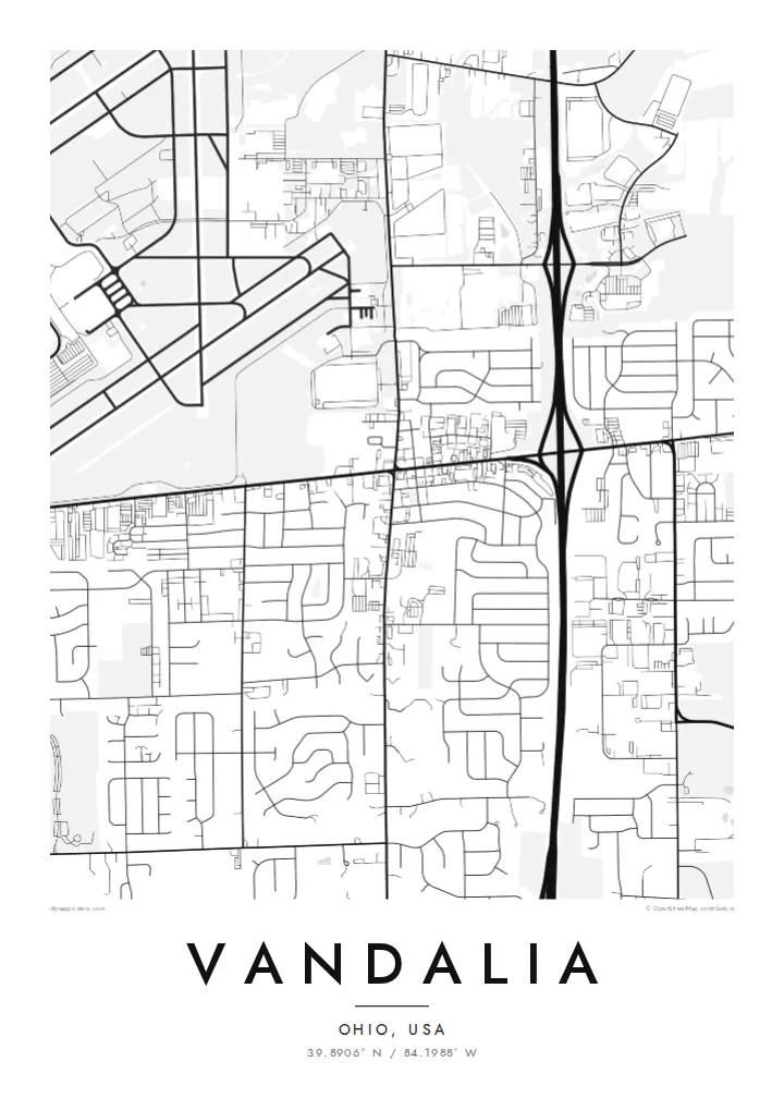
Vandalia lies just north of Dayton, Ohio, at a point where major routes come together. Interstate 75 runs north–south along its eastern side, Interstate 70 runs east–west through the area, and the historic National Road, now US 40, passes through the city. The local slogan, Crossroads of America, describes the map quite literally.
Dayton International Airport sits immediately to the west, and its runways form long, crossing lines at the edge of the city. Between the highways, Vandalia's residential streets follow a mostly regular grid with some curving subdivisions. Parks, schools and a compact centre along the old National Road break it up. Farmland still reaches the outer edges.
A Vandalia map poster shows a place defined by movement: interchanges, arterial roads and runways surrounding a quiet, ordinary suburb. In black and white, the heavy highway lines, the fine residential streets and the geometric airfield make one of the more graphic compositions among small Ohio cities.
I-70 and I-75 meet near Vandalia, and the interchange loops show up clearly from above. They frame the city with the widest and boldest lines on the print.
US 40, the historic National Road, runs through Vandalia. It was one of the first major federally built roads in the United States and still forms a central axis of the city.
Dayton International Airport lies just west of the city. Its runways and taxiways create a large geometric shape at the edge of the map.
Ke ʻaʻau pē
Tānaki ha ʻaho, ha hingoa pe ha laine ʻaʻau, pea liliu ʻa e sitaila, saisi pe tuʻunga.
Ko e sio muʻa ta'etotongi 'oku ma'ulalo hono lelei pea 'oku ai hano fakaʻilonga vai. Ko e ngaahi tā mo e fa'ile HD 'oku ngaohi 'i he 300 DPI, 'o a'u ki he 7,200 × 10,800 px, ta'e ha fakaʻilonga vai.
Ko e hā ʻa Vandalia
A map of Vandalia suits people from the Dayton area, aviation enthusiasts and anyone whose life has passed through this crossroads. It shows a familiar place with more structure and character than people usually expect.
Title it with your street, family or high school class, add a date, and keep the coordinates. Choose from Classic black & white, Noir, Paper, Blueprint or Sand. Order it printed on matte paper, with or without a wooden frame.
'Oda 'a e posita Vandalia| Saisi paaki | Tuʻunga mahino | Ngaahi faile |
|---|---|---|
| 30 × 40 cm11.8 × 15.7″ | 3,543 × 4,724 px | PNG · PDF |
| 29.7 × 42 cm (A3)11.7 × 16.5″ | 3,508 × 4,961 px | PNG · PDF |
| 42 × 59.4 cm (A2)16.5 × 23.4″ | 4,961 × 7,016 px | PNG · PDF |
| 45.7 × 61 cm18 × 24″ | 5,400 × 7,200 px | PNG · PDF |
| 50 × 70 cm19.7 × 27.6″ | 5,906 × 8,268 px | PNG · PDF |
| 61 × 91.4 cm24 × 36″ | 7,200 × 10,800 px | PNG · PDF |
Ke fakafehoanaki, ko e sio fakamuʻa taʻetotongi ʻoku fālahi ʻaki ʻa e 900 px, ʻi ai hono fakaʻilonga-vai pea ki he ngaahi screen pē. ʻOku liunga 8 hono mahino ʻo e ngaahi faile HD ʻi he tafaʻaki kotoa pea ʻoku paaki lelei ʻi he saisi kakato ʻo e pōsitā.
Fili ha sitaile 'i he tumu'aki 'o e peesi, pea fili leva ha Posita Tā — ha lahi pea, kapau 'oku ke sai'ia, ha fa'o — pe ko e ngaahi Fa'ile Digital HD. Ko e Checkout ko e sitepu pē 'e taha, pea 'e fakafo'ou leva ho'o peesi 'oda 'i he taimi 'e a'u ai 'a e totongi.
'Oku tā ia 'i ha pepa matte 200 gsm mo'oni lelei taha, 'i ha taha 'o e ngaahi lahi 'e ono, mei he 30 × 40 cm ki he 24 × 36″. 'Oku kamata 'a e ngaahi posita kuo tā 'i he $39, kuo kau ai 'a e 'ave.
'Io. Fili ha fa'o 'akau mo'oni 'i he 'uli'uli, hina, oki fakanatula pe 'akau fu'u 'uli'uli. 'Oku fakataha mai mo ha sio'ata ta'emafesi pea kuo mateuteu ke tautau. 'Oku kamata 'a e ngaahi posita kuo fa'o 'i he $99, kuo kau ai 'a e 'ave.
ʻOku ʻataʻatā ʻa e fakaheka ki he ngaahi fonua ʻe 60+. ʻOku paaki ʻa e tuʻunga taki taha ʻe he tokotaha paaki ofi taha ʻo kitautolu ʻi he ngaahi fonua ʻe 30+, pea ʻoku maʻu angamaheni ia ʻi he ʻaho ngāue ʻe 3–7. ʻE lava ke ke muimui ki he tuʻunga mo e fakaʻilo ʻi he ʻOku ou Fakamaʻu. ʻOku toki ʻaho ʻe 2–5 uike ʻa e ngaahi fonua si'i, pea ʻi he ngaahi fonua ʻoku te teʻeki ke fakaheka ki ai, ʻoku fakahā atu ʻe he uepisaiti ʻi he ʻuluaki ʻo e totongi.
'Ave mai ha foto kiate kimautolu 'i he lolotonga 'o e 'aho 'e 14 mei he taimi na'e a'u mai ai, pea te mau toe tā ia ta'etotongi pe toe totongi atu 'a ho'o pa'anga.
'Io. 'I he editor 'i he peesi ni, liliu 'a e kaveinga, 'a e kaveinga si'i mo e laine fakafuofua ki ha me'a pē 'oku ke sai'ia ai, pea fili ha sitaile mo ha lahi. Ko e ngaahi 'oda tā, fa'o mo digital kotoa 'oku ngāue'aki ai pē ho'o fakatātā tofu pē.
'I he totongi 'e $9 'oku ke ma'u ai 'a e ngaahi fa'ile PNG 300 DPI mo e PDF kuo mateuteu ki he tā 'i he lahi 'e ono kotoa, 'ikai ha fakaʻilonga vai, ke tā ai 'i ha feitu'u pē. Te ke kei ta'epau? Download muʻa ha sio muʻa ta'etotongi 'oku ai hano fakaʻilonga vai.
Ofi mai
