Mountain road
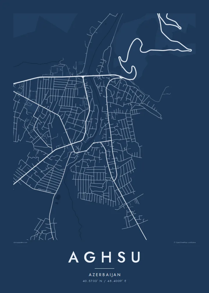
The route toward Shamakhi winds up into the foothills in a series of curves. On the poster it is the most dramatic line in the composition.
Pousita mape faigofie · Azerbaijan
40.5703° N / 48.4009° E
A small Azerbaijani town at the foot of the Caucasus foothills, where the mountain road descends toward the Kura plain



Taone e tasi, lagona e lima
Pau te tapaki o se style ke lavea i luga i te puipui. E tutasi te tau o style takitasi — telotele mo faaki, e aunoa io me fai ki faila HD.
 Pixel tonu · faila lolomi 24 × 36″
Manino ki te lomiga
Tenei se 100% mai te faila lolomi tonu. Poster takitasi — telotele, faaki io me download — e faite i luga i a matou server i te 300 DPI, e oko atu ki 7,200 × 10,800 pixel, ko ala e maofio ei mo maiga vaega foliki i luga i te lolomi 24 × 36″.
I te pakitala


Te mape
Aghsu lies in central Azerbaijan, where the southern foothills of the Greater Caucasus give way to the lower plains. The main road from Baku climbs through the area toward Shamakhi, and the town grew beside that route. On a map, a fairly regular pattern of streets sits between hilly ground to the north and flatter land to the south.
The surrounding district is agricultural, with vineyards, grain fields and orchards spreading across the lower ground. An Aghsu map poster captures this meeting of terrain: winding roads in the hills, straighter lines on the plain, and the town in the middle linking the two.
The area has a long history of settlement, and archaeological work nearby has uncovered remains of an older medieval town. Today Aghsu is the administrative centre of its district. In monochrome, its tidy streets and the curving mountain road stand out clearly against the open land around it.
The route toward Shamakhi winds up into the foothills in a series of curves. On the poster it is the most dramatic line in the composition.
The town centre has an orderly layout of streets and blocks. It is compact and easy to read at poster scale.
South of town the land flattens into farmland. Straight field roads and open spaces balance the busier hill terrain to the north.
Fai ke fakatau ki a koe
Fakaopoopo se aso, se igoa io me se fuaiupu o koe, sui te sitaila, te lasi io me te tuuga.
Te preview fua e maulalo te malamalama kae iai se watermark. Poster telotele mo faila HD e faite i te 300 DPI, e oko atu ki 7,200 × 10,800 px, aunoa mo se watermark.
Kaia a Aghsu
For people from the Aghsu district, or travellers who have driven the road between Baku and the mountains, this map marks a specific point in the landscape where the terrain changes. It is a modest, personal piece for a wall.
You can change the title, subtitle and coordinates line to add a name, a date or a place of origin. Choose one of five styles: Classic black & white, Noir, Paper, Blueprint and Sand.
Otaina te poster Aghsu| Lasi o te lomiga | Manino | Faila |
|---|---|---|
| 30 × 40 cm11.8 × 15.7″ | 3,543 × 4,724 px | PNG · PDF |
| 29.7 × 42 cm (A3)11.7 × 16.5″ | 3,508 × 4,961 px | PNG · PDF |
| 42 × 59.4 cm (A2)16.5 × 23.4″ | 4,961 × 7,016 px | PNG · PDF |
| 45.7 × 61 cm18 × 24″ | 5,400 × 7,200 px | PNG · PDF |
| 50 × 70 cm19.7 × 27.6″ | 5,906 × 8,268 px | PNG · PDF |
| 61 × 91.4 cm24 × 36″ | 7,200 × 10,800 px | PNG · PDF |
Ke fakatusa, a te ata fakataitai fua e 900 px te lautele, mo te fakailoga kae mo lau lavea i luga i te komipiuta. A faila HD e oko ki te 8× te manino i itu katoa kae lomi faka‵lei i te lasi katoa o te pousita.
Filifili se style i te pito i luga o te itulau, kae filifili Poster Telotele — se lasi mo se faaki manafai e manako koe — io me Faila Digital HD. E tasi te sitepu mo te checkout, kae ka fakafou te itulau o tau ota i te taimi e mafai ei te totogi.
E telotele i luga o te pepa vali gali 200 gsm i se tasi mai lasi e ono, mai te 30 × 40 cm ki te 24 × 36″. E kamata te poster telotele mai i te $39, kae aofia ei te uta.
Ioe. Filifili se faaki lakau maoli i te kulokula, tea, oak maoli io me lakau pogisa. E oo mai ki tioata e se malepe kae toka ke tautau. E kamata te poster faaki mai i te $99, kae aofia ei te uta.
E tuku fua ki fenua e 60+. A poloaiga taki tasi e ta ne te tauhaga e latalata mai i a matou tauhaga ta i fenua e 30+, kae e masani o aunoa i aso galue e 3–7. E mafai o salasala te tulaga mo te sukesuke i lalo o Aku poloaiga. I nisi fenua e 2–5 vaiaso, kae i mea e seki tuku atu ei matou, e fakailoa atu e te mea tafaoga i mua o te totogi.
Auina mai se ata i loto i te 14 aso mai te taimi e oko ei kae ka toe telotele fua ne matou io me toe totogi atu tau tupe.
Ioe. I te editor i te itulau tenei, sui te ulutala, te ulutala lalo mo te laina o coordinate ki so se mea e manako koe, kae filifili se style mo se lasi. Oga telotele, faaki mo digital e faigana katoa i tau tusiga tonu.
Mo te $9 ka maua ne koe faila PNG 300 DPI mo PDF fakatoka lolomi i lasi e ono katoa, aunoa mo se watermark, ke lolomi i so se koga. E se mautinoa koe? Download muamua se preview fua e iai te watermark.
