Town centre
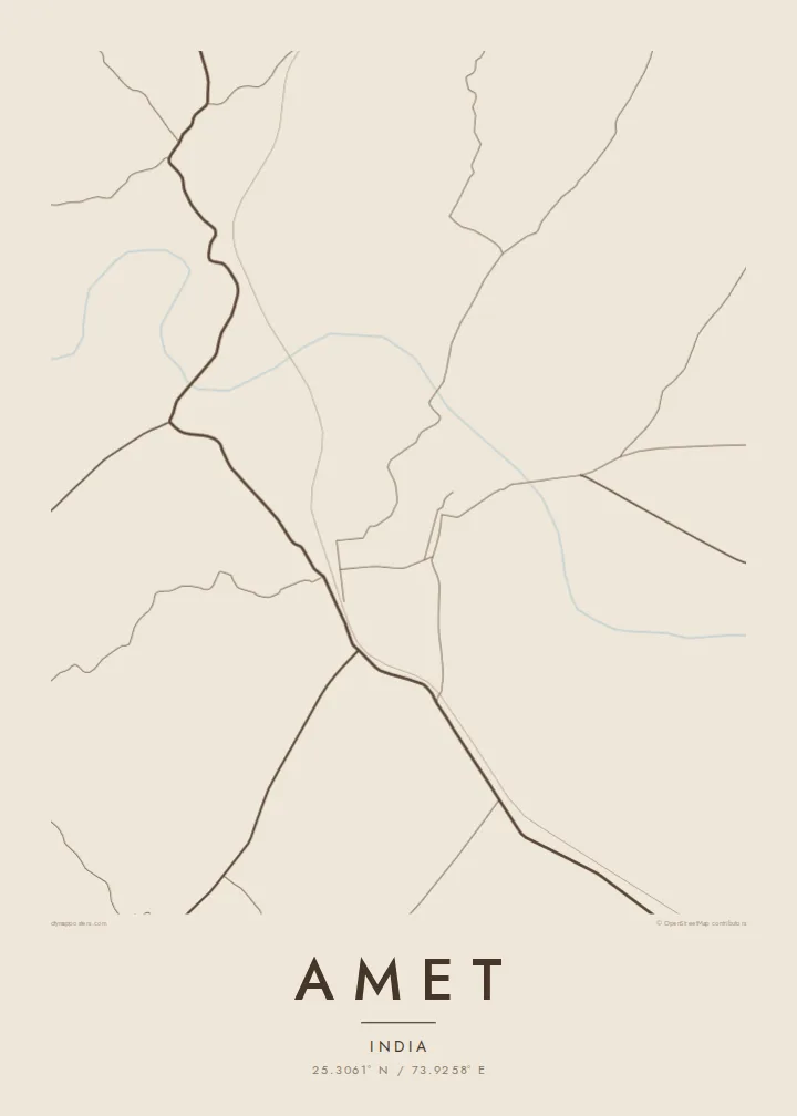
Narrow lanes and closely packed buildings form a compact core. On the poster this concentrated area contrasts sharply with the open hills around it.
Pousita mape faigofie · India
25.3061° N / 73.9258° E
A small town in Rajasthan's Rajsamand district, set among rocky Aravalli ridges, with roads threading between dry hills.


Taone e tasi, lagona e lima
Pau te tapaki o se style ke lavea i luga i te puipui. E tutasi te tau o style takitasi — telotele mo faaki, e aunoa io me fai ki faila HD.
 Pixel tonu · faila lolomi 24 × 36″
Manino ki te lomiga
Tenei se 100% mai te faila lolomi tonu. Poster takitasi — telotele, faaki io me download — e faite i luga i a matou server i te 300 DPI, e oko atu ki 7,200 × 10,800 pixel, ko ala e maofio ei mo maiga vaega foliki i luga i te lolomi 24 × 36″.
I te pakitala


Te mape
Amet lies in Rajsamand district in southern Rajasthan, in broken country where the Aravalli range spreads into low, rocky hills. The map shows a compact centre of narrow lanes, with roads leaving in several directions and finding their way between ridges. Seasonal streams and small bodies of water mark the lower ground, and fields fill whatever flat land the hills leave.
The town belongs to the historic region of Mewar, and for centuries it was the seat of one of the noble estates owing allegiance to the rulers of Udaipur. Today it is a tehsil headquarters and a local town for the surrounding villages, with markets serving the farming communities of the area.
An Amet map poster shows a town closely tied to its terrain. The dense core, the roads bending around the hills and the pale, open ground of the ridges give the print an unusual, irregular rhythm, far from the ordered grids of planned towns.
Narrow lanes and closely packed buildings form a compact core. On the poster this concentrated area contrasts sharply with the open hills around it.
Rocky hills rise around the town and push the roads into curves and detours. They leave broad empty shapes that frame the built-up area.
Seasonal streams and small water bodies sit in the dips between hills. They add soft, irregular marks to the lower parts of the map.
Fai ke fakatau ki a koe
Fakaopoopo se aso, se igoa io me se fuaiupu o koe, sui te sitaila, te lasi io me te tuuga.
Te preview fua e maulalo te malamalama kae iai se watermark. Poster telotele mo faila HD e faite i te 300 DPI, e oko atu ki 7,200 × 10,800 px, aunoa mo se watermark.
Kaia a Amet
For families with roots in Mewar, Amet is more than a name on the road from Rajsamand. A map of the town keeps its lanes and hills on the wall, and makes a meaningful gift for elders or for relatives settled in other cities.
The poster can be personalised with a title, a subtitle such as a family name or a date, and a coordinates line. Sand and Paper suit the dry hills, while Noir is bolder. HD files are $9, and printed matte posters can be ordered with an optional wooden frame.
Otaina te poster Amet| Lasi o te lomiga | Manino | Faila |
|---|---|---|
| 30 × 40 cm11.8 × 15.7″ | 3,543 × 4,724 px | PNG · PDF |
| 29.7 × 42 cm (A3)11.7 × 16.5″ | 3,508 × 4,961 px | PNG · PDF |
| 42 × 59.4 cm (A2)16.5 × 23.4″ | 4,961 × 7,016 px | PNG · PDF |
| 45.7 × 61 cm18 × 24″ | 5,400 × 7,200 px | PNG · PDF |
| 50 × 70 cm19.7 × 27.6″ | 5,906 × 8,268 px | PNG · PDF |
| 61 × 91.4 cm24 × 36″ | 7,200 × 10,800 px | PNG · PDF |
Ke fakatusa, a te ata fakataitai fua e 900 px te lautele, mo te fakailoga kae mo lau lavea i luga i te komipiuta. A faila HD e oko ki te 8× te manino i itu katoa kae lomi faka‵lei i te lasi katoa o te pousita.
Filifili se style i te pito i luga o te itulau, kae filifili Poster Telotele — se lasi mo se faaki manafai e manako koe — io me Faila Digital HD. E tasi te sitepu mo te checkout, kae ka fakafou te itulau o tau ota i te taimi e mafai ei te totogi.
E telotele i luga o te pepa vali gali 200 gsm i se tasi mai lasi e ono, mai te 30 × 40 cm ki te 24 × 36″. E kamata te poster telotele mai i te $39, kae aofia ei te uta.
Ioe. Filifili se faaki lakau maoli i te kulokula, tea, oak maoli io me lakau pogisa. E oo mai ki tioata e se malepe kae toka ke tautau. E kamata te poster faaki mai i te $99, kae aofia ei te uta.
E tuku fua ki fenua e 60+. A poloaiga taki tasi e ta ne te tauhaga e latalata mai i a matou tauhaga ta i fenua e 30+, kae e masani o aunoa i aso galue e 3–7. E mafai o salasala te tulaga mo te sukesuke i lalo o Aku poloaiga. I nisi fenua e 2–5 vaiaso, kae i mea e seki tuku atu ei matou, e fakailoa atu e te mea tafaoga i mua o te totogi.
Auina mai se ata i loto i te 14 aso mai te taimi e oko ei kae ka toe telotele fua ne matou io me toe totogi atu tau tupe.
Ioe. I te editor i te itulau tenei, sui te ulutala, te ulutala lalo mo te laina o coordinate ki so se mea e manako koe, kae filifili se style mo se lasi. Oga telotele, faaki mo digital e faigana katoa i tau tusiga tonu.
Mo te $9 ka maua ne koe faila PNG 300 DPI mo PDF fakatoka lolomi i lasi e ono katoa, aunoa mo se watermark, ke lolomi i so se koga. E se mautinoa koe? Download muamua se preview fua e iai te watermark.
