Dwarakeswar River
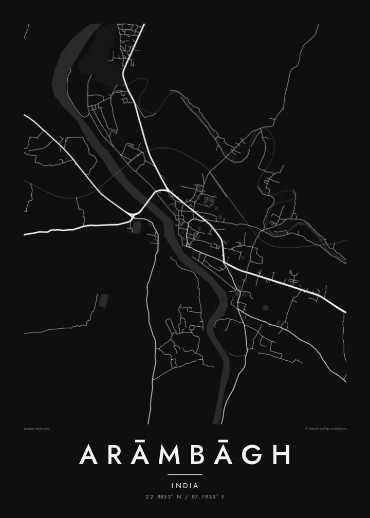
The river winds through the town in loose curves. It is the strongest natural line on the map and the feature the older settlement grew around.
Pousita mape faigofie · India
22.8833° N / 87.7833° E
A river town on the Dwarakeswar, where a compact centre gives way to the flat rice plains of Hooghly district.



Taone e tasi, lagona e lima
Pau te tapaki o se style ke lavea i luga i te puipui. E tutasi te tau o style takitasi — telotele mo faaki, e aunoa io me fai ki faila HD.
 Pixel tonu · faila lolomi 24 × 36″
Manino ki te lomiga
Tenei se 100% mai te faila lolomi tonu. Poster takitasi — telotele, faaki io me download — e faite i luga i a matou server i te 300 DPI, e oko atu ki 7,200 × 10,800 pixel, ko ala e maofio ei mo maiga vaega foliki i luga i te lolomi 24 × 36″.
I te pakitala


Te mape
Arāmbāgh is a subdivisional town in the Hooghly district of West Bengal, on the banks of the Dwarakeswar River. On a map the river is the main organising line. It winds through the town while roads branch out toward the surrounding villages. The built-up core is dense and irregular, and beyond it the land opens into the level farmland typical of the lower Bengal plain.
The region is low and fertile, laced with streams, ponds and irrigation channels, and its rivers are known to rise sharply during the monsoon. That relationship with water shapes both the farmland and the way the town has grown, with houses clustered on firmer ground. Arāmbāgh is a market and administrative centre for the surrounding area and has good road links to Kolkata and Bankura.
An Arāmbāgh map poster reduces this landscape to its essentials: the curving river, the knot of streets in the centre, and the roads reaching out across the plain. Ponds and water bodies appear as small scattered shapes that give the composition a quiet rhythm. It is a thoughtful piece for anyone from the town or the wider Hooghly district who wants a clear picture of home.
The river winds through the town in loose curves. It is the strongest natural line on the map and the feature the older settlement grew around.
Many small ponds and water tanks dot the town and its outskirts, as in most Bengal settlements. On the map they show up as a scatter of pale shapes between the streets.
Main roads leave the centre in several directions and run across open, flat farmland. They link the town with Kolkata, Bankura and the surrounding villages.
Fai ke fakatau ki a koe
Fakaopoopo se aso, se igoa io me se fuaiupu o koe, sui te sitaila, te lasi io me te tuuga.
Te preview fua e maulalo te malamalama kae iai se watermark. Poster telotele mo faila HD e faite i te 300 DPI, e oko atu ki 7,200 × 10,800 px, aunoa mo se watermark.
Kaia a Arāmbāgh
For families with roots in Arāmbāgh, including those who have moved to Kolkata or further afield, this map keeps the river and the old streets in view. It also works as a simple, graphic piece that fits a modern room.
Personalise the title, subtitle and coordinates line with a family name or an important date, and choose between Classic black & white, Noir, Paper, Blueprint and Sand. Digital HD files cost $9. Matte prints, with an optional wooden frame, ship from partners in over 30 countries.
Otaina te poster Arāmbāgh| Lasi o te lomiga | Manino | Faila |
|---|---|---|
| 30 × 40 cm11.8 × 15.7″ | 3,543 × 4,724 px | PNG · PDF |
| 29.7 × 42 cm (A3)11.7 × 16.5″ | 3,508 × 4,961 px | PNG · PDF |
| 42 × 59.4 cm (A2)16.5 × 23.4″ | 4,961 × 7,016 px | PNG · PDF |
| 45.7 × 61 cm18 × 24″ | 5,400 × 7,200 px | PNG · PDF |
| 50 × 70 cm19.7 × 27.6″ | 5,906 × 8,268 px | PNG · PDF |
| 61 × 91.4 cm24 × 36″ | 7,200 × 10,800 px | PNG · PDF |
Ke fakatusa, a te ata fakataitai fua e 900 px te lautele, mo te fakailoga kae mo lau lavea i luga i te komipiuta. A faila HD e oko ki te 8× te manino i itu katoa kae lomi faka‵lei i te lasi katoa o te pousita.
Filifili se style i te pito i luga o te itulau, kae filifili Poster Telotele — se lasi mo se faaki manafai e manako koe — io me Faila Digital HD. E tasi te sitepu mo te checkout, kae ka fakafou te itulau o tau ota i te taimi e mafai ei te totogi.
E telotele i luga o te pepa vali gali 200 gsm i se tasi mai lasi e ono, mai te 30 × 40 cm ki te 24 × 36″. E kamata te poster telotele mai i te $39, kae aofia ei te uta.
Ioe. Filifili se faaki lakau maoli i te kulokula, tea, oak maoli io me lakau pogisa. E oo mai ki tioata e se malepe kae toka ke tautau. E kamata te poster faaki mai i te $99, kae aofia ei te uta.
E tuku fua ki fenua e 60+. A poloaiga taki tasi e ta ne te tauhaga e latalata mai i a matou tauhaga ta i fenua e 30+, kae e masani o aunoa i aso galue e 3–7. E mafai o salasala te tulaga mo te sukesuke i lalo o Aku poloaiga. I nisi fenua e 2–5 vaiaso, kae i mea e seki tuku atu ei matou, e fakailoa atu e te mea tafaoga i mua o te totogi.
Auina mai se ata i loto i te 14 aso mai te taimi e oko ei kae ka toe telotele fua ne matou io me toe totogi atu tau tupe.
Ioe. I te editor i te itulau tenei, sui te ulutala, te ulutala lalo mo te laina o coordinate ki so se mea e manako koe, kae filifili se style mo se lasi. Oga telotele, faaki mo digital e faigana katoa i tau tusiga tonu.
Mo te $9 ka maua ne koe faila PNG 300 DPI mo PDF fakatoka lolomi i lasi e ono katoa, aunoa mo se watermark, ke lolomi i so se koga. E se mautinoa koe? Download muamua se preview fua e iai te watermark.
