Lake Basotu
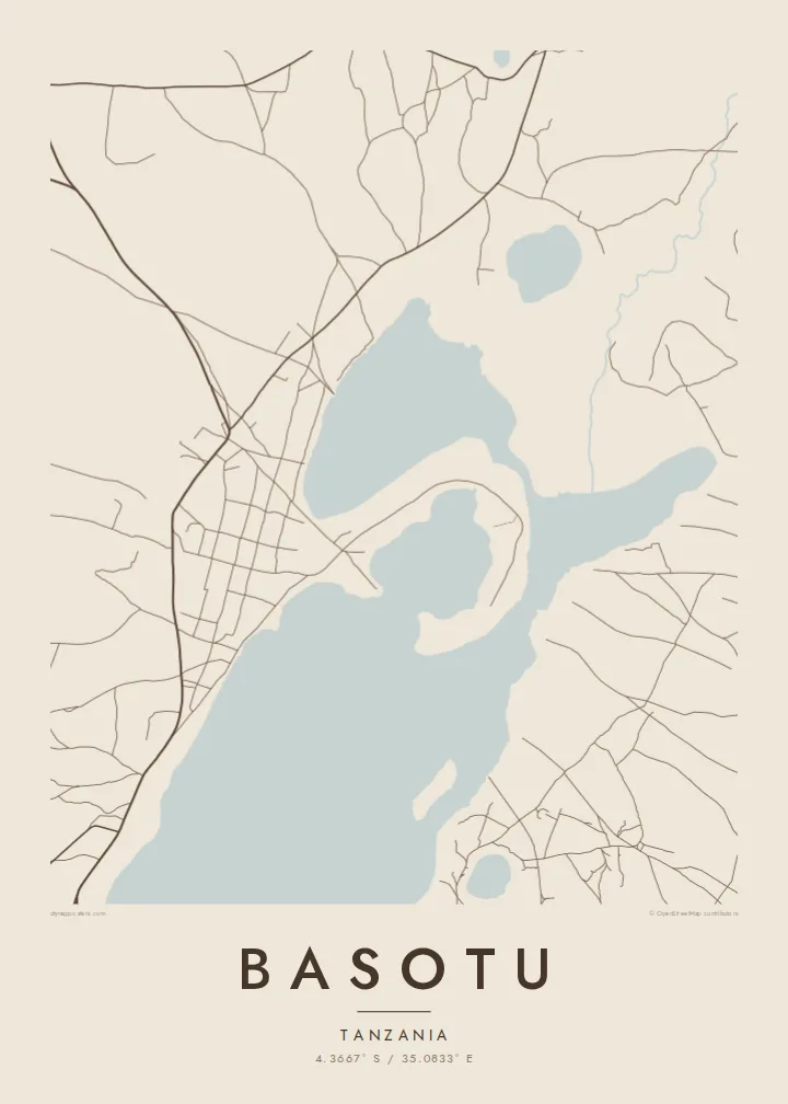
The lake beside the town is the dominant form on the map. Its solid shape anchors the composition and gives the settlement its outline along the shore.
Pousita mape faigofie · Tanzania
4.3667° S / 35.0833° E
A small Hanang town beside the waters of Lake Basotu, with open farmland and scattered tracks spreading in every direction.


Taone e tasi, lagona e lima
Pau te tapaki o se style ke lavea i luga i te puipui. E tutasi te tau o style takitasi — telotele mo faaki, e aunoa io me fai ki faila HD.
 Pixel tonu · faila lolomi 24 × 36″
Manino ki te lomiga
Tenei se 100% mai te faila lolomi tonu. Poster takitasi — telotele, faaki io me download — e faite i luga i a matou server i te 300 DPI, e oko atu ki 7,200 × 10,800 pixel, ko ala e maofio ei mo maiga vaega foliki i luga i te lolomi 24 × 36″.
I te pakitala


Te mape
Basotu lies in Hanang District of Manyara Region, in the highlands of northern Tanzania. From above, the most striking feature is water. Lake Basotu sits right beside the town, a compact body of water that gives the map a clear focal point in otherwise open country. Houses and compounds cluster near its shore, and unpaved roads fan out toward villages and fields.
The wider district is dominated by Mount Hanang, one of the highest peaks in Tanzania, which rises to the east. The plains around Basotu are farming and grazing land, home to Barabaig and Iraqw communities among others, and large wheat farms have been part of the area's story. On the map this appears as broad, lightly marked terrain rather than dense streets.
Because the settlement is small, a Basotu map poster works best as a portrait of the place and its setting together: the shape of the lake, the loose ring of buildings and the few tracks heading out across the land. It is a sparse, calm composition, and that restraint is exactly what makes it read well in black and white.
The lake beside the town is the dominant form on the map. Its solid shape anchors the composition and gives the settlement its outline along the shore.
Unpaved roads leave the town in several directions toward farms and neighbouring villages. They draw thin lines across open ground and show how much space surrounds Basotu.
The town belongs to the district named after Mount Hanang, a free-standing volcanic mountain to the east that defines the wider landscape of this part of Manyara.
Fai ke fakatau ki a koe
Fakaopoopo se aso, se igoa io me se fuaiupu o koe, sui te sitaila, te lasi io me te tuuga.
Te preview fua e maulalo te malamalama kae iai se watermark. Poster telotele mo faila HD e faite i te 300 DPI, e oko atu ki 7,200 × 10,800 px, aunoa mo se watermark.
Kaia a Basotu
A map of Basotu usually belongs to someone with a direct connection: people who were born here, taught or worked in the district, or spent time on a project near the lake. It records a quiet place that rarely appears on any printed map.
You can personalise the title, subtitle and coordinates line, perhaps with the years you lived there. The design comes in five styles (Classic black & white, Noir, Paper, Blueprint and Sand) and can be downloaded as 300 DPI files or ordered as a printed poster.
Otaina te poster Basotu| Lasi o te lomiga | Manino | Faila |
|---|---|---|
| 30 × 40 cm11.8 × 15.7″ | 3,543 × 4,724 px | PNG · PDF |
| 29.7 × 42 cm (A3)11.7 × 16.5″ | 3,508 × 4,961 px | PNG · PDF |
| 42 × 59.4 cm (A2)16.5 × 23.4″ | 4,961 × 7,016 px | PNG · PDF |
| 45.7 × 61 cm18 × 24″ | 5,400 × 7,200 px | PNG · PDF |
| 50 × 70 cm19.7 × 27.6″ | 5,906 × 8,268 px | PNG · PDF |
| 61 × 91.4 cm24 × 36″ | 7,200 × 10,800 px | PNG · PDF |
Ke fakatusa, a te ata fakataitai fua e 900 px te lautele, mo te fakailoga kae mo lau lavea i luga i te komipiuta. A faila HD e oko ki te 8× te manino i itu katoa kae lomi faka‵lei i te lasi katoa o te pousita.
Filifili se style i te pito i luga o te itulau, kae filifili Poster Telotele — se lasi mo se faaki manafai e manako koe — io me Faila Digital HD. E tasi te sitepu mo te checkout, kae ka fakafou te itulau o tau ota i te taimi e mafai ei te totogi.
E telotele i luga o te pepa vali gali 200 gsm i se tasi mai lasi e ono, mai te 30 × 40 cm ki te 24 × 36″. E kamata te poster telotele mai i te $39, kae aofia ei te uta.
Ioe. Filifili se faaki lakau maoli i te kulokula, tea, oak maoli io me lakau pogisa. E oo mai ki tioata e se malepe kae toka ke tautau. E kamata te poster faaki mai i te $99, kae aofia ei te uta.
E tuku fua ki fenua e 60+. A poloaiga taki tasi e ta ne te tauhaga e latalata mai i a matou tauhaga ta i fenua e 30+, kae e masani o aunoa i aso galue e 3–7. E mafai o salasala te tulaga mo te sukesuke i lalo o Aku poloaiga. I nisi fenua e 2–5 vaiaso, kae i mea e seki tuku atu ei matou, e fakailoa atu e te mea tafaoga i mua o te totogi.
Auina mai se ata i loto i te 14 aso mai te taimi e oko ei kae ka toe telotele fua ne matou io me toe totogi atu tau tupe.
Ioe. I te editor i te itulau tenei, sui te ulutala, te ulutala lalo mo te laina o coordinate ki so se mea e manako koe, kae filifili se style mo se lasi. Oga telotele, faaki mo digital e faigana katoa i tau tusiga tonu.
Mo te $9 ka maua ne koe faila PNG 300 DPI mo PDF fakatoka lolomi i lasi e ono katoa, aunoa mo se watermark, ke lolomi i so se koga. E se mautinoa koe? Download muamua se preview fua e iai te watermark.
