Mississippi bend
The river sweeps along the town's northern edge in a wide arc, its banks lined with the levee, wharves and industrial sites that face the shipping channel.
Pousita mape faigofie · United States
29.9430° N / 89.9654° W
A riverside grid on the Mississippi's east bank, levee on one side and wetlands opening toward the Gulf on the other


Taone e tasi, lagona e lima
Pau te tapaki o se style ke lavea i luga i te puipui. E tutasi te tau o style takitasi — telotele mo faaki, e aunoa io me fai ki faila HD.
 Pixel tonu · faila lolomi 24 × 36″
Manino ki te lomiga
Tenei se 100% mai te faila lolomi tonu. Poster takitasi — telotele, faaki io me download — e faite i luga i a matou server i te 300 DPI, e oko atu ki 7,200 × 10,800 pixel, ko ala e maofio ei mo maiga vaega foliki i luga i te lolomi 24 × 36″.
I te pakitala


Te mape
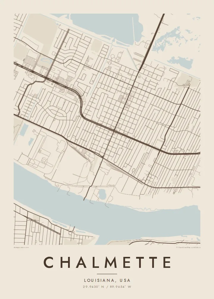
Chalmette lies just downriver from New Orleans in St. Bernard Parish, on a strip of higher ground along the east bank of the Mississippi. On a map the river curves across the top of the town, lined by the levee and industrial frontage. Behind it, a regular grid of residential streets fills the land between the river and the marshes that stretch away toward the east.
The town is best known as the site of the Battle of New Orleans in January 1815. The battlefield, now part of Jean Lafitte National Historical Park and Preserve, sits beside the river as an open rectangle of land, clearly visible among the surrounding blocks. The same low ground made Chalmette one of the places hit hardest by the flooding after Hurricane Katrina in 2005.
A Chalmette map poster shows how closely life here depends on water. The broad bend of the river, the straight canals and drainage lines, and the grid that stops at the wetland edge together describe a place defined by elevation measured in feet. In monochrome that relationship is easy to read at a glance.
The river sweeps along the town's northern edge in a wide arc, its banks lined with the levee, wharves and industrial sites that face the shipping channel.
The 1815 battlefield is an open, rectangular green by the river. On the poster it appears as a calm gap among the streets, with the national cemetery next to it.
Residential blocks run in an orderly grid until they meet canals and wetlands. That boundary between built land and open water gives the map its character.
Fai ke fakatau ki a koe
Fakaopoopo se aso, se igoa io me se fuaiupu o koe, sui te sitaila, te lasi io me te tuuga.
Te preview fua e maulalo te malamalama kae iai se watermark. Poster telotele mo faila HD e faite i te 300 DPI, e oko atu ki 7,200 × 10,800 px, aunoa mo se watermark.
Kaia a Chalmette
For people from St. Bernard Parish, Chalmette often stands for family history, rebuilding after the storm and a strong sense of home. A map of the streets people returned to can mean more than any photograph, especially for families now spread across the South.
Personalise the title, subtitle and coordinates line with a family name, a street or a meaningful year. Then choose one of five styles: Classic black & white, Noir, Paper, Blueprint or Sand. Noir makes the river and the wetlands particularly striking.
Otaina te poster Chalmette| Lasi o te lomiga | Manino | Faila |
|---|---|---|
| 30 × 40 cm11.8 × 15.7″ | 3,543 × 4,724 px | PNG · PDF |
| 29.7 × 42 cm (A3)11.7 × 16.5″ | 3,508 × 4,961 px | PNG · PDF |
| 42 × 59.4 cm (A2)16.5 × 23.4″ | 4,961 × 7,016 px | PNG · PDF |
| 45.7 × 61 cm18 × 24″ | 5,400 × 7,200 px | PNG · PDF |
| 50 × 70 cm19.7 × 27.6″ | 5,906 × 8,268 px | PNG · PDF |
| 61 × 91.4 cm24 × 36″ | 7,200 × 10,800 px | PNG · PDF |
Ke fakatusa, a te ata fakataitai fua e 900 px te lautele, mo te fakailoga kae mo lau lavea i luga i te komipiuta. A faila HD e oko ki te 8× te manino i itu katoa kae lomi faka‵lei i te lasi katoa o te pousita.
Filifili se style i te pito i luga o te itulau, kae filifili Poster Telotele — se lasi mo se faaki manafai e manako koe — io me Faila Digital HD. E tasi te sitepu mo te checkout, kae ka fakafou te itulau o tau ota i te taimi e mafai ei te totogi.
E telotele i luga o te pepa vali gali 200 gsm i se tasi mai lasi e ono, mai te 30 × 40 cm ki te 24 × 36″. E kamata te poster telotele mai i te $39, kae aofia ei te uta.
Ioe. Filifili se faaki lakau maoli i te kulokula, tea, oak maoli io me lakau pogisa. E oo mai ki tioata e se malepe kae toka ke tautau. E kamata te poster faaki mai i te $99, kae aofia ei te uta.
E tuku fua ki fenua e 60+. A poloaiga taki tasi e ta ne te tauhaga e latalata mai i a matou tauhaga ta i fenua e 30+, kae e masani o aunoa i aso galue e 3–7. E mafai o salasala te tulaga mo te sukesuke i lalo o Aku poloaiga. I nisi fenua e 2–5 vaiaso, kae i mea e seki tuku atu ei matou, e fakailoa atu e te mea tafaoga i mua o te totogi.
Auina mai se ata i loto i te 14 aso mai te taimi e oko ei kae ka toe telotele fua ne matou io me toe totogi atu tau tupe.
Ioe. I te editor i te itulau tenei, sui te ulutala, te ulutala lalo mo te laina o coordinate ki so se mea e manako koe, kae filifili se style mo se lasi. Oga telotele, faaki mo digital e faigana katoa i tau tusiga tonu.
Mo te $9 ka maua ne koe faila PNG 300 DPI mo PDF fakatoka lolomi i lasi e ono katoa, aunoa mo se watermark, ke lolomi i so se koga. E se mautinoa koe? Download muamua se preview fua e iai te watermark.
