Dana Point Harbor
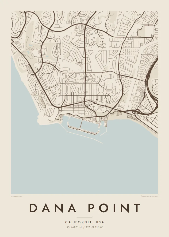
Long breakwaters enclose the harbour, creating a sheltered basin of marinas and boat slips that forms the most geometric shape on the coastline.
Pousita mape faigofie · United States
33.4670° N / 117.6981° W
A coastal city of headlands, a sheltered harbour and canyon streets, stepping down to the Pacific in Orange County.


Taone e tasi, lagona e lima
Pau te tapaki o se style ke lavea i luga i te puipui. E tutasi te tau o style takitasi — telotele mo faaki, e aunoa io me fai ki faila HD.
 Pixel tonu · faila lolomi 24 × 36″
Manino ki te lomiga
Tenei se 100% mai te faila lolomi tonu. Poster takitasi — telotele, faaki io me download — e faite i luga i a matou server i te 300 DPI, e oko atu ki 7,200 × 10,800 pixel, ko ala e maofio ei mo maiga vaega foliki i luga i te lolomi 24 × 36″.
I te pakitala


Te mape
Dana Point lies on the southern Orange County coast, between Laguna Beach and San Clemente. The map is shaped by the shoreline: rocky headlands, sandy coves and a large man-made harbour protected by long breakwaters. Streets follow the hills and canyons inland, curving around slopes and opening onto terraces that step down to the Pacific.
The city takes its name from Richard Henry Dana Jr., who described the headland in Two Years Before the Mast, his account of a voyage along the California coast in the 1830s. Today Dana Point Harbor is the centre of the city's waterfront, with marinas and boat slips laid out in neat geometric patterns inside the breakwater.
South of the harbour, San Juan Creek reaches the sea at Doheny State Beach, and the coast continues toward Capistrano Beach. Dana Point is also known for whale watching, with gray whales passing offshore during their migration. A Dana Point map poster shows this interplay of harbour, headland, beach and hillside neighbourhoods in clean detail.
Long breakwaters enclose the harbour, creating a sheltered basin of marinas and boat slips that forms the most geometric shape on the coastline.
Rocky promontories break up the shoreline, including the headland that gave the city its name, forming bold outlines against the sea.
Where San Juan Creek meets the ocean, the beach spreads in a broad sandy curve, adding a soft edge next to the harbour.
Fai ke fakatau ki a koe
Fakaopoopo se aso, se igoa io me se fuaiupu o koe, sui te sitaila, te lasi io me te tuuga.
Te preview fua e maulalo te malamalama kae iai se watermark. Poster telotele mo faila HD e faite i te 300 DPI, e oko atu ki 7,200 × 10,800 px, aunoa mo se watermark.
Kaia a Dana Point
Dana Point's coastline makes a striking map, with harbour, headlands and beaches all in one frame. It suits a beach house, a sailing enthusiast or anyone who has watched whales off this stretch of coast.
Add a title, subtitle and coordinates, and choose Classic black & white, Noir, Paper, Blueprint or Sand. The digital files are $9 for six sizes, including 18×24″ and 24×36″, with printed posters available too.
Otaina te poster Dana Point| Lasi o te lomiga | Manino | Faila |
|---|---|---|
| 30 × 40 cm11.8 × 15.7″ | 3,543 × 4,724 px | PNG · PDF |
| 29.7 × 42 cm (A3)11.7 × 16.5″ | 3,508 × 4,961 px | PNG · PDF |
| 42 × 59.4 cm (A2)16.5 × 23.4″ | 4,961 × 7,016 px | PNG · PDF |
| 45.7 × 61 cm18 × 24″ | 5,400 × 7,200 px | PNG · PDF |
| 50 × 70 cm19.7 × 27.6″ | 5,906 × 8,268 px | PNG · PDF |
| 61 × 91.4 cm24 × 36″ | 7,200 × 10,800 px | PNG · PDF |
Ke fakatusa, a te ata fakataitai fua e 900 px te lautele, mo te fakailoga kae mo lau lavea i luga i te komipiuta. A faila HD e oko ki te 8× te manino i itu katoa kae lomi faka‵lei i te lasi katoa o te pousita.
Filifili se style i te pito i luga o te itulau, kae filifili Poster Telotele — se lasi mo se faaki manafai e manako koe — io me Faila Digital HD. E tasi te sitepu mo te checkout, kae ka fakafou te itulau o tau ota i te taimi e mafai ei te totogi.
E telotele i luga o te pepa vali gali 200 gsm i se tasi mai lasi e ono, mai te 30 × 40 cm ki te 24 × 36″. E kamata te poster telotele mai i te $39, kae aofia ei te uta.
Ioe. Filifili se faaki lakau maoli i te kulokula, tea, oak maoli io me lakau pogisa. E oo mai ki tioata e se malepe kae toka ke tautau. E kamata te poster faaki mai i te $99, kae aofia ei te uta.
E tuku fua ki fenua e 60+. A poloaiga taki tasi e ta ne te tauhaga e latalata mai i a matou tauhaga ta i fenua e 30+, kae e masani o aunoa i aso galue e 3–7. E mafai o salasala te tulaga mo te sukesuke i lalo o Aku poloaiga. I nisi fenua e 2–5 vaiaso, kae i mea e seki tuku atu ei matou, e fakailoa atu e te mea tafaoga i mua o te totogi.
Auina mai se ata i loto i te 14 aso mai te taimi e oko ei kae ka toe telotele fua ne matou io me toe totogi atu tau tupe.
Ioe. I te editor i te itulau tenei, sui te ulutala, te ulutala lalo mo te laina o coordinate ki so se mea e manako koe, kae filifili se style mo se lasi. Oga telotele, faaki mo digital e faigana katoa i tau tusiga tonu.
Mo te $9 ka maua ne koe faila PNG 300 DPI mo PDF fakatoka lolomi i lasi e ono katoa, aunoa mo se watermark, ke lolomi i so se koga. E se mautinoa koe? Download muamua se preview fua e iai te watermark.
