Point Cruz
A small point projecting into the sea near the town centre and home to the port. It gives the otherwise straight coastline a single, distinctive notch.
Pousita mape faigofie · Solomon Islands
9.4333° S / 159.9500° E
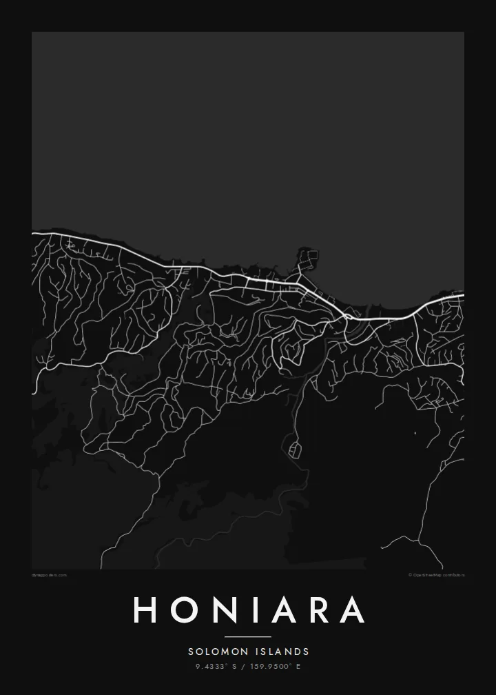
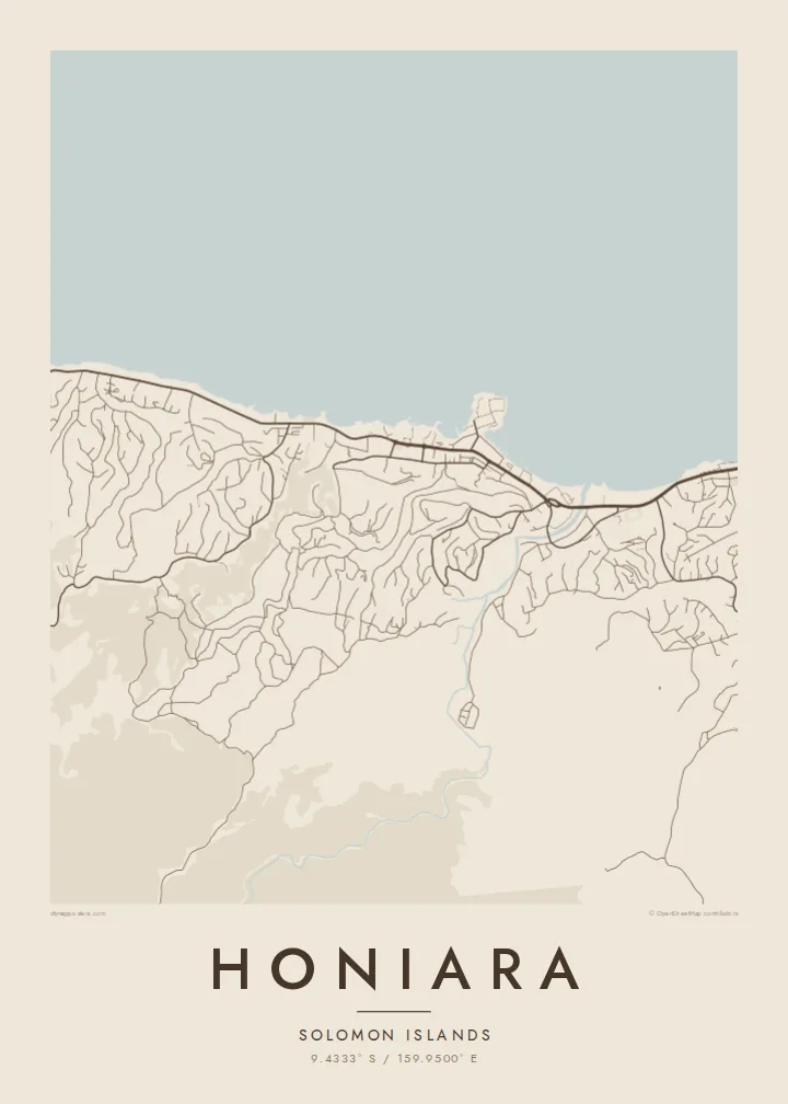
A long, thin town stretched along a northern shore, with a river mouth, a small point and steep ridges behind.



Taone e tasi, lagona e lima
Pau te tapaki o se style ke lavea i luga i te puipui. E tutasi te tau o style takitasi — telotele mo faaki, e aunoa io me fai ki faila HD.
 Pixel tonu · faila lolomi 24 × 36″
Manino ki te lomiga
Tenei se 100% mai te faila lolomi tonu. Poster takitasi — telotele, faaki io me download — e faite i luga i a matou server i te 300 DPI, e oko atu ki 7,200 × 10,800 pixel, ko ala e maofio ei mo maiga vaega foliki i luga i te lolomi 24 × 36″.
I te pakitala


Te mape
Honiara lies on the northern coast of Guadalcanal in the Solomon Islands, facing the stretch of water known as Iron Bottom Sound. Its map is strongly linear. The town follows the shoreline for several kilometres, with the main coastal road acting as a spine and neighbourhoods reaching up into the valleys and onto the ridges that rise quickly behind the coast.
Near the centre, the small projection of Point Cruz marks the port area, while the Mataniko River cuts through the town from the hills to the sea, dividing the map into clear sections. Inland, residential roads twist along ridgelines and around gullies. They give the southern edge of the drawing a branching, tree-like pattern that contrasts with the straight coastal strip.
Honiara grew from the base Allied forces built during the Guadalcanal campaign of the Second World War, and it replaced Tulagi as the capital after the war. The sound in front of it takes its name from the many ships sunk there in 1942 and 1943. A Honiara map poster shows a town defined by one long coastline and the hills that press against it.
A small point projecting into the sea near the town centre and home to the port. It gives the otherwise straight coastline a single, distinctive notch.
The river flows down from the hills and through the town to the coast. It is drawn as a winding line that splits Honiara into eastern and western halves.
Behind the coast, roads climb and branch along steep ridges and valleys, creating finger-like shapes that spread into the hills above the town.
Fai ke fakatau ki a koe
Fakaopoopo se aso, se igoa io me se fuaiupu o koe, sui te sitaila, te lasi io me te tuuga.
Te preview fua e maulalo te malamalama kae iai se watermark. Poster telotele mo faila HD e faite i te 300 DPI, e oko atu ki 7,200 × 10,800 px, aunoa mo se watermark.
Kaia a Honiara
Honiara is home to Solomon Islanders from many provinces and a temporary base for volunteers, aid workers and people tracing wartime history. A map of the town brings together sea, river and ridges in a composition that feels both specific and understated.
Give it a personal title and a subtitle with a date, a name or a province, and adjust the coordinates if you wish. Choose one of five styles, then download the HD files in six sizes or order a framed print.
Otaina te poster Honiara| Lasi o te lomiga | Manino | Faila |
|---|---|---|
| 30 × 40 cm11.8 × 15.7″ | 3,543 × 4,724 px | PNG · PDF |
| 29.7 × 42 cm (A3)11.7 × 16.5″ | 3,508 × 4,961 px | PNG · PDF |
| 42 × 59.4 cm (A2)16.5 × 23.4″ | 4,961 × 7,016 px | PNG · PDF |
| 45.7 × 61 cm18 × 24″ | 5,400 × 7,200 px | PNG · PDF |
| 50 × 70 cm19.7 × 27.6″ | 5,906 × 8,268 px | PNG · PDF |
| 61 × 91.4 cm24 × 36″ | 7,200 × 10,800 px | PNG · PDF |
Ke fakatusa, a te ata fakataitai fua e 900 px te lautele, mo te fakailoga kae mo lau lavea i luga i te komipiuta. A faila HD e oko ki te 8× te manino i itu katoa kae lomi faka‵lei i te lasi katoa o te pousita.
Filifili se style i te pito i luga o te itulau, kae filifili Poster Telotele — se lasi mo se faaki manafai e manako koe — io me Faila Digital HD. E tasi te sitepu mo te checkout, kae ka fakafou te itulau o tau ota i te taimi e mafai ei te totogi.
E telotele i luga o te pepa vali gali 200 gsm i se tasi mai lasi e ono, mai te 30 × 40 cm ki te 24 × 36″. E kamata te poster telotele mai i te $39, kae aofia ei te uta.
Ioe. Filifili se faaki lakau maoli i te kulokula, tea, oak maoli io me lakau pogisa. E oo mai ki tioata e se malepe kae toka ke tautau. E kamata te poster faaki mai i te $99, kae aofia ei te uta.
E tuku fua ki fenua e 60+. A poloaiga taki tasi e ta ne te tauhaga e latalata mai i a matou tauhaga ta i fenua e 30+, kae e masani o aunoa i aso galue e 3–7. E mafai o salasala te tulaga mo te sukesuke i lalo o Aku poloaiga. I nisi fenua e 2–5 vaiaso, kae i mea e seki tuku atu ei matou, e fakailoa atu e te mea tafaoga i mua o te totogi.
Auina mai se ata i loto i te 14 aso mai te taimi e oko ei kae ka toe telotele fua ne matou io me toe totogi atu tau tupe.
Ioe. I te editor i te itulau tenei, sui te ulutala, te ulutala lalo mo te laina o coordinate ki so se mea e manako koe, kae filifili se style mo se lasi. Oga telotele, faaki mo digital e faigana katoa i tau tusiga tonu.
Mo te $9 ka maua ne koe faila PNG 300 DPI mo PDF fakatoka lolomi i lasi e ono katoa, aunoa mo se watermark, ke lolomi i so se koga. E se mautinoa koe? Download muamua se preview fua e iai te watermark.
Koga pili
