Lake Timsah
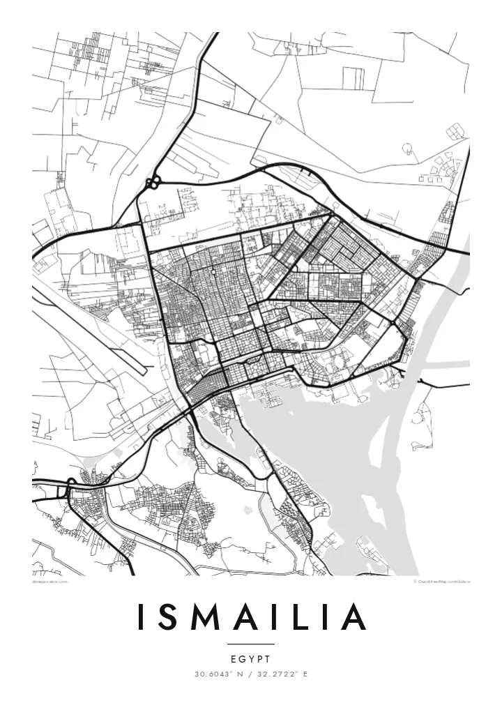
The lake forms a broad open shape at the edge of the city, with the Suez Canal passing through it. Beaches and gardens line the shore facing the water.
Pousita mape faigofie · Egypt
30.6043° N / 32.2722° E
A canal town laid out on the shore of Lake Timsah, halfway along the Suez Canal, with a gridded garden quarter.


Taone e tasi, lagona e lima
Pau te tapaki o se style ke lavea i luga i te puipui. E tutasi te tau o style takitasi — telotele mo faaki, e aunoa io me fai ki faila HD.
 Pixel tonu · faila lolomi 24 × 36″
Manino ki te lomiga
Tenei se 100% mai te faila lolomi tonu. Poster takitasi — telotele, faaki io me download — e faite i luga i a matou server i te 300 DPI, e oko atu ki 7,200 × 10,800 pixel, ko ala e maofio ei mo maiga vaega foliki i luga i te lolomi 24 × 36″.
I te pakitala


Te mape
Ismailia was founded in 1863 as a base for the construction of the Suez Canal and named after Khedive Ismail. It stands on the north-western shore of Lake Timsah, roughly midway between Port Said and Suez, and the map is dominated by water: the lake, the straight line of the canal running through it, and the freshwater Ismailia Canal bringing Nile water across the desert.
The original town was planned in a clear grid, with a European quarter of broad streets, villas and gardens that still gives Ismailia a greener, more orderly look than many Egyptian cities. The Suez Canal Authority has its headquarters here, and the waterfront toward the lake is lined with public gardens and small beaches.
Beyond the grid, newer districts spread along the roads to Cairo, Port Said and Suez, and the desert presses close on the edges of the map. An Ismailia map poster brings these layers together: a nineteenth-century planned town, a lake that the canal passes through, and a thin green line of irrigation cutting across the sand.
The lake forms a broad open shape at the edge of the city, with the Suez Canal passing through it. Beaches and gardens line the shore facing the water.
The original planned district has a regular grid of wide streets and villas set among trees, one of the clearest examples of nineteenth-century town planning in Egypt.
A freshwater canal from the Nile reaches the city from the west, a thin line of water and green fields crossing otherwise empty desert on the map.
Fai ke fakatau ki a koe
Fakaopoopo se aso, se igoa io me se fuaiupu o koe, sui te sitaila, te lasi io me te tuuga.
Te preview fua e maulalo te malamalama kae iai se watermark. Poster telotele mo faila HD e faite i te 300 DPI, e oko atu ki 7,200 × 10,800 px, aunoa mo se watermark.
Kaia a Ismailia
Ismailia is a city many Egyptians associate with calm streets, the lake and the ships passing along the canal. The map works as a keepsake for residents, for people who studied or served there, and for anyone fascinated by the history of the canal.
Personalise the title, subtitle and coordinates line, then choose from five styles: Classic black & white, Noir, Paper, Blueprint or Sand. Blueprint suits the engineering story of the canal particularly well. Printed posters come on matte paper with an optional wooden frame.
Otaina te poster Ismailia| Lasi o te lomiga | Manino | Faila |
|---|---|---|
| 30 × 40 cm11.8 × 15.7″ | 3,543 × 4,724 px | PNG · PDF |
| 29.7 × 42 cm (A3)11.7 × 16.5″ | 3,508 × 4,961 px | PNG · PDF |
| 42 × 59.4 cm (A2)16.5 × 23.4″ | 4,961 × 7,016 px | PNG · PDF |
| 45.7 × 61 cm18 × 24″ | 5,400 × 7,200 px | PNG · PDF |
| 50 × 70 cm19.7 × 27.6″ | 5,906 × 8,268 px | PNG · PDF |
| 61 × 91.4 cm24 × 36″ | 7,200 × 10,800 px | PNG · PDF |
Ke fakatusa, a te ata fakataitai fua e 900 px te lautele, mo te fakailoga kae mo lau lavea i luga i te komipiuta. A faila HD e oko ki te 8× te manino i itu katoa kae lomi faka‵lei i te lasi katoa o te pousita.
Filifili se style i te pito i luga o te itulau, kae filifili Poster Telotele — se lasi mo se faaki manafai e manako koe — io me Faila Digital HD. E tasi te sitepu mo te checkout, kae ka fakafou te itulau o tau ota i te taimi e mafai ei te totogi.
E telotele i luga o te pepa vali gali 200 gsm i se tasi mai lasi e ono, mai te 30 × 40 cm ki te 24 × 36″. E kamata te poster telotele mai i te $39, kae aofia ei te uta.
Ioe. Filifili se faaki lakau maoli i te kulokula, tea, oak maoli io me lakau pogisa. E oo mai ki tioata e se malepe kae toka ke tautau. E kamata te poster faaki mai i te $99, kae aofia ei te uta.
E tuku fua ki fenua e 60+. A poloaiga taki tasi e ta ne te tauhaga e latalata mai i a matou tauhaga ta i fenua e 30+, kae e masani o aunoa i aso galue e 3–7. E mafai o salasala te tulaga mo te sukesuke i lalo o Aku poloaiga. I nisi fenua e 2–5 vaiaso, kae i mea e seki tuku atu ei matou, e fakailoa atu e te mea tafaoga i mua o te totogi.
Auina mai se ata i loto i te 14 aso mai te taimi e oko ei kae ka toe telotele fua ne matou io me toe totogi atu tau tupe.
Ioe. I te editor i te itulau tenei, sui te ulutala, te ulutala lalo mo te laina o coordinate ki so se mea e manako koe, kae filifili se style mo se lasi. Oga telotele, faaki mo digital e faigana katoa i tau tusiga tonu.
Mo te $9 ka maua ne koe faila PNG 300 DPI mo PDF fakatoka lolomi i lasi e ono katoa, aunoa mo se watermark, ke lolomi i so se koga. E se mautinoa koe? Download muamua se preview fua e iai te watermark.
