Colonial grid
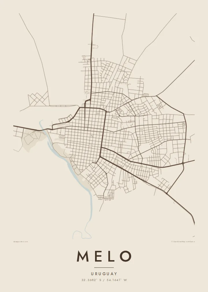
Square blocks and straight streets cover the city in a regular pattern, arranged around central plazas in the manner of many Uruguayan towns.
Pousita mape faigofie · Uruguay
32.3682° S / 54.1641° W
A regular colonial grid in the rolling grasslands of northeast Uruguay, bordered by a winding stream


Taone e tasi, lagona e lima
Pau te tapaki o se style ke lavea i luga i te puipui. E tutasi te tau o style takitasi — telotele mo faaki, e aunoa io me fai ki faila HD.
 Pixel tonu · faila lolomi 24 × 36″
Manino ki te lomiga
Tenei se 100% mai te faila lolomi tonu. Poster takitasi — telotele, faaki io me download — e faite i luga i a matou server i te 300 DPI, e oko atu ki 7,200 × 10,800 pixel, ko ala e maofio ei mo maiga vaega foliki i luga i te lolomi 24 × 36″.
I te pakitala


Te mape
Melo is the capital of Cerro Largo department in northeastern Uruguay, not far from the border with Brazil. Founded in the late eighteenth century, it follows the regular grid common to towns of the region: square blocks arranged around central plazas, with straight streets running out toward the edges of the city.
The Arroyo Conventos winds along the town, and its curving course breaks the otherwise strict geometry of the street plan. Beyond the built-up area, the map opens onto the gently rolling grasslands of the Uruguayan interior, cattle country crossed by roads leading toward the border and toward Montevideo far to the south.
A Melo map poster is a clear portrait of a planned town on open land. In black and white the grid reads as a precise pattern of squares, the stream adds a single soft curve, and the pale countryside around it gives the composition room. It is orderly and restful, much like the region itself.
Square blocks and straight streets cover the city in a regular pattern, arranged around central plazas in the manner of many Uruguayan towns.
The stream curves along the town, a natural line that softens the grid and provides open, green space along its banks.
Beyond the city the map opens onto rolling pasture, crossed by a few long roads heading toward Brazil and the rest of Uruguay.
Fai ke fakatau ki a koe
Fakaopoopo se aso, se igoa io me se fuaiupu o koe, sui te sitaila, te lasi io me te tuuga.
Te preview fua e maulalo te malamalama kae iai se watermark. Poster telotele mo faila HD e faite i te 300 DPI, e oko atu ki 7,200 × 10,800 px, aunoa mo se watermark.
Kaia a Melo
A map of Melo is a fitting piece for people from Cerro Largo, for families with roots in the northeast and for anyone who enjoys the precision of a planned town. The grid makes a crisp, graphic image.
You can edit the title, subtitle and coordinates line and choose from five styles, including Paper and Noir. HD files cost $9 in six print sizes, and printed posters come on matte paper with an optional wooden frame.
Otaina te poster Melo| Lasi o te lomiga | Manino | Faila |
|---|---|---|
| 30 × 40 cm11.8 × 15.7″ | 3,543 × 4,724 px | PNG · PDF |
| 29.7 × 42 cm (A3)11.7 × 16.5″ | 3,508 × 4,961 px | PNG · PDF |
| 42 × 59.4 cm (A2)16.5 × 23.4″ | 4,961 × 7,016 px | PNG · PDF |
| 45.7 × 61 cm18 × 24″ | 5,400 × 7,200 px | PNG · PDF |
| 50 × 70 cm19.7 × 27.6″ | 5,906 × 8,268 px | PNG · PDF |
| 61 × 91.4 cm24 × 36″ | 7,200 × 10,800 px | PNG · PDF |
Ke fakatusa, a te ata fakataitai fua e 900 px te lautele, mo te fakailoga kae mo lau lavea i luga i te komipiuta. A faila HD e oko ki te 8× te manino i itu katoa kae lomi faka‵lei i te lasi katoa o te pousita.
Filifili se style i te pito i luga o te itulau, kae filifili Poster Telotele — se lasi mo se faaki manafai e manako koe — io me Faila Digital HD. E tasi te sitepu mo te checkout, kae ka fakafou te itulau o tau ota i te taimi e mafai ei te totogi.
E telotele i luga o te pepa vali gali 200 gsm i se tasi mai lasi e ono, mai te 30 × 40 cm ki te 24 × 36″. E kamata te poster telotele mai i te $39, kae aofia ei te uta.
Ioe. Filifili se faaki lakau maoli i te kulokula, tea, oak maoli io me lakau pogisa. E oo mai ki tioata e se malepe kae toka ke tautau. E kamata te poster faaki mai i te $99, kae aofia ei te uta.
E tuku fua ki fenua e 60+. A poloaiga taki tasi e ta ne te tauhaga e latalata mai i a matou tauhaga ta i fenua e 30+, kae e masani o aunoa i aso galue e 3–7. E mafai o salasala te tulaga mo te sukesuke i lalo o Aku poloaiga. I nisi fenua e 2–5 vaiaso, kae i mea e seki tuku atu ei matou, e fakailoa atu e te mea tafaoga i mua o te totogi.
Auina mai se ata i loto i te 14 aso mai te taimi e oko ei kae ka toe telotele fua ne matou io me toe totogi atu tau tupe.
Ioe. I te editor i te itulau tenei, sui te ulutala, te ulutala lalo mo te laina o coordinate ki so se mea e manako koe, kae filifili se style mo se lasi. Oga telotele, faaki mo digital e faigana katoa i tau tusiga tonu.
Mo te $9 ka maua ne koe faila PNG 300 DPI mo PDF fakatoka lolomi i lasi e ono katoa, aunoa mo se watermark, ke lolomi i so se koga. E se mautinoa koe? Download muamua se preview fua e iai te watermark.
