Natori River mouth
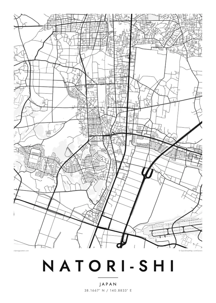
The river reaches the Pacific at Yuriage. Its final bend and the rebuilt harbour district form the most detailed part of the coastline on the map.
Pousita mape faigofie · Japan
38.1667° N / 140.8833° E
A flat coastal city south of Sendai, stretching from inland neighbourhoods across rice fields to the port of Yuriage on the Pacific.


Taone e tasi, lagona e lima
Pau te tapaki o se style ke lavea i luga i te puipui. E tutasi te tau o style takitasi — telotele mo faaki, e aunoa io me fai ki faila HD.
 Pixel tonu · faila lolomi 24 × 36″
Manino ki te lomiga
Tenei se 100% mai te faila lolomi tonu. Poster takitasi — telotele, faaki io me download — e faite i luga i a matou server i te 300 DPI, e oko atu ki 7,200 × 10,800 pixel, ko ala e maofio ei mo maiga vaega foliki i luga i te lolomi 24 × 36″.
I te pakitala


Te mape
Natori lies directly south of Sendai in Miyagi Prefecture, on the broad coastal plain along Sendai Bay. The Natori River forms much of its boundary with Sendai. On a map the city reads as a band of land stretching from low hills and suburbs in the west, across farmland, to a straight Pacific shoreline in the east.
The coastal district of Yuriage, at the mouth of the river, was devastated by the tsunami of March 2011 and has since been rebuilt on raised ground. Sendai Airport lies at the city's southern edge, shared with neighbouring Iwanuma, its runway a clean straight line near the coast. Rail and road links have made Natori a commuter city for Sendai.
A Natori-shi map poster captures a place defined by its plain: rectangular paddy fields, a river winding to the sea, a straight coastline and a runway. For people with family roots in Yuriage, or memories of the coast before and after 2011, it can be a deeply personal piece to hang at home.
The river reaches the Pacific at Yuriage. Its final bend and the rebuilt harbour district form the most detailed part of the coastline on the map.
The airport sits on the coastal plain at the city's southern edge. Its long runway is a crisp geometric line among the fields.
Between the town centre and the sea, rice fields in regular rectangles cover the land. They give the eastern half of the poster a quiet, even texture.
Fai ke fakatau ki a koe
Fakaopoopo se aso, se igoa io me se fuaiupu o koe, sui te sitaila, te lasi io me te tuuga.
Te preview fua e maulalo te malamalama kae iai se watermark. Poster telotele mo faila HD e faite i te 300 DPI, e oko atu ki 7,200 × 10,800 px, aunoa mo se watermark.
Kaia a Natori-shi
Natori is home to many who commute to Sendai, and to families who have lived on the coast for generations. A map of the city holds both the newer neighbourhoods and the rebuilt shoreline in one quiet frame.
Choose a title and subtitle, perhaps the name of a district and a date, and edit the coordinates. Five styles are available, from Classic black & white to Sand. Download 300 DPI PNG and PDF files in six sizes for $9.
Otaina te poster Natori-shi| Lasi o te lomiga | Manino | Faila |
|---|---|---|
| 30 × 40 cm11.8 × 15.7″ | 3,543 × 4,724 px | PNG · PDF |
| 29.7 × 42 cm (A3)11.7 × 16.5″ | 3,508 × 4,961 px | PNG · PDF |
| 42 × 59.4 cm (A2)16.5 × 23.4″ | 4,961 × 7,016 px | PNG · PDF |
| 45.7 × 61 cm18 × 24″ | 5,400 × 7,200 px | PNG · PDF |
| 50 × 70 cm19.7 × 27.6″ | 5,906 × 8,268 px | PNG · PDF |
| 61 × 91.4 cm24 × 36″ | 7,200 × 10,800 px | PNG · PDF |
Ke fakatusa, a te ata fakataitai fua e 900 px te lautele, mo te fakailoga kae mo lau lavea i luga i te komipiuta. A faila HD e oko ki te 8× te manino i itu katoa kae lomi faka‵lei i te lasi katoa o te pousita.
Filifili se style i te pito i luga o te itulau, kae filifili Poster Telotele — se lasi mo se faaki manafai e manako koe — io me Faila Digital HD. E tasi te sitepu mo te checkout, kae ka fakafou te itulau o tau ota i te taimi e mafai ei te totogi.
E telotele i luga o te pepa vali gali 200 gsm i se tasi mai lasi e ono, mai te 30 × 40 cm ki te 24 × 36″. E kamata te poster telotele mai i te $39, kae aofia ei te uta.
Ioe. Filifili se faaki lakau maoli i te kulokula, tea, oak maoli io me lakau pogisa. E oo mai ki tioata e se malepe kae toka ke tautau. E kamata te poster faaki mai i te $99, kae aofia ei te uta.
E tuku fua ki fenua e 60+. A poloaiga taki tasi e ta ne te tauhaga e latalata mai i a matou tauhaga ta i fenua e 30+, kae e masani o aunoa i aso galue e 3–7. E mafai o salasala te tulaga mo te sukesuke i lalo o Aku poloaiga. I nisi fenua e 2–5 vaiaso, kae i mea e seki tuku atu ei matou, e fakailoa atu e te mea tafaoga i mua o te totogi.
Auina mai se ata i loto i te 14 aso mai te taimi e oko ei kae ka toe telotele fua ne matou io me toe totogi atu tau tupe.
Ioe. I te editor i te itulau tenei, sui te ulutala, te ulutala lalo mo te laina o coordinate ki so se mea e manako koe, kae filifili se style mo se lasi. Oga telotele, faaki mo digital e faigana katoa i tau tusiga tonu.
Mo te $9 ka maua ne koe faila PNG 300 DPI mo PDF fakatoka lolomi i lasi e ono katoa, aunoa mo se watermark, ke lolomi i so se koga. E se mautinoa koe? Download muamua se preview fua e iai te watermark.
