The fish quay
A cluster of jetties, sheds and moorings on the riverbank, where the town's long fishing tradition still shapes the shoreline into a dense, irregular edge of short piers.
Pousita mape faigofie · United Kingdom
55.0165° N / 1.4492° W
A riverside town on the north bank of the Tyne, where quays and a planned upper grid face the estuary mouth




Taone e tasi, lagona e lima
Pau te tapaki o se style ke lavea i luga i te puipui. E tutasi te tau o style takitasi — telotele mo faaki, e aunoa io me fai ki faila HD.
 Pixel tonu · faila lolomi 24 × 36″
Manino ki te lomiga
Tenei se 100% mai te faila lolomi tonu. Poster takitasi — telotele, faaki io me download — e faite i luga i a matou server i te 300 DPI, e oko atu ki 7,200 × 10,800 pixel, ko ala e maofio ei mo maiga vaega foliki i luga i te lolomi 24 × 36″.
I te pakitala


Te mape
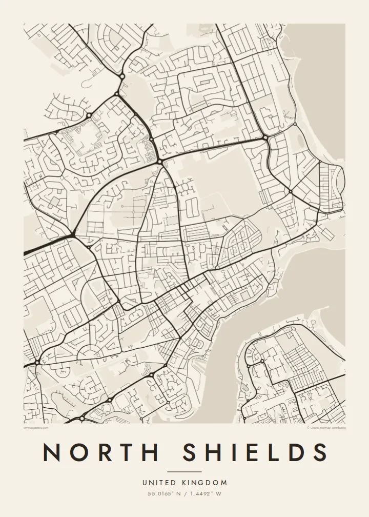
North Shields sits on the north bank of the River Tyne, close to where the estuary opens into the North Sea. From above, the town splits into two levels: a tight strip of streets and quays along the water, and a more regular upper town laid out on the bank above it. Steps and steep lanes link the two, and on a map they show as short, abrupt connectors.
The fish quay remains the town's best-known edge, a working waterfront of sheds, jetties and moorings that gives the shoreline a jagged, busy outline. Further upriver the Royal Quays area turns former dock land into marina basins and the terminal for ferries across the North Sea. Across the water lies South Shields, linked by a small passenger ferry, so the river works as a street rather than a border.
A North Shields map poster captures that contrast between the irregular riverbank and the orderly terraces above it. The Tyne takes up a broad band of the frame, its curves leading the eye towards the harbour piers at the river mouth. Inland, rows of terraced housing fill the upper part of the sheet with fine, parallel lines, so the town reads as layered and closely tied to the sea.
A cluster of jetties, sheds and moorings on the riverbank, where the town's long fishing tradition still shapes the shoreline into a dense, irregular edge of short piers.
A steep bank separates the old waterside streets from the planned town above, and on the map the change shows as a sudden switch from crooked lanes to straight terraces.
A short passenger ferry crosses to South Shields, and the river itself becomes the widest open space on the map, framed by quays on both banks.
Fai ke fakatau ki a koe
Fakaopoopo se aso, se igoa io me se fuaiupu o koe, sui te sitaila, te lasi io me te tuuga.
Te preview fua e maulalo te malamalama kae iai se watermark. Poster telotele mo faila HD e faite i te 300 DPI, e oko atu ki 7,200 × 10,800 px, aunoa mo se watermark.
Kaia a North Shields
For people who grew up on Tyneside, worked on the river or crossed on the ferry, the map traces a place defined by water and weather. It is a quiet reminder of the quay, the bank and the way the town faces the sea.
You can personalise the title, subtitle and coordinates line, adding a family name or a date that matters. Choose from Classic black & white, Noir, Paper, Blueprint or Sand, and order a printed poster or download the $9 HD files.
Otaina te poster North Shields| Lasi o te lomiga | Manino | Faila |
|---|---|---|
| 30 × 40 cm11.8 × 15.7″ | 3,543 × 4,724 px | PNG · PDF |
| 29.7 × 42 cm (A3)11.7 × 16.5″ | 3,508 × 4,961 px | PNG · PDF |
| 42 × 59.4 cm (A2)16.5 × 23.4″ | 4,961 × 7,016 px | PNG · PDF |
| 45.7 × 61 cm18 × 24″ | 5,400 × 7,200 px | PNG · PDF |
| 50 × 70 cm19.7 × 27.6″ | 5,906 × 8,268 px | PNG · PDF |
| 61 × 91.4 cm24 × 36″ | 7,200 × 10,800 px | PNG · PDF |
Ke fakatusa, a te ata fakataitai fua e 900 px te lautele, mo te fakailoga kae mo lau lavea i luga i te komipiuta. A faila HD e oko ki te 8× te manino i itu katoa kae lomi faka‵lei i te lasi katoa o te pousita.
Filifili se style i te pito i luga o te itulau, kae filifili Poster Telotele — se lasi mo se faaki manafai e manako koe — io me Faila Digital HD. E tasi te sitepu mo te checkout, kae ka fakafou te itulau o tau ota i te taimi e mafai ei te totogi.
E telotele i luga o te pepa vali gali 200 gsm i se tasi mai lasi e ono, mai te 30 × 40 cm ki te 24 × 36″. E kamata te poster telotele mai i te $39, kae aofia ei te uta.
Ioe. Filifili se faaki lakau maoli i te kulokula, tea, oak maoli io me lakau pogisa. E oo mai ki tioata e se malepe kae toka ke tautau. E kamata te poster faaki mai i te $99, kae aofia ei te uta.
E tuku fua ki fenua e 60+. A poloaiga taki tasi e ta ne te tauhaga e latalata mai i a matou tauhaga ta i fenua e 30+, kae e masani o aunoa i aso galue e 3–7. E mafai o salasala te tulaga mo te sukesuke i lalo o Aku poloaiga. I nisi fenua e 2–5 vaiaso, kae i mea e seki tuku atu ei matou, e fakailoa atu e te mea tafaoga i mua o te totogi.
Auina mai se ata i loto i te 14 aso mai te taimi e oko ei kae ka toe telotele fua ne matou io me toe totogi atu tau tupe.
Ioe. I te editor i te itulau tenei, sui te ulutala, te ulutala lalo mo te laina o coordinate ki so se mea e manako koe, kae filifili se style mo se lasi. Oga telotele, faaki mo digital e faigana katoa i tau tusiga tonu.
Mo te $9 ka maua ne koe faila PNG 300 DPI mo PDF fakatoka lolomi i lasi e ono katoa, aunoa mo se watermark, ke lolomi i so se koga. E se mautinoa koe? Download muamua se preview fua e iai te watermark.
