Strait of Magellan
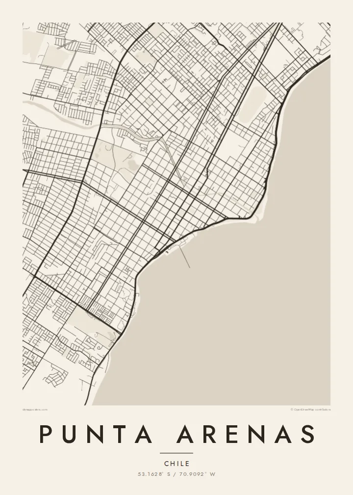
The city's whole eastern side faces the strait. On the poster it appears as a broad open plane, with the city running along one shore and Tierra del Fuego across the water.
Pousita mape faigofie · Chile
53.1628° S / 70.9092° W
A windswept grid on the Strait of Magellan, where straight streets run down to the water facing Tierra del Fuego




Taone e tasi, lagona e lima
Pau te tapaki o se style ke lavea i luga i te puipui. E tutasi te tau o style takitasi — telotele mo faaki, e aunoa io me fai ki faila HD.
 Pixel tonu · faila lolomi 24 × 36″
Manino ki te lomiga
Tenei se 100% mai te faila lolomi tonu. Poster takitasi — telotele, faaki io me download — e faite i luga i a matou server i te 300 DPI, e oko atu ki 7,200 × 10,800 pixel, ko ala e maofio ei mo maiga vaega foliki i luga i te lolomi 24 × 36″.
I te pakitala


Te mape
Punta Arenas stretches along the western shore of the Strait of Magellan and is one of the southernmost cities in the world. From above, it is a disciplined grid of straight streets and square blocks. The grid runs from the coastline up gentle slopes toward the hills and the Patagonian steppe. The Costanera road follows the shore, and to the east lies the open water of the strait, with Tierra del Fuego on the far side.
The city was founded in 1848 as a Chilean outpost. It prospered as a port on the route between the Atlantic and Pacific before the Panama Canal opened, and later as a centre of the sheep-farming trade. Its central square, Plaza Muñoz Gamero, is laid out around a monument to Magellan. A Punta Arenas map poster shows the plaza at the heart of a regular plan that seems built to hold firm against the wind.
In black and white, the contrast between land and sea is stark. The dense grid stops at a clean coastline, and the strait fills the rest of the frame as a single calm field. Small rivers and ravines come down from the hills and break into the rows of blocks. The result is a graphic image of a city at the edge of the continent.
The city's whole eastern side faces the strait. On the poster it appears as a broad open plane, with the city running along one shore and Tierra del Fuego across the water.
The main square sits at the centre of the grid, surrounded by regular blocks. The Magellan monument stands there, and the square is the anchor of the whole plan.
Straight streets climb from the coast toward the western hills in long parallel rows. They give the city its orderly, almost drafted look against the open landscape.
Fai ke fakatau ki a koe
Fakaopoopo se aso, se igoa io me se fuaiupu o koe, sui te sitaila, te lasi io me te tuuga.
Te preview fua e maulalo te malamalama kae iai se watermark. Poster telotele mo faila HD e faite i te 300 DPI, e oko atu ki 7,200 × 10,800 px, aunoa mo se watermark.
Kaia a Punta Arenas
Punta Arenas is often a gateway to Torres del Paine, Antarctic voyages and Tierra del Fuego, so its map works as a keepsake of a journey to the far south. For residents, it is a striking portrait of a city defined by its coastline.
You can personalise the title, subtitle and coordinates line, for example with an expedition date or a family name. Choose from five styles: Classic black & white, Noir, Paper, Blueprint and Sand. Blueprint suits the seafaring history of the port. Order it as a digital file or as a printed poster.
Otaina te poster Punta Arenas| Lasi o te lomiga | Manino | Faila |
|---|---|---|
| 30 × 40 cm11.8 × 15.7″ | 3,543 × 4,724 px | PNG · PDF |
| 29.7 × 42 cm (A3)11.7 × 16.5″ | 3,508 × 4,961 px | PNG · PDF |
| 42 × 59.4 cm (A2)16.5 × 23.4″ | 4,961 × 7,016 px | PNG · PDF |
| 45.7 × 61 cm18 × 24″ | 5,400 × 7,200 px | PNG · PDF |
| 50 × 70 cm19.7 × 27.6″ | 5,906 × 8,268 px | PNG · PDF |
| 61 × 91.4 cm24 × 36″ | 7,200 × 10,800 px | PNG · PDF |
Ke fakatusa, a te ata fakataitai fua e 900 px te lautele, mo te fakailoga kae mo lau lavea i luga i te komipiuta. A faila HD e oko ki te 8× te manino i itu katoa kae lomi faka‵lei i te lasi katoa o te pousita.
Filifili se style i te pito i luga o te itulau, kae filifili Poster Telotele — se lasi mo se faaki manafai e manako koe — io me Faila Digital HD. E tasi te sitepu mo te checkout, kae ka fakafou te itulau o tau ota i te taimi e mafai ei te totogi.
E telotele i luga o te pepa vali gali 200 gsm i se tasi mai lasi e ono, mai te 30 × 40 cm ki te 24 × 36″. E kamata te poster telotele mai i te $39, kae aofia ei te uta.
Ioe. Filifili se faaki lakau maoli i te kulokula, tea, oak maoli io me lakau pogisa. E oo mai ki tioata e se malepe kae toka ke tautau. E kamata te poster faaki mai i te $99, kae aofia ei te uta.
E tuku fua ki fenua e 60+. A poloaiga taki tasi e ta ne te tauhaga e latalata mai i a matou tauhaga ta i fenua e 30+, kae e masani o aunoa i aso galue e 3–7. E mafai o salasala te tulaga mo te sukesuke i lalo o Aku poloaiga. I nisi fenua e 2–5 vaiaso, kae i mea e seki tuku atu ei matou, e fakailoa atu e te mea tafaoga i mua o te totogi.
Auina mai se ata i loto i te 14 aso mai te taimi e oko ei kae ka toe telotele fua ne matou io me toe totogi atu tau tupe.
Ioe. I te editor i te itulau tenei, sui te ulutala, te ulutala lalo mo te laina o coordinate ki so se mea e manako koe, kae filifili se style mo se lasi. Oga telotele, faaki mo digital e faigana katoa i tau tusiga tonu.
Mo te $9 ka maua ne koe faila PNG 300 DPI mo PDF fakatoka lolomi i lasi e ono katoa, aunoa mo se watermark, ke lolomi i so se koga. E se mautinoa koe? Download muamua se preview fua e iai te watermark.
Koga pili
