Churni river
The Churni bends past the town in wide, unhurried curves. This single strong water line gives the composition its natural edge and contrasts with the straighter roads.
Pousita mape faigofie · India
23.1762° N / 88.5667° E
A Nadia district railway town on the Churni river, its streets gathered along the tracks and the gentle bends of the water.



Taone e tasi, lagona e lima
Pau te tapaki o se style ke lavea i luga i te puipui. E tutasi te tau o style takitasi — telotele mo faaki, e aunoa io me fai ki faila HD.
 Pixel tonu · faila lolomi 24 × 36″
Manino ki te lomiga
Tenei se 100% mai te faila lolomi tonu. Poster takitasi — telotele, faaki io me download — e faite i luga i a matou server i te 300 DPI, e oko atu ki 7,200 × 10,800 pixel, ko ala e maofio ei mo maiga vaega foliki i luga i te lolomi 24 × 36″.
I te pakitala


Te mape
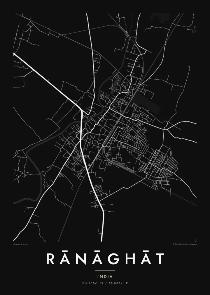
Rānāghāt lies in Nadia district in West Bengal, north of Kolkata on the flat, well-watered plain of the lower Ganges delta. The Churni river runs past the town in slow curves, and the land around it is laid out in fields, ponds and village clusters. On a map the town appears as a concentrated patch of streets set within that softer rural pattern.
The town is best known as a railway junction, where lines of the Sealdah suburban network branch toward different parts of the district and beyond. The tracks are among the clearest features of the plan: straight lines cutting through a street network that is otherwise irregular and closely built. Residential lanes fill the spaces between the railway, the main roads and the river.
A Rānāghāt map poster turns this into a clean, readable image: the river as a meandering band, the railway as a set of straight strokes, and the town's dense lanes filling the space between. It is a thoughtful piece for commuters who know the junction well, for families from Nadia, and for anyone attached to the everyday landscape of Bengal.
The Churni bends past the town in wide, unhurried curves. This single strong water line gives the composition its natural edge and contrasts with the straighter roads.
Rail lines meet and diverge at Rānāghāt. They are drawn as long straight strokes that cut across the street network and show clearly why the town grew where it did.
Around the town the map dissolves into fields, ponds and scattered settlements typical of the Bengal delta. This light, open texture frames the denser urban centre.
Fai ke fakatau ki a koe
Fakaopoopo se aso, se igoa io me se fuaiupu o koe, sui te sitaila, te lasi io me te tuuga.
Te preview fua e maulalo te malamalama kae iai se watermark. Poster telotele mo faila HD e faite i te 300 DPI, e oko atu ki 7,200 × 10,800 px, aunoa mo se watermark.
Kaia a Rānāghāt
Many people know Rānāghāt through daily trains, family homes or school years, and a map of the town holds those routines in one image. Personalise the title and subtitle, perhaps with a family name or year, and keep the coordinates line as a precise marker.
Pick one of five styles, Classic black & white, Noir, Paper, Blueprint or Sand, and preview it free at 900 px with a watermark. The full $9 download gives six print sizes as 300 DPI PNG and print-ready PDF. You can also order a matte printed poster instead.
Otaina te poster Rānāghāt| Lasi o te lomiga | Manino | Faila |
|---|---|---|
| 30 × 40 cm11.8 × 15.7″ | 3,543 × 4,724 px | PNG · PDF |
| 29.7 × 42 cm (A3)11.7 × 16.5″ | 3,508 × 4,961 px | PNG · PDF |
| 42 × 59.4 cm (A2)16.5 × 23.4″ | 4,961 × 7,016 px | PNG · PDF |
| 45.7 × 61 cm18 × 24″ | 5,400 × 7,200 px | PNG · PDF |
| 50 × 70 cm19.7 × 27.6″ | 5,906 × 8,268 px | PNG · PDF |
| 61 × 91.4 cm24 × 36″ | 7,200 × 10,800 px | PNG · PDF |
Ke fakatusa, a te ata fakataitai fua e 900 px te lautele, mo te fakailoga kae mo lau lavea i luga i te komipiuta. A faila HD e oko ki te 8× te manino i itu katoa kae lomi faka‵lei i te lasi katoa o te pousita.
Filifili se style i te pito i luga o te itulau, kae filifili Poster Telotele — se lasi mo se faaki manafai e manako koe — io me Faila Digital HD. E tasi te sitepu mo te checkout, kae ka fakafou te itulau o tau ota i te taimi e mafai ei te totogi.
E telotele i luga o te pepa vali gali 200 gsm i se tasi mai lasi e ono, mai te 30 × 40 cm ki te 24 × 36″. E kamata te poster telotele mai i te $39, kae aofia ei te uta.
Ioe. Filifili se faaki lakau maoli i te kulokula, tea, oak maoli io me lakau pogisa. E oo mai ki tioata e se malepe kae toka ke tautau. E kamata te poster faaki mai i te $99, kae aofia ei te uta.
E saoloto te ave atu i te lalolagi katoa. Ko poster taki tasi e ta ne te taugasoa ta e ofi mai i fenua e 30+, kae e masani o oko atu i aso galue e 3–7. E mafai o mata ki te tulaga mo te sukesuke i lalo o Aku Poloaiga. E isi fenua e 2–5 vaiaso, kae i mea e seki ave atu ki ei, e fakailoa atu ne te saite i mua o te totogi.
Auina mai se ata i loto i te 14 aso mai te taimi e oko ei kae ka toe telotele fua ne matou io me toe totogi atu tau tupe.
Ioe. I te editor i te itulau tenei, sui te ulutala, te ulutala lalo mo te laina o coordinate ki so se mea e manako koe, kae filifili se style mo se lasi. Oga telotele, faaki mo digital e faigana katoa i tau tusiga tonu.
Mo te $9 ka maua ne koe faila PNG 300 DPI mo PDF fakatoka lolomi i lasi e ono katoa, aunoa mo se watermark, ke lolomi i so se koga. E se mautinoa koe? Download muamua se preview fua e iai te watermark.
