The estuary
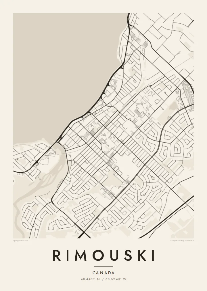
The St. Lawrence opens so wide here that it fills much of the poster, with the city arranged along its shore like a coastal town.
Pousita mape faigofie · Canada
48.4488° N / 68.5240° W
A long shoreline city on the St. Lawrence estuary, where the river is so wide it reads like the sea.




Taone e tasi, lagona e lima
Pau te tapaki o se style ke lavea i luga i te puipui. E tutasi te tau o style takitasi — telotele mo faaki, e aunoa io me fai ki faila HD.
 Pixel tonu · faila lolomi 24 × 36″
Manino ki te lomiga
Tenei se 100% mai te faila lolomi tonu. Poster takitasi — telotele, faaki io me download — e faite i luga i a matou server i te 300 DPI, e oko atu ki 7,200 × 10,800 pixel, ko ala e maofio ei mo maiga vaega foliki i luga i te lolomi 24 × 36″.
I te pakitala


Te mape
Rimouski lies on the south shore of the St. Lawrence in the Bas-Saint-Laurent region of Quebec. Here the estuary is wide enough that the opposite shore is barely visible, and on the map the water takes up a large part of the frame. The city stretches in a long band along the coast, with the Rimouski River entering the estuary in the centre.
Streets run parallel to the shore and climb gently inland in terraces. After a major fire in 1950 destroyed a large part of the town, much of it was rebuilt, and the centre today reflects that period of reconstruction. The city is also home to a university campus known for its marine sciences.
East of the centre, near Pointe-au-Père, the Empress of Ireland sank in 1914 after a collision in the fog, one of the worst maritime disasters in Canadian history. A Rimouski map poster shows the city's close relationship with the river, from the marina to the lighthouse.
The St. Lawrence opens so wide here that it fills much of the poster, with the city arranged along its shore like a coastal town.
The river enters the estuary in the city centre, interrupting the shoreline and creating a natural division in the street pattern.
The historic lighthouse site to the east overlooks the waters where the Empress of Ireland sank in 1914, now remembered at a museum.
Fai ke fakatau ki a koe
Fakaopoopo se aso, se igoa io me se fuaiupu o koe, sui te sitaila, te lasi io me te tuuga.
Te preview fua e maulalo te malamalama kae iai se watermark. Poster telotele mo faila HD e faite i te 300 DPI, e oko atu ki 7,200 × 10,800 px, aunoa mo se watermark.
Kaia a Rimouski
Rimouski is a city of students, sailors and families who have lived by the river for generations. A map of it captures the long shoreline and the way the city faces the water, a good reminder of home or of years at university.
Edit the title, subtitle and coordinates line, in French or in English. Blueprint and Noir suit the estuary's cold waters, and Classic black & white, Paper and Sand are also available.
Otaina te poster Rimouski| Lasi o te lomiga | Manino | Faila |
|---|---|---|
| 30 × 40 cm11.8 × 15.7″ | 3,543 × 4,724 px | PNG · PDF |
| 29.7 × 42 cm (A3)11.7 × 16.5″ | 3,508 × 4,961 px | PNG · PDF |
| 42 × 59.4 cm (A2)16.5 × 23.4″ | 4,961 × 7,016 px | PNG · PDF |
| 45.7 × 61 cm18 × 24″ | 5,400 × 7,200 px | PNG · PDF |
| 50 × 70 cm19.7 × 27.6″ | 5,906 × 8,268 px | PNG · PDF |
| 61 × 91.4 cm24 × 36″ | 7,200 × 10,800 px | PNG · PDF |
Ke fakatusa, a te ata fakataitai fua e 900 px te lautele, mo te fakailoga kae mo lau lavea i luga i te komipiuta. A faila HD e oko ki te 8× te manino i itu katoa kae lomi faka‵lei i te lasi katoa o te pousita.
Filifili se style i te pito i luga o te itulau, kae filifili Poster Telotele — se lasi mo se faaki manafai e manako koe — io me Faila Digital HD. E tasi te sitepu mo te checkout, kae ka fakafou te itulau o tau ota i te taimi e mafai ei te totogi.
E telotele i luga o te pepa vali gali 200 gsm i se tasi mai lasi e ono, mai te 30 × 40 cm ki te 24 × 36″. E kamata te poster telotele mai i te $39, kae aofia ei te uta.
Ioe. Filifili se faaki lakau maoli i te kulokula, tea, oak maoli io me lakau pogisa. E oo mai ki tioata e se malepe kae toka ke tautau. E kamata te poster faaki mai i te $99, kae aofia ei te uta.
E tuku fua ki fenua e 60+. A poloaiga taki tasi e ta ne te tauhaga e latalata mai i a matou tauhaga ta i fenua e 30+, kae e masani o aunoa i aso galue e 3–7. E mafai o salasala te tulaga mo te sukesuke i lalo o Aku poloaiga. I nisi fenua e 2–5 vaiaso, kae i mea e seki tuku atu ei matou, e fakailoa atu e te mea tafaoga i mua o te totogi.
Auina mai se ata i loto i te 14 aso mai te taimi e oko ei kae ka toe telotele fua ne matou io me toe totogi atu tau tupe.
Ioe. I te editor i te itulau tenei, sui te ulutala, te ulutala lalo mo te laina o coordinate ki so se mea e manako koe, kae filifili se style mo se lasi. Oga telotele, faaki mo digital e faigana katoa i tau tusiga tonu.
Mo te $9 ka maua ne koe faila PNG 300 DPI mo PDF fakatoka lolomi i lasi e ono katoa, aunoa mo se watermark, ke lolomi i so se koga. E se mautinoa koe? Download muamua se preview fua e iai te watermark.
Koga pili
