Sundarbans edge
The mangrove forest begins just to the south, its maze of creeks and channels forming one of the most intricate textures any map can show.
Pousita mape faigofie · Bangladesh
22.3101° N / 89.7911° E
A riverside area on the edge of the Sundarbans, where tidal channels and embankments meet the mangrove forest


Taone e tasi, lagona e lima
Pau te tapaki o se style ke lavea i luga i te puipui. E tutasi te tau o style takitasi — telotele mo faaki, e aunoa io me fai ki faila HD.
 Pixel tonu · faila lolomi 24 × 36″
Manino ki te lomiga
Tenei se 100% mai te faila lolomi tonu. Poster takitasi — telotele, faaki io me download — e faite i luga i a matou server i te 300 DPI, e oko atu ki 7,200 × 10,800 pixel, ko ala e maofio ei mo maiga vaega foliki i luga i te lolomi 24 × 36″.
I te pakitala


Te mape
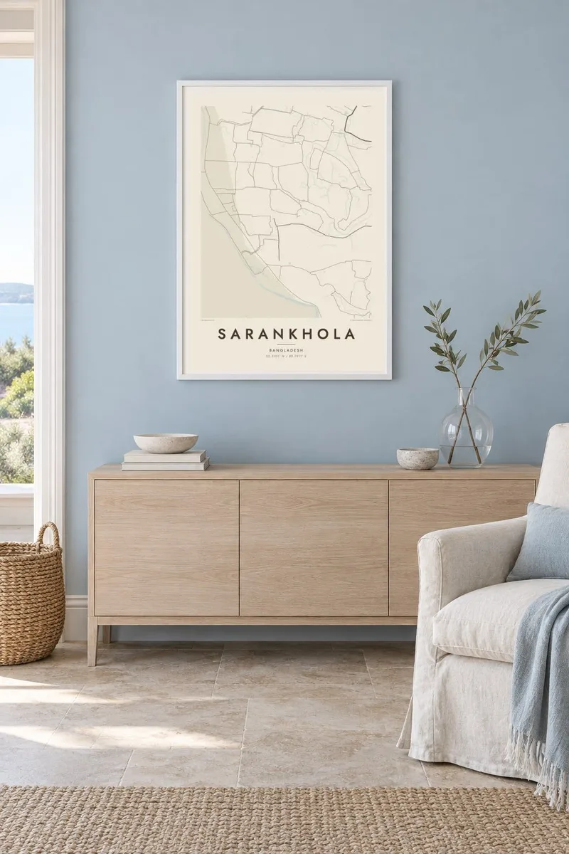
Sarankhola lies in Bagerhat District in southwestern Bangladesh, at the northern edge of the Sundarbans, the largest mangrove forest in the world. The landscape here is shaped almost entirely by water. On the map, rivers and tidal creeks branch across the land in intricate patterns, with villages, fields and roads following the raised embankments that run between them.
The broad Baleshwar River forms a strong boundary on one side, while to the south the settled land gives way to the dense, channel-laced forest. Houses tend to line the embankments in narrow strips, and small markets grow where roads and waterways meet. The area was hit hard by Cyclone Sidr in 2007, and embankments and cyclone shelters remain part of daily life.
A Sarankhola map poster renders this delicate, water-bound geography with unusual clarity. Rivers and creeks become fine, branching lines, the forest edge a softer texture, and the settlements thin, deliberate strokes along the banks. It is a map of a place defined by its relationship with tides and mangroves, and it looks quite unlike any conventional town plan.
The mangrove forest begins just to the south, its maze of creeks and channels forming one of the most intricate textures any map can show.
The wide river running past the area is a major waterway of the southern delta, a broad band that anchors the whole composition.
Homes and roads follow raised embankments between the waterways, producing long, narrow lines of settlement rather than a compact centre or a street grid.
Fai ke fakatau ki a koe
Fakaopoopo se aso, se igoa io me se fuaiupu o koe, sui te sitaila, te lasi io me te tuuga.
Te preview fua e maulalo te malamalama kae iai se watermark. Poster telotele mo faila HD e faite i te 300 DPI, e oko atu ki 7,200 × 10,800 px, aunoa mo se watermark.
Kaia a Sarankhola
People from Sarankhola often carry a deep attachment to the rivers and the forest, especially if they now live in Dhaka, Khulna or overseas. A map of home keeps that landscape present, and it also appeals to anyone who has travelled into the Sundarbans.
Personalise the title, subtitle and coordinates line to name a village, a family or a year. Choose from Classic black & white, Noir, Paper, Blueprint and Sand, then download six print sizes as 300 DPI PNG and print-ready PDF files for $9.
Otaina te poster Sarankhola| Lasi o te lomiga | Manino | Faila |
|---|---|---|
| 30 × 40 cm11.8 × 15.7″ | 3,543 × 4,724 px | PNG · PDF |
| 29.7 × 42 cm (A3)11.7 × 16.5″ | 3,508 × 4,961 px | PNG · PDF |
| 42 × 59.4 cm (A2)16.5 × 23.4″ | 4,961 × 7,016 px | PNG · PDF |
| 45.7 × 61 cm18 × 24″ | 5,400 × 7,200 px | PNG · PDF |
| 50 × 70 cm19.7 × 27.6″ | 5,906 × 8,268 px | PNG · PDF |
| 61 × 91.4 cm24 × 36″ | 7,200 × 10,800 px | PNG · PDF |
Ke fakatusa, a te ata fakataitai fua e 900 px te lautele, mo te fakailoga kae mo lau lavea i luga i te komipiuta. A faila HD e oko ki te 8× te manino i itu katoa kae lomi faka‵lei i te lasi katoa o te pousita.
Filifili se style i te pito i luga o te itulau, kae filifili Poster Telotele — se lasi mo se faaki manafai e manako koe — io me Faila Digital HD. E tasi te sitepu mo te checkout, kae ka fakafou te itulau o tau ota i te taimi e mafai ei te totogi.
E telotele i luga o te pepa vali gali 200 gsm i se tasi mai lasi e ono, mai te 30 × 40 cm ki te 24 × 36″. E kamata te poster telotele mai i te $39, kae aofia ei te uta.
Ioe. Filifili se faaki lakau maoli i te kulokula, tea, oak maoli io me lakau pogisa. E oo mai ki tioata e se malepe kae toka ke tautau. E kamata te poster faaki mai i te $99, kae aofia ei te uta.
E tuku fua ki fenua e 60+. A poloaiga taki tasi e ta ne te tauhaga e latalata mai i a matou tauhaga ta i fenua e 30+, kae e masani o aunoa i aso galue e 3–7. E mafai o salasala te tulaga mo te sukesuke i lalo o Aku poloaiga. I nisi fenua e 2–5 vaiaso, kae i mea e seki tuku atu ei matou, e fakailoa atu e te mea tafaoga i mua o te totogi.
Auina mai se ata i loto i te 14 aso mai te taimi e oko ei kae ka toe telotele fua ne matou io me toe totogi atu tau tupe.
Ioe. I te editor i te itulau tenei, sui te ulutala, te ulutala lalo mo te laina o coordinate ki so se mea e manako koe, kae filifili se style mo se lasi. Oga telotele, faaki mo digital e faigana katoa i tau tusiga tonu.
Mo te $9 ka maua ne koe faila PNG 300 DPI mo PDF fakatoka lolomi i lasi e ono katoa, aunoa mo se watermark, ke lolomi i so se koga. E se mautinoa koe? Download muamua se preview fua e iai te watermark.
