Survey grid roads
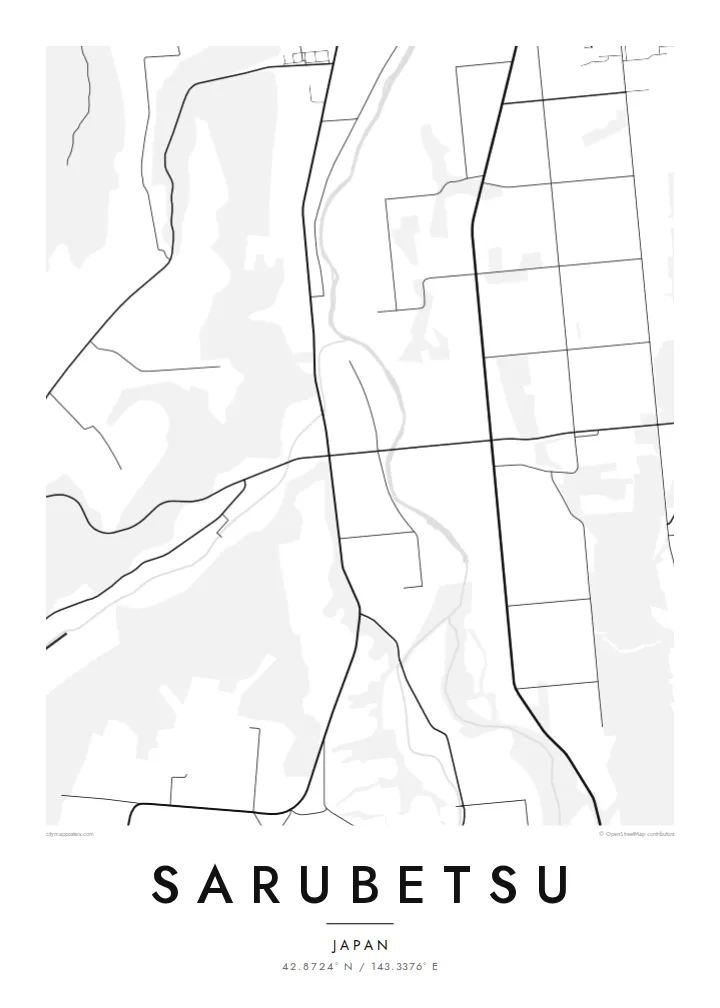
Straight roads cross the plain at regular intervals and divide it into large blocks, giving the map a calm geometric structure that feels closer to the American Midwest than to the rest of Japan.
Pousita mape faigofie · Japan
42.8724° N / 143.3376° E
Farmland on the Tokachi plain of Hokkaido, drawn in long straight roads, windbreak lines and wide rectangular fields.


Taone e tasi, lagona e lima
Pau te tapaki o se style ke lavea i luga i te puipui. E tutasi te tau o style takitasi — telotele mo faaki, e aunoa io me fai ki faila HD.
 Pixel tonu · faila lolomi 24 × 36″
Manino ki te lomiga
Tenei se 100% mai te faila lolomi tonu. Poster takitasi — telotele, faaki io me download — e faite i luga i a matou server i te 300 DPI, e oko atu ki 7,200 × 10,800 pixel, ko ala e maofio ei mo maiga vaega foliki i luga i te lolomi 24 × 36″.
I te pakitala


Te mape
Sarubetsu is on the Tokachi plain in eastern Hokkaido, not far from Obihiro. This is one of Japan's great farming regions, and it looks nothing like the dense, winding towns of Honshu. From above, the land is divided by a broad grid of straight roads, a legacy of the planned settlement of Hokkaido from the late nineteenth century onward.
The fields are large and rectangular, often edged by rows of trees planted as windbreaks against the winds that cross the plain. Houses and farm buildings stand singly or in small groups at intervals along the roads. Where a settlement does gather, its streets usually follow the orientation of the surrounding grid rather than breaking away from it.
Tokachi is known across Japan for beans, potatoes, wheat and dairy, and the rhythm of that farming is written into the map. A Sarubetsu map poster is less about monuments than about space: open land, measured lines and the quiet order of a landscape that was deliberately planned and is still worked every season.
Straight roads cross the plain at regular intervals and divide it into large blocks, giving the map a calm geometric structure that feels closer to the American Midwest than to the rest of Japan.
Rows of trees along the field boundaries form thin lines within the grid, appearing as narrow wooded strips that break up the otherwise open farmland.
Farm buildings are spread singly along the roads rather than grouped in villages, so the map shows a fine, even scatter of small shapes across the plain.
Fai ke fakatau ki a koe
Fakaopoopo se aso, se igoa io me se fuaiupu o koe, sui te sitaila, te lasi io me te tuuga.
Te preview fua e maulalo te malamalama kae iai se watermark. Poster telotele mo faila HD e faite i te 300 DPI, e oko atu ki 7,200 × 10,800 px, aunoa mo se watermark.
Kaia a Sarubetsu
This map suits people who have worked or grown up on the Tokachi plain, and anyone drawn to wide, orderly landscapes. Its sparse lines make a quiet, almost architectural poster that sits well in a minimal interior.
Change the title and subtitle to mark a farm name, a family or a year, and keep the coordinates line as a precise reference. Choose one of five styles and download all six print sizes, from 30×40 cm to 24×36″, as PNG and PDF.
Otaina te poster Sarubetsu| Lasi o te lomiga | Manino | Faila |
|---|---|---|
| 30 × 40 cm11.8 × 15.7″ | 3,543 × 4,724 px | PNG · PDF |
| 29.7 × 42 cm (A3)11.7 × 16.5″ | 3,508 × 4,961 px | PNG · PDF |
| 42 × 59.4 cm (A2)16.5 × 23.4″ | 4,961 × 7,016 px | PNG · PDF |
| 45.7 × 61 cm18 × 24″ | 5,400 × 7,200 px | PNG · PDF |
| 50 × 70 cm19.7 × 27.6″ | 5,906 × 8,268 px | PNG · PDF |
| 61 × 91.4 cm24 × 36″ | 7,200 × 10,800 px | PNG · PDF |
Ke fakatusa, a te ata fakataitai fua e 900 px te lautele, mo te fakailoga kae mo lau lavea i luga i te komipiuta. A faila HD e oko ki te 8× te manino i itu katoa kae lomi faka‵lei i te lasi katoa o te pousita.
Filifili se style i te pito i luga o te itulau, kae filifili Poster Telotele — se lasi mo se faaki manafai e manako koe — io me Faila Digital HD. E tasi te sitepu mo te checkout, kae ka fakafou te itulau o tau ota i te taimi e mafai ei te totogi.
E telotele i luga o te pepa vali gali 200 gsm i se tasi mai lasi e ono, mai te 30 × 40 cm ki te 24 × 36″. E kamata te poster telotele mai i te $39, kae aofia ei te uta.
Ioe. Filifili se faaki lakau maoli i te kulokula, tea, oak maoli io me lakau pogisa. E oo mai ki tioata e se malepe kae toka ke tautau. E kamata te poster faaki mai i te $99, kae aofia ei te uta.
E tuku fua ki fenua e 60+. A poloaiga taki tasi e ta ne te tauhaga e latalata mai i a matou tauhaga ta i fenua e 30+, kae e masani o aunoa i aso galue e 3–7. E mafai o salasala te tulaga mo te sukesuke i lalo o Aku poloaiga. I nisi fenua e 2–5 vaiaso, kae i mea e seki tuku atu ei matou, e fakailoa atu e te mea tafaoga i mua o te totogi.
Auina mai se ata i loto i te 14 aso mai te taimi e oko ei kae ka toe telotele fua ne matou io me toe totogi atu tau tupe.
Ioe. I te editor i te itulau tenei, sui te ulutala, te ulutala lalo mo te laina o coordinate ki so se mea e manako koe, kae filifili se style mo se lasi. Oga telotele, faaki mo digital e faigana katoa i tau tusiga tonu.
Mo te $9 ka maua ne koe faila PNG 300 DPI mo PDF fakatoka lolomi i lasi e ono katoa, aunoa mo se watermark, ke lolomi i so se koga. E se mautinoa koe? Download muamua se preview fua e iai te watermark.
