Railway junction
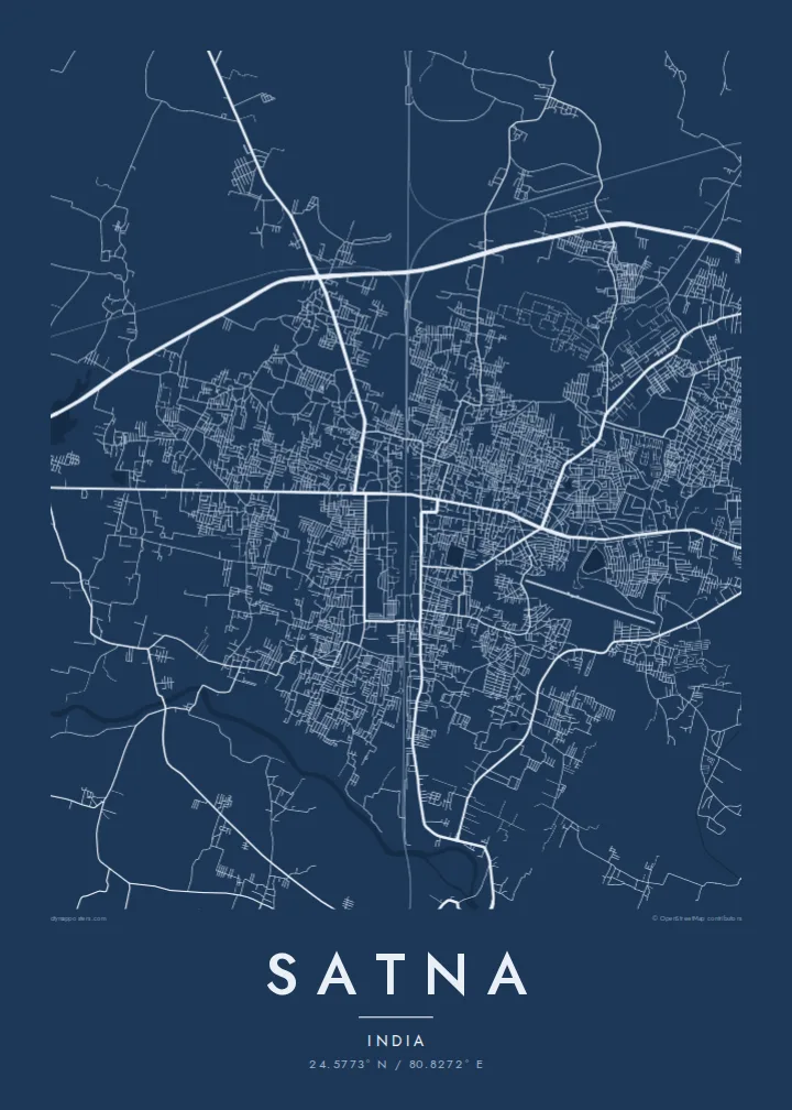
Tracks and yards cut through the town and link it to Jabalpur, Prayagraj and Rewa. On the poster the rail corridor is a dominant line that divides the street pattern into distinct parts.
Pousita mape faigofie · India
24.5773° N / 80.8272° E
A railway town on the Vindhyan plateau, its streets gathered around a junction and edged by quarries and cement works.



Taone e tasi, lagona e lima
Pau te tapaki o se style ke lavea i luga i te puipui. E tutasi te tau o style takitasi — telotele mo faaki, e aunoa io me fai ki faila HD.
 Pixel tonu · faila lolomi 24 × 36″
Manino ki te lomiga
Tenei se 100% mai te faila lolomi tonu. Poster takitasi — telotele, faaki io me download — e faite i luga i a matou server i te 300 DPI, e oko atu ki 7,200 × 10,800 pixel, ko ala e maofio ei mo maiga vaega foliki i luga i te lolomi 24 × 36″.
I te pakitala


Te mape
Satna is a district headquarters in the north-east of Madhya Pradesh, not far from the border with Uttar Pradesh. Its map is organised by the railway: the main line between Jabalpur and Prayagraj passes through, with a branch toward Rewa, and the older bazaar streets cluster close to the station while newer colonies spread across open, gently sloping land beyond.
The town is best known for cement. The limestone of the surrounding Vindhyan rocks has supported several large cement plants, and the industry shapes the edges of the map with works, rail sidings and quarry pits. Satna also serves as a gateway to the pilgrim towns of Chitrakoot and Maihar, both reached by road or rail from here.
A Satna map poster shows a practical, working town rather than a monument city. In line form, the rail corridor becomes a strong axis, the bazaar lanes near the station tighten into a dense knot, and the outskirts open into widely spaced roads, with the small Satna River and its side channels marking the lower ground.
Tracks and yards cut through the town and link it to Jabalpur, Prayagraj and Rewa. On the poster the rail corridor is a dominant line that divides the street pattern into distinct parts.
The small river that gives the town its name winds past the built-up area. Its irregular course provides a soft natural line alongside the straighter roads and rail tracks.
Around the town, plants, rail sidings and quarries leave large geometric shapes in the landscape. They appear on the map as open blocks and spurs at the margins of the built-up area.
Fai ke fakatau ki a koe
Fakaopoopo se aso, se igoa io me se fuaiupu o koe, sui te sitaila, te lasi io me te tuuga.
Te preview fua e maulalo te malamalama kae iai se watermark. Poster telotele mo faila HD e faite i te 300 DPI, e oko atu ki 7,200 × 10,800 px, aunoa mo se watermark.
Kaia a Satna
Satna means a lot to people whose working lives turned on the cement plants or the railway, and to families who passed through on the way to Chitrakoot or Maihar. The map offers a quiet, precise record of a town that is often seen only from a train window.
Put your own words in the title and subtitle, perhaps a colony name or the year you moved there, and adjust the coordinates line. Select one of five styles, check the free watermarked preview, then buy $9 HD files as 300 DPI PNG and print-ready PDF in six sizes.
Otaina te poster Satna| Lasi o te lomiga | Manino | Faila |
|---|---|---|
| 30 × 40 cm11.8 × 15.7″ | 3,543 × 4,724 px | PNG · PDF |
| 29.7 × 42 cm (A3)11.7 × 16.5″ | 3,508 × 4,961 px | PNG · PDF |
| 42 × 59.4 cm (A2)16.5 × 23.4″ | 4,961 × 7,016 px | PNG · PDF |
| 45.7 × 61 cm18 × 24″ | 5,400 × 7,200 px | PNG · PDF |
| 50 × 70 cm19.7 × 27.6″ | 5,906 × 8,268 px | PNG · PDF |
| 61 × 91.4 cm24 × 36″ | 7,200 × 10,800 px | PNG · PDF |
Ke fakatusa, a te ata fakataitai fua e 900 px te lautele, mo te fakailoga kae mo lau lavea i luga i te komipiuta. A faila HD e oko ki te 8× te manino i itu katoa kae lomi faka‵lei i te lasi katoa o te pousita.
Filifili se style i te pito i luga o te itulau, kae filifili Poster Telotele — se lasi mo se faaki manafai e manako koe — io me Faila Digital HD. E tasi te sitepu mo te checkout, kae ka fakafou te itulau o tau ota i te taimi e mafai ei te totogi.
E telotele i luga o te pepa vali gali 200 gsm i se tasi mai lasi e ono, mai te 30 × 40 cm ki te 24 × 36″. E kamata te poster telotele mai i te $39, kae aofia ei te uta.
Ioe. Filifili se faaki lakau maoli i te kulokula, tea, oak maoli io me lakau pogisa. E oo mai ki tioata e se malepe kae toka ke tautau. E kamata te poster faaki mai i te $99, kae aofia ei te uta.
E tuku fua ki fenua e 60+. A poloaiga taki tasi e ta ne te tauhaga e latalata mai i a matou tauhaga ta i fenua e 30+, kae e masani o aunoa i aso galue e 3–7. E mafai o salasala te tulaga mo te sukesuke i lalo o Aku poloaiga. I nisi fenua e 2–5 vaiaso, kae i mea e seki tuku atu ei matou, e fakailoa atu e te mea tafaoga i mua o te totogi.
Auina mai se ata i loto i te 14 aso mai te taimi e oko ei kae ka toe telotele fua ne matou io me toe totogi atu tau tupe.
Ioe. I te editor i te itulau tenei, sui te ulutala, te ulutala lalo mo te laina o coordinate ki so se mea e manako koe, kae filifili se style mo se lasi. Oga telotele, faaki mo digital e faigana katoa i tau tusiga tonu.
Mo te $9 ka maua ne koe faila PNG 300 DPI mo PDF fakatoka lolomi i lasi e ono katoa, aunoa mo se watermark, ke lolomi i so se koga. E se mautinoa koe? Download muamua se preview fua e iai te watermark.
