Genoese fort island
A rocky island topped with a Genoese fort sits just offshore. It shows on the map as a bold, separate shape beside the harbour.
Pousita mape faigofie · Tunisia
36.9544° N / 8.7580° E
A small port town on Tunisia's north coast, with a Genoese fort on a rocky island joined by a causeway


Taone e tasi, lagona e lima
Pau te tapaki o se style ke lavea i luga i te puipui. E tutasi te tau o style takitasi — telotele mo faaki, e aunoa io me fai ki faila HD.
 Pixel tonu · faila lolomi 24 × 36″
Manino ki te lomiga
Tenei se 100% mai te faila lolomi tonu. Poster takitasi — telotele, faaki io me download — e faite i luga i a matou server i te 300 DPI, e oko atu ki 7,200 × 10,800 pixel, ko ala e maofio ei mo maiga vaega foliki i luga i te lolomi 24 × 36″.
I te pakitala


Te mape
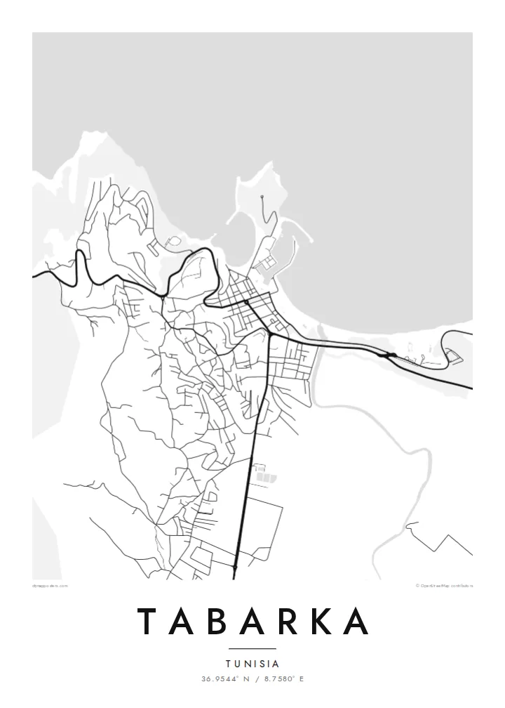
Tabarka lies on the north-western coast of Tunisia, close to the Algerian border. Here the forested Kroumirie hills come down to the Mediterranean. On a map, the town wraps around a small bay and harbour. Just offshore sits a rocky island crowned by a fort built by the Genoese, who held it for coral fishing from the sixteenth century.
The island is joined to the mainland by a narrow causeway. Along the coast west of the harbour stand the Aiguilles, tall sea-worn rock needles that are one of the town's best-known sights. Tabarka is also known for coral diving, for the cork oak forests inland and for the music festivals held here in summer.
A Tabarka map poster is shaped by the coastline: the bay, the causeway, the island and the rocky shore beyond. It is a composition full of distinct shapes. The Sand and Paper styles suit the Mediterranean setting, while Noir sets the white coastline sharply against dark water.
A rocky island topped with a Genoese fort sits just offshore. It shows on the map as a bold, separate shape beside the harbour.
A narrow causeway links the island to the town. It draws a thin, direct line across the water that is easy to pick out.
West of the harbour, tall rock needles known as the Aiguilles line the shore. They mark one of the most recognisable stretches of coast.
Fai ke fakatau ki a koe
Fakaopoopo se aso, se igoa io me se fuaiupu o koe, sui te sitaila, te lasi io me te tuuga.
Te preview fua e maulalo te malamalama kae iai se watermark. Poster telotele mo faila HD e faite i te 300 DPI, e oko atu ki 7,200 × 10,800 px, aunoa mo se watermark.
Kaia a Tabarka
Tabarka is a place people return to: for diving, for festivals, or simply for the quiet of a small coastal town. A map of the bay and fort keeps that setting in view long after the trip is over.
Add your own title and subtitle, for example a year or a name, and keep the coordinates line. Then choose Classic black & white, Noir, Paper, Blueprint or Sand. Sand works especially well with this coast.
Otaina te poster Tabarka| Lasi o te lomiga | Manino | Faila |
|---|---|---|
| 30 × 40 cm11.8 × 15.7″ | 3,543 × 4,724 px | PNG · PDF |
| 29.7 × 42 cm (A3)11.7 × 16.5″ | 3,508 × 4,961 px | PNG · PDF |
| 42 × 59.4 cm (A2)16.5 × 23.4″ | 4,961 × 7,016 px | PNG · PDF |
| 45.7 × 61 cm18 × 24″ | 5,400 × 7,200 px | PNG · PDF |
| 50 × 70 cm19.7 × 27.6″ | 5,906 × 8,268 px | PNG · PDF |
| 61 × 91.4 cm24 × 36″ | 7,200 × 10,800 px | PNG · PDF |
Ke fakatusa, a te ata fakataitai fua e 900 px te lautele, mo te fakailoga kae mo lau lavea i luga i te komipiuta. A faila HD e oko ki te 8× te manino i itu katoa kae lomi faka‵lei i te lasi katoa o te pousita.
Filifili se style i te pito i luga o te itulau, kae filifili Poster Telotele — se lasi mo se faaki manafai e manako koe — io me Faila Digital HD. E tasi te sitepu mo te checkout, kae ka fakafou te itulau o tau ota i te taimi e mafai ei te totogi.
E telotele i luga o te pepa vali gali 200 gsm i se tasi mai lasi e ono, mai te 30 × 40 cm ki te 24 × 36″. E kamata te poster telotele mai i te $39, kae aofia ei te uta.
Ioe. Filifili se faaki lakau maoli i te kulokula, tea, oak maoli io me lakau pogisa. E oo mai ki tioata e se malepe kae toka ke tautau. E kamata te poster faaki mai i te $99, kae aofia ei te uta.
E tuku fua ki fenua e 60+. A poloaiga taki tasi e ta ne te tauhaga e latalata mai i a matou tauhaga ta i fenua e 30+, kae e masani o aunoa i aso galue e 3–7. E mafai o salasala te tulaga mo te sukesuke i lalo o Aku poloaiga. I nisi fenua e 2–5 vaiaso, kae i mea e seki tuku atu ei matou, e fakailoa atu e te mea tafaoga i mua o te totogi.
Auina mai se ata i loto i te 14 aso mai te taimi e oko ei kae ka toe telotele fua ne matou io me toe totogi atu tau tupe.
Ioe. I te editor i te itulau tenei, sui te ulutala, te ulutala lalo mo te laina o coordinate ki so se mea e manako koe, kae filifili se style mo se lasi. Oga telotele, faaki mo digital e faigana katoa i tau tusiga tonu.
Mo te $9 ka maua ne koe faila PNG 300 DPI mo PDF fakatoka lolomi i lasi e ono katoa, aunoa mo se watermark, ke lolomi i so se koga. E se mautinoa koe? Download muamua se preview fua e iai te watermark.
