Markala dam
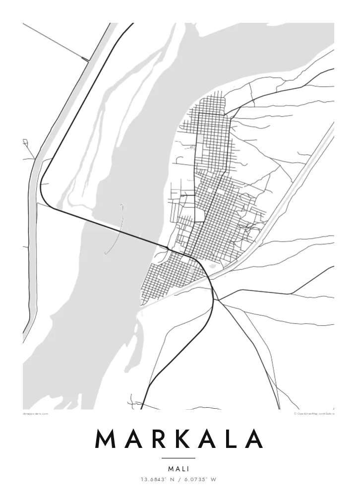
The dam spans the Niger in a long, straight line and carries a road across the river. On the poster it is the single strongest feature.
ቀላል ንድፍ ያለው የካርታ ፖስተር · ማሊ
13.6843° N / 6.0735° W
A river town on the Niger where a long dam crosses the water and canals fan out into irrigated land.


አንድ ከተማ፣ አምስት ስሜቶች
ዘይቤ በመንካት በግድግዳ ላይ ይመልከቱት። ሁሉም ዘይቤዎች ተመሳሳይ ዋጋ አላቸው — የታተመ፣ በፍሬም የተደረገ ወይም እንደ HD ፋይል።
 ትክክለኛ ፒክሰሎች · 24 × 36″ የህትመት ፋይል
ለህትመት ጥርት ያለ
ይህ ከትክክለኛው የህትመት ፋይል 100% የተቆረጠ ክፍል ነው። እያንዳንዱ ፖስተር — የታተመ፣ በፍሬም የተደረገ ወይም የወረደ — በእኛ አገልጋዮች ላይ በ300 DPI፣ እስከ 7,200 × 10,800 ፒክሰሎች ይሠራል፣ ስለዚህ በ24 × 36″ ህትመት ላይ እንኳን ትንንሾቹ መንገዶች ግልጽ ሆነው ይቆያሉ።
በግድግዳ ላይ


ካርታው
Markala sits on the Niger in the Ségou region of Mali, and its map is defined by one structure: the Markala dam. Completed in the 1940s, it raises the river to feed the canals of the Office du Niger, one of the largest irrigation schemes in West Africa. A road runs across the dam, making it also an important river crossing.
The town itself is modest, laid out in blocks of low buildings near the riverbank. From above, the Niger dominates as a broad, pale expanse. Channels branch away from it towards farmland where rice and other crops depend on the water the dam diverts.
A Markala map poster captures a landscape shaped by water engineering. The dam cuts a straight line across the natural curve of the river, the canals draw long strokes into the plain, and the town sits compactly where they meet. It is a spare, graphic map that tells a clear story.
The dam spans the Niger in a long, straight line and carries a road across the river. On the poster it is the single strongest feature.
Canals lead away from the river to the Office du Niger farmlands, forming straight, deliberate lines through otherwise flat and open country.
The river is wide here and fills much of the frame, giving the map a large, calm area of water around the town's small grid.
የራስዎ ያድርጉት
ቀን፣ ስም ወይም የራስዎን ጽሑፍ ያክሉ፤ ስታይልን፣ መጠንን ወይም አቅጣጫን ይቀይሩ።
ነፃው ቅድመ-እይታ ዝቅተኛ ጥራት ያለው እና የውሃ ምልክት ያለበት ነው። ህትመቶች እና HD ፋይሎች በ300 DPI፣ እስከ 7,200 × 10,800 px፣ ያለ ውሃ ምልክት ይሠራሉ።
ለምን Markala
For people from Markala and the Ségou region, the dam and the river are part of daily life. A map of the town keeps that landscape close, and it suits anyone interested in rivers or large water projects.
Personalise the title, subtitle and coordinates line, in French, Bambara or English. Choose from Classic black and white, Noir, Paper, Blueprint and Sand. Blueprint suits the engineered lines of the dam and canals particularly well.
የMarkala ፖስተር ይዘዙ| የህትመት መጠን | ጥራት | ፋይሎች |
|---|---|---|
| 30 × 40 cm (11.8 × 15.7″) | 3,543 × 4,724 px | PNG · PDF |
| 29.7 × 42 cm (A3, 11.7 × 16.5″) | 3,508 × 4,961 px | PNG · PDF |
| 42 × 59.4 cm (A2, 16.5 × 23.4″) | 4,961 × 7,016 px | PNG · PDF |
| 45.7 × 61 cm (18 × 24″) | 5,400 × 7,200 px | PNG · PDF |
| 50 × 70 cm (19.7 × 27.6″) | 5,906 × 8,268 px | PNG · PDF |
| 61 × 91.4 cm (24 × 36″) | 7,200 × 10,800 px | PNG · PDF |
ለማነጻጸር፣ ነፃው ቅድመ እይታ 900 px ስፋት ያለው፣ የውሃ ምልክት ያለበት እና ለስክሪን የታሰበ ነው። HD ፋይሎቹ በእያንዳንዱ አቅጣጫ እስከ 8 እጥፍ ጥራት አላቸው፤ በሙሉ የፖስተር መጠንም በንጽህና ይታተማሉ።
በገጹ የላይኛው ክፍል ላይ ዘይቤ ይምረጡ፣ ከዚያም የታተመ ፖስተር — መጠን እና ካስፈለገ ፍሬም — ወይም ዲጂታል HD ፋይሎችን ይምረጡ። ክፍያው በአንድ ደረጃ ይጠናቀቃል፣ ክፍያው እንደተጠናቀቀ የትዕዛዝ ገጽዎ ወዲያውኑ ይዘምናል።
በስድስት መጠኖች ውስጥ በአንዱ፣ ከ30 × 40 ሴ.ሜ እስከ 24 × 36″ ባለ ከፍተኛ ጥራት 200 gsm ማት ወረቀት ላይ ይታተማል። የታተሙ ፖስተሮች ከ{printFrom} ጀምሮ ናቸው፣ ማጓጓዣን ጨምሮ።
አዎ። ጠንካራ የእንጨት ፍሬም በጥቁር፣ በነጭ፣ በተፈጥሯዊ ኦክ ወይም በጥቁር እንጨት ይምረጡ። የማይሰበር መስታወት ያለው ሲሆን ወዲያውኑ ለመስቀል ዝግጁ ነው። በፍሬም የተደረጉ ፖስተሮች ከ{framedFrom} ጀምሮ ናቸው፣ ማጓጓዣን ጨምሮ።
ማጓጓዣ በዓለም ዙሪያ ነፃ ነው። እያንዳንዱ ፖስተር ከ30+ ሀገራት በሚገኙ የህትመት አጋሮቻችን መካከል ቅርብ በሆነው ይታተምና በተለምዶ በ3–7 የስራ ቀናት ውስጥ ይደርሳል። ሁኔታውን እና ክትትሉን ከ«የእኔ ትዕዛዞች» ስር መከታተል ይችላሉ።
በደረሰ በ14 ቀናት ውስጥ ፎቶ ይላኩልን፣ በነፃ እንደግመዋለን ወይም ገንዘብዎን እንመልሳለን።
አዎ። በዚህ ገጽ ላይ ባለው አርታኢ ውስጥ፣ ርዕሱን፣ ንዑስ ርዕሱን እና የመጋጠሚያ መስመሩን እንደፈለጉት ይቀይሩ፣ ዘይቤ እና መጠን ይምረጡ። የታተሙ፣ በፍሬም የተደረጉ እና ዲጂታል ትዕዛዞች ሁሉም የእርስዎን ንድፍ በትክክል ይጠቀማሉ።
በ$9 በ300 DPI PNG እና ለህትመት ዝግጁ የሆኑ PDF ፋይሎችን በሁሉም ስድስት መጠኖች፣ ያለ ውሃ ምልክት፣ በየትኛውም ቦታ ለማተም ያገኛሉ። እርግጠኛ ካልሆኑ? መጀመሪያ ነፃ የውሃ ምልክት ያለበት ቅድመ-እይታ ያውርዱ።
