Rail corridor
The railway and the parallel main road run through Bibai from north to south. They form the axis along which the whole city is arranged.
Simpol poster blong map · Japan
43.3247° N / 141.8586° E
A former coal town on the Ishikari Plain, stretched along the railway between rice paddies and the wooded hills to the east.


Wan taon, faef filing
Klikim wan style blong luk hem antap long wol. Evri style i sem prais nomo — sapos yu prinim, putum insaed frem, o daonlodem olsem HD file.
 Trufala pixel · 24 × 36″ prin file
Klia blong prent
Hemia i wan 100% haf blong trufala prin file. Evri poster — sapos prinim, putum insaed frem, o daonlodem — mifala i wokem long server blong mifala long 300 DPI, kasem 7,200 × 10,800 pixel, mekem se nomata ol smol rod tu oli klia gud long wan 24 × 36″ prin.
Long wol


Map
Bibai lies in central Hokkaido, on the Ishikari Plain between Sapporo and Asahikawa. For much of the twentieth century it was a coal-mining city. The mines have since closed, and the city now depends more on farming, with rice fields covering much of the flat land to the west.
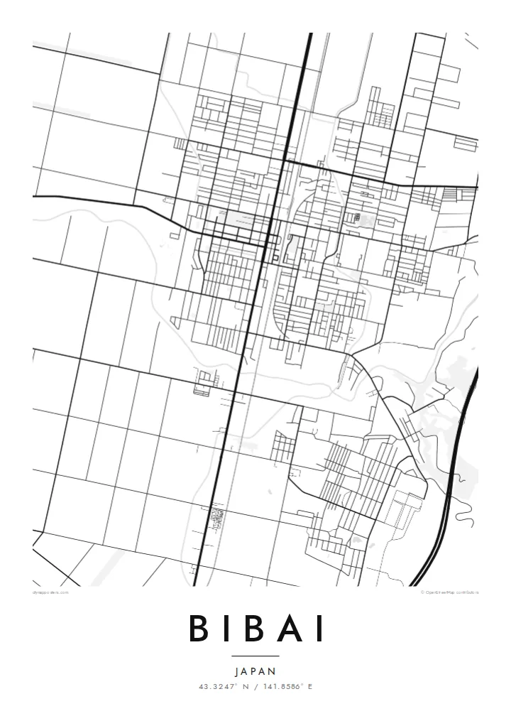
On a map Bibai forms a long, narrow band along the railway line and the main road, which run north to south through the centre. To the west the paddies make a fine, regular grid of rectangles. To the east the ground rises into forested hills, where the old mining districts once stood.
A Bibai map poster shows that division clearly: an ordered agricultural plain on one side, broken hill country on the other, and the town strung along the rail corridor in between. The city is also known for Arte Piazza Bibai, a sculpture park by Kan Yasuda set in a former school.
The railway and the parallel main road run through Bibai from north to south. They form the axis along which the whole city is arranged.
West of the centre, rice fields divide the plain into small, even rectangles, which gives the lower half of the map a delicate, textile-like pattern.
The land climbs toward wooded hills to the east. Scattered roads there trace the valleys where the mining settlements once were.
Mekem i blong yu
Putum wan dei, wan nem o wan laen blong yu, jenisim stael, saes o saed.
Fri preview i lo-resolusen mo i gat watermak. Prin mo HD file oli wok long 300 DPI, kasem 7,200 × 10,800 px, i no gat watermak.
From wanem Bibai
Bibai means something to families shaped by its mining years, and to anyone who has travelled the line between Sapporo and Asahikawa. The map shows how the town grew around the railway and how the plain around it has been farmed.
The title, subtitle and coordinates line can be personalised, and the map comes in Classic black & white, Noir, Paper, Blueprint or Sand. The HD files cost $9 with no watermark, or you can order a matte print with an optional wooden frame.
Odarem poster blong Bibai| Saes blong prent | Rezolusen | Ol fael |
|---|---|---|
| 30 × 40 cm11.8 × 15.7″ | 3,543 × 4,724 px | PNG · PDF |
| 29.7 × 42 cm (A3)11.7 × 16.5″ | 3,508 × 4,961 px | PNG · PDF |
| 42 × 59.4 cm (A2)16.5 × 23.4″ | 4,961 × 7,016 px | PNG · PDF |
| 45.7 × 61 cm18 × 24″ | 5,400 × 7,200 px | PNG · PDF |
| 50 × 70 cm19.7 × 27.6″ | 5,906 × 8,268 px | PNG · PDF |
| 61 × 91.4 cm24 × 36″ | 7,200 × 10,800 px | PNG · PDF |
Blong yu save komperem, fri priviu i 900 px long waed, i gat wotamak mo i blong skrin nomo. Ol HD fael oli gat kasem 8× moa rezolusen long evri saed mo oli prent klia long ful saes blong poster.
Jusum wan style antap long pej, biaen jusum Prinim Poster — wan saes mo, sapos yu wantem, wan frem — o Digital HD Files. Pemen i wan step nomo, mo pej blong oda blong yu i apdet stret taem pemen i pas.
Mifala i prinim long gudfala 200 gsm matte pepa, long wan long 6 saes, statem long 30 × 40 cm kasem 24 × 36″. Prin poster i statem long $39, sipin i insaed finis.
Yes. Jusum wan strong wud frem long kala blak, waet, natural oak, o tudak wud. I gat glas we i no save brok isi, mo i rere blong hangem stret. Poster wetem frem i statem long $99, sipin i insaed finis.
Shipping i fri i go long 60+ kantri. Evri poster i kam from wan long ol prin pATna blong mifala we i stap kolosap moa long 30+ kantri, mo i save kasem yu long 3–7 wokin dei. Yu save lukluk stetus mo tracking long My Orders. Sam kantri i tekem 2–5 wik, mo long ol ples we mifala i no sendem yet, saet i talem yu bifo yu pem.
Sendem wan foto long mifala insaed 14 dei afta i kasem yu, mo mifala bae i prinim wan niufala fri o givim bak mane blong yu.
Yes. Long editor long pej ya, jenisim taetol, sabtaetol, mo laen blong koordinet i go long wanem yu wantem, mo jusum wan style mo saes. Prin, frem, mo digital oda oli yusum stret design blong yu.
Long $9 yu kasem 300 DPI PNG mo PDF file we i rere blong prinim, long evri 6 saes, i no gat watermak, mo yu save prinim long enisave ples. Yu no sua yet? Daonlodem wan fri preview wetem watermak fastaem.
Klosap
