Ria coastline
Drowned valleys form a shoreline of fingers and bays, one of the most intricate coastal outlines a map can show.
Simpol poster blong map · Japan
32.9500° N / 131.9000° E
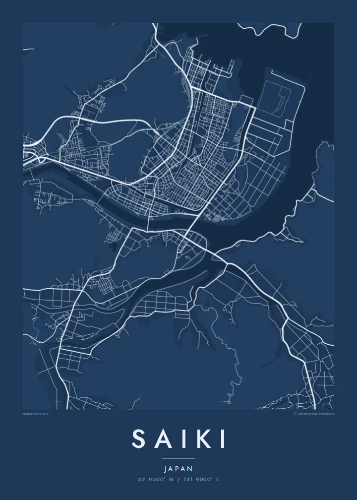
A deeply indented ria coast of inlets, peninsulas and islands, with a castle hill above a river-mouth town.



Wan taon, faef filing
Klikim wan style blong luk hem antap long wol. Evri style i sem prais nomo — sapos yu prinim, putum insaed frem, o daonlodem olsem HD file.
 Trufala pixel · 24 × 36″ prin file
Klia blong prent
Hemia i wan 100% haf blong trufala prin file. Evri poster — sapos prinim, putum insaed frem, o daonlodem — mifala i wokem long server blong mifala long 300 DPI, kasem 7,200 × 10,800 pixel, mekem se nomata ol smol rod tu oli klia gud long wan 24 × 36″ prin.
Long wol


Map
Saiki occupies the southeastern corner of Oita Prefecture, where the Kyushu coast breaks up into a ria shoreline of drowned valleys. On a map the coast is anything but straight: narrow inlets reach far inland, long peninsulas point out toward the Bungo Channel and small islands sit offshore.
The city centre lies on low ground near the mouth of the Banjo River. Above it rises Shiroyama, a wooded hill that once held Saiki Castle; today its stone walls remain, reached by paths through the trees. The streets of the old castle town spread across the flat land at its foot.
Following municipal mergers, Saiki became one of the largest municipalities in Kyushu by area, covering mountain valleys as well as the coast. Fishing villages sit at the heads of many inlets, and the city is well known for its seafood. A Saiki map poster shows that coastline in all its detail, with a small castle town in the middle.
Drowned valleys form a shoreline of fingers and bays, one of the most intricate coastal outlines a map can show.
Shiroyama rises directly behind the town centre, a rounded patch of green with the former castle town's streets gathered below.
The river widens as it reaches the sea near the centre, dividing the low ground and linking the town to the harbour.
Mekem i blong yu
Putum wan dei, wan nem o wan laen blong yu, jenisim stael, saes o saed.
Fri preview i lo-resolusen mo i gat watermak. Prin mo HD file oli wok long 300 DPI, kasem 7,200 × 10,800 px, i no gat watermak.
From wanem Saiki
Anyone who knows the Bungo coast, whether from fishing, family or travel, will recognise this shoreline right away. It is one of those places where the map itself looks like a drawing, with every inlet and island visible.
Personalise the title and subtitle with a name, a date or a stretch of coast, and adjust the coordinates line. Choose Classic black & white, Noir, Paper, Blueprint or Sand. Noir sets off the edge between land and sea especially well.
Odarem poster blong Saiki| Saes blong prent | Rezolusen | Ol fael |
|---|---|---|
| 30 × 40 cm (11.8 × 15.7″) | 3,543 × 4,724 px | PNG · PDF |
| 29.7 × 42 cm (A3, 11.7 × 16.5″) | 3,508 × 4,961 px | PNG · PDF |
| 42 × 59.4 cm (A2, 16.5 × 23.4″) | 4,961 × 7,016 px | PNG · PDF |
| 45.7 × 61 cm (18 × 24″) | 5,400 × 7,200 px | PNG · PDF |
| 50 × 70 cm (19.7 × 27.6″) | 5,906 × 8,268 px | PNG · PDF |
| 61 × 91.4 cm (24 × 36″) | 7,200 × 10,800 px | PNG · PDF |
Blong yu save komperem, fri priviu i 900 px long waed, i gat wotamak mo i blong skrin nomo. Ol HD fael oli gat kasem 8× moa rezolusen long evri saed mo oli prent klia long ful saes blong poster.
Jusum wan style antap long pej, biaen jusum Prinim Poster — wan saes mo, sapos yu wantem, wan frem — o Digital HD Files. Pemen i wan step nomo, mo pej blong oda blong yu i apdet stret taem pemen i pas.
Mifala i prinim long gudfala 200 gsm matte pepa, long wan long 6 saes, statem long 30 × 40 cm kasem 24 × 36″. Prin poster i statem long $39, sipin i insaed finis.
Yes. Jusum wan strong wud frem long kala blak, waet, natural oak, o tudak wud. I gat glas we i no save brok isi, mo i rere blong hangem stret. Poster wetem frem i statem long $99, sipin i insaed finis.
Delivri blong poster i fri long olgeta ples long wol. Wan wan poster i prin long wan long ol prin patna blong mifala we i kolosap moa long yu, long moa long 30 kantri, mo bambae i kasem yu long 3–7 wokdei. Yu save lukluk stetes mo trakin long My Orders. Sam kantri i tekem 2–5 wik, mo long ol ples we mifala i no save sendem yet, saet i talem yu bifo yu pem.
Sendem wan foto long mifala insaed 14 dei afta i kasem yu, mo mifala bae i prinim wan niufala fri o givim bak mane blong yu.
Yes. Long editor long pej ya, jenisim taetol, sabtaetol, mo laen blong koordinet i go long wanem yu wantem, mo jusum wan style mo saes. Prin, frem, mo digital oda oli yusum stret design blong yu.
Long $9 yu kasem 300 DPI PNG mo PDF file we i rere blong prinim, long evri 6 saes, i no gat watermak, mo yu save prinim long enisave ples. Yu no sua yet? Daonlodem wan fri preview wetem watermak fastaem.
Klosap
