Thames meanders
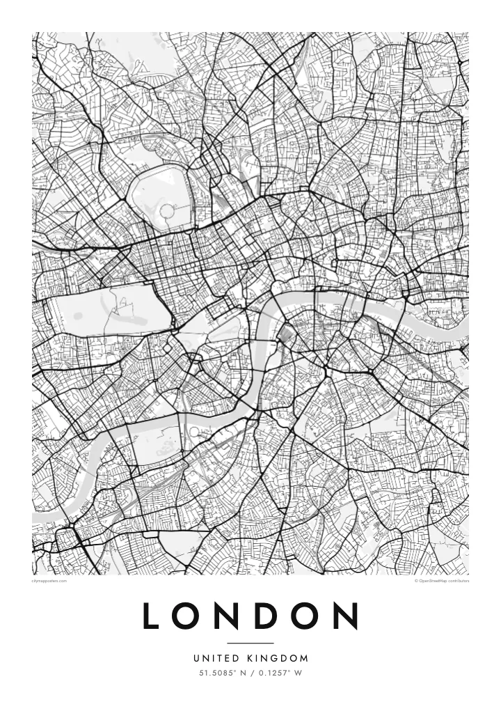
Between Westminster and Greenwich the river swings through a run of sharp bends, including the horseshoe loop around the Isle of Dogs, one of the most recognisable shapes on any city map.
Pòster de mapa minimalista · Regne Unit
51.5085° N / 0.1257° W
No grid and no plan, just a winding river and centuries of villages that grew together into one enormous city.


Una ciutat, cinc ambients
Toca un estil per veure com queda a la paret. Tots els estils tenen el mateix preu, ja sigui imprès, emmarcat o en fitxers HD.
 Píxels reals · fitxer d'impressió de 24 × 36″
Nitidesa d'impressió
Aquesta és una retallada al 100% del fitxer d'impressió real. Cada pòster —imprès, emmarcat o descarregat— es genera als nostres servidors a 300 DPI, fins a 7,200 × 10,800 píxels, de manera que fins i tot els carrers més petits es vegin nítids en una impressió de 24 × 36″.
A la paret


El mapa
London has never had a master plan, and its street map shows it. There is no grid and no dominant axis, only a web of roads that once linked separate villages such as Hampstead, Chelsea and Islington before the city absorbed them. Street names still hint at those origins, and the map reads less like a design than a record of slow accumulation.
The Thames gives it shape. The river snakes from west to east in a series of tight loops, the deepest wrapping around the Isle of Dogs, where Canary Wharf now stands. Upstream sits the City of London, the Square Mile where the Romans founded Londinium, still a separate jurisdiction with its own dense knot of lanes around St Paul's.
Green space breaks up the pattern more than in most capitals. Hyde Park and Kensington Gardens form one broad block in the west, Regent's Park adds its neat Inner Circle to the north, and Hampstead Heath spreads wild and irregular beyond. On a London map poster these parks read as open pauses in an otherwise restless texture of streets.
Between Westminster and Greenwich the river swings through a run of sharp bends, including the horseshoe loop around the Isle of Dogs, one of the most recognisable shapes on any city map.
The City of London, where the Roman settlement began, still follows much of its medieval street pattern of narrow lanes and courts, rebuilt on the old lines after the Great Fire of 1666.
Opened in the early nineteenth century, the canal curves across north London from Little Venice to Limehouse, passing Camden and the edge of Regent's Park as a thin, continuous line of water.
Fes-lo teu
Afegeix una data, un nom o una frase pròpia, i canvia l'estil, la mida o l'orientació.
La previsualització gratuïta és de baixa resolució i porta marca d'aigua. Les impressions i els fitxers HD es generen a 300 DPI, fins a 7,200 × 10,800 px, sense marca d'aigua.
Per què London
London is a city people pass through as often as they settle in, which makes its map a natural keepsake. It can mark a first job, a flatshare in Hackney, years of commuting on the Underground, or a single trip that stayed with you long after the flight home.
Personalise the poster with a title and a date of your choosing, then settle on one of five styles: Classic black & white, Noir, Paper, Blueprint or Sand. Blueprint suits the engineering of the bridges, while Paper and Sand soften the maze of streets for a quieter room.
Demana el pòster de London| Mida d'impressió | Resolució | Fitxers |
|---|---|---|
| 30 × 40 cm11.8 × 15.7″ | 3,543 × 4,724 px | PNG · PDF |
| 29.7 × 42 cm (A3)11.7 × 16.5″ | 3,508 × 4,961 px | PNG · PDF |
| 42 × 59.4 cm (A2)16.5 × 23.4″ | 4,961 × 7,016 px | PNG · PDF |
| 45.7 × 61 cm18 × 24″ | 5,400 × 7,200 px | PNG · PDF |
| 50 × 70 cm19.7 × 27.6″ | 5,906 × 8,268 px | PNG · PDF |
| 61 × 91.4 cm24 × 36″ | 7,200 × 10,800 px | PNG · PDF |
Per comparar, la previsualització gratuïta fa 900 px d'amplada, porta marca d'aigua i està pensada per a pantalles. Els fitxers HD tenen fins a 8 vegades més resolució en cada direcció i s'imprimeixen perfectament a mida de pòster completa.
Tria un estil a la part superior de la pàgina i, després, selecciona Pòster imprès —una mida i, si vols, un marc— o Fitxers digitals HD. El pagament es fa en un sol pas i la pàgina de la teva comanda s'actualitza tan bon punt es confirma el pagament.
S'imprimeix en paper mat premium de 200 g/m² en una de sis mides, des de 30 × 40 cm fins a 24 × 36″. Els pòsters impresos comencen a $39, amb l'enviament inclòs.
Sí. Tria un marc de fusta massissa en negre, blanc, roure natural o fusta fosca. Inclou un vidre irrompible i està llest per penjar. Els pòsters emmarcats comencen a $99, amb l'enviament inclòs.
L'enviament és gratuït a més de 60 països. Cada pòster l'imprimeix el soci d'impressió més proper dels nostres, en més de 30 països, i normalment arriba en 3–7 dies feiners. Pots seguir l'estat i el seguiment a Les meves comandes. Alguns països triguen entre 2 i 5 setmanes, i si encara no enviem al teu, el web t'ho indica abans de pagar.
Envia'ns una foto dins dels 14 dies posteriors a la recepció i te'l tornarem a imprimir gratuïtament o et retornarem els diners.
Sí. A l'editor d'aquesta pàgina pots canviar el títol, el subtítol i la línia de coordenades pel que vulguis, i triar un estil i una mida. Les comandes impreses, emmarcades i digitals fan servir exactament el teu disseny.
Per $9 obtens fitxers PNG a 300 DPI i PDF llestos per imprimir en les sis mides, sense marca d'aigua, per imprimir on vulguis. Encara no ho tens clar? Descarrega abans una previsualització gratuïta amb marca d'aigua.
