Hagåtña waist
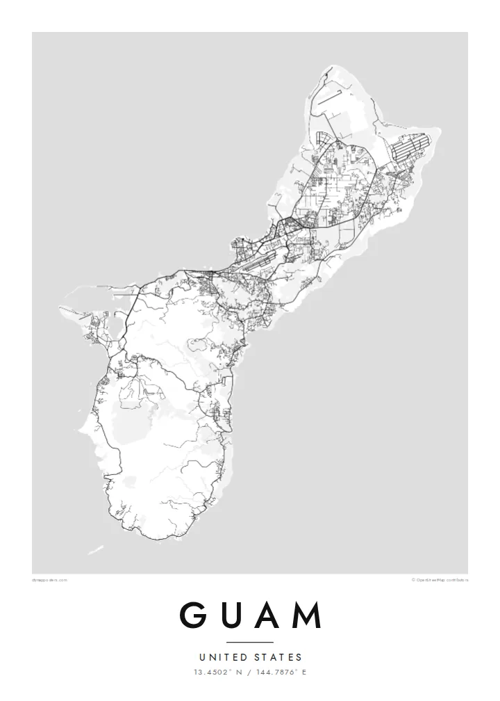
The capital sits where the island narrows, its compact streets pressed between the bay and a limestone ridge. It marks the natural midpoint of the composition and holds the clearest urban texture on the map.
极简地图海报 · 美国
13.4502° N / 144.7876° E
A long, pinched island with a flat limestone north, volcanic southern hills and a harbour carved into its western shore.


一座城市,五种氛围
点击风格,即可预览效果。所有风格价格相同——无论印刷、装框还是 HD 文件。
 实际像素 · 24 × 36″ 印刷文件
印刷级清晰
这是真实印刷文件的 100% 局部截图。每张海报——无论印刷、装框还是下载——都在我们的服务器上以 300 DPI、最高 7,200 × 10,800 像素渲染,即使 24 × 36″ 印刷尺寸下最细的线条也清晰锐利。
上墙效果


关于地图
Guam is the largest and southernmost of the Mariana Islands, a United States territory in the western Pacific. From above it reads as a narrow island about fifty kilometres long, drawn in at the middle where the capital, Hagåtña, sits on the western coast. North of that waist lies a raised limestone plateau with long straight roads and large cleared areas. To the south the land folds into ridges and river valleys.
On a Guam map poster the western shoreline carries most of the detail. Marine Corps Drive traces the coast past Tumon Bay, where hotels line a curved sandy beach, and continues south to Apra Harbor, a deep port sheltered by a breakwater and the Orote Peninsula. The eastern side faces the open ocean and is quieter on paper, with scattered villages and fewer roads between the cliffs and the reef.
Chamorro people settled the island thousands of years before European contact, and village names across the map still reflect that heritage. Not far offshore lies the Mariana Trench, whose Challenger Deep is the deepest known point of the ocean floor, though a poster shows only the reef edge and the coast. What remains is a clear portrait of a small island shaped by both volcanic rock and coral.
The capital sits where the island narrows, its compact streets pressed between the bay and a limestone ridge. It marks the natural midpoint of the composition and holds the clearest urban texture on the map.
A wide, sheltered anchorage on the west coast, framed by the Orote Peninsula and a long breakwater. Its hard-edged piers and basins give the southern half of the poster a strong graphic anchor.
Above the waist, the land becomes a flat limestone table crossed by long straight roads and the broad rectangles of airfields, a far more geometric pattern than the winding valleys of the south.
专属定制
添加日期、名字或一句你自己的话,还可切换风格、尺寸或方向。
免费预览图为低分辨率且带水印。印刷版和 HD 文件以 300 DPI、最高 7,200 × 10,800 px 渲染,无水印。
为什么选 Guam
A Guam poster suits people who were stationed on the island, grew up in one of its villages or spent time along Tumon Bay. The outline is compact enough to show whole, so the print works as a complete portrait of the island rather than a cropped fragment of it.
You can change the title, add a subtitle such as a family name or a date, and edit the coordinates line. Choose from five styles, Classic black & white, Noir, Paper, Blueprint or Sand, then take the $9 HD files in six sizes or order a matte print, framed if you prefer.
订购 Guam 海报| 印刷尺寸 | 分辨率 | 文件 |
|---|---|---|
| 30 × 40 cm (11.8 × 15.7″) | 3,543 × 4,724 px | PNG · PDF |
| 29.7 × 42 cm (A3, 11.7 × 16.5″) | 3,508 × 4,961 px | PNG · PDF |
| 42 × 59.4 cm (A2, 16.5 × 23.4″) | 4,961 × 7,016 px | PNG · PDF |
| 45.7 × 61 cm (18 × 24″) | 5,400 × 7,200 px | PNG · PDF |
| 50 × 70 cm (19.7 × 27.6″) | 5,906 × 8,268 px | PNG · PDF |
| 61 × 91.4 cm (24 × 36″) | 7,200 × 10,800 px | PNG · PDF |
作为对比,免费预览图宽 900 px,带水印,仅适合屏幕浏览。HD 文件在每个方向上的分辨率最高可达其 8 倍,印成全尺寸海报依然清晰。
在页面顶部选择一款风格,然后选择「印刷海报」——选定尺寸,如需要还可加装相框——或选择「数字 HD 文件」。结账只需一步,付款完成后订单页面会立即更新。
采用优质 200 gsm 磨砂纸印刷,提供六种尺寸,从 30 × 40 cm 到 24 × 36″。印刷海报起价 $39,包邮。
可以。可选实木相框,颜色有黑色、白色、原木橡木色或深木色。配防碎玻璃,到手即可挂墙。装框海报起价 $99,包邮。
全球包邮。每张海报由我们在 30 多个国家的合作印刷厂中离你最近的一家印制,通常 3–7 个工作日送达。你可以在“我的订单”中查看订单状态和物流跟踪。少数国家需要 2–5 周;暂不支持配送的国家,网站会在你付款前提示。
请在收货后 14 天内发给我们照片,我们会免费重印或全额退款。
可以。在本页的编辑器中,可以随意修改标题、副标题和坐标行,并选择风格和尺寸。印刷、装框和数字版订单都会完全按照你的设计制作。
只需 $9,即可获得全部六种尺寸的 300 DPI PNG 和可直接印刷的 PDF 文件,无水印,随处可印。还不确定?可以先下载免费的带水印预览图。
