Lake-strewn land
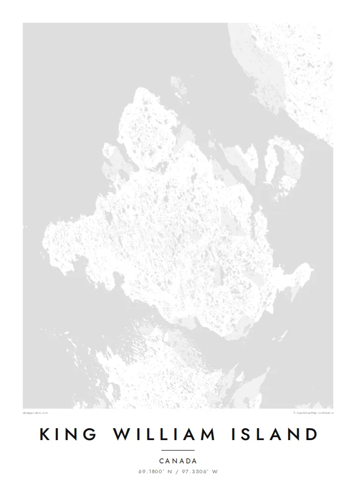
Thousands of small lakes cover the flat interior. They give the map a dense, dotted texture unlike most island outlines.
ސާދާ މެޕް ޕޯސްޓަރު · Canada
69.1800° N / 97.3506° W
A flat Arctic island scattered with lakes, in the channels where the Franklin expedition was lost


އެއް ސިޓީ، ފަސް މޫޑް
ސްޓައިލެއް ޓެޕްކޮށްލައިގެން ފާރުމަތީގައި ބަލާލާ. ހުރިހާ ސްޓައިލެއްގެ އަގުވެސް އެއްވަރެއް — ޕްރިންޓްކޮށްފައި، ފްރޭމްކޮށްފައި ނުވަތަ HD ފައިލްގެ ގޮތުގައި.
 ހަގީގީ ޕިކްސެލް · 24 × 36″ ޕްރިންޓް ފައިލް
ޕްރިންޓަށް ސާފު
މިއީ ހަގީގީ ޕްރިންޓް ފައިލްގެ 100% ކްރޮޕެއް. ކޮންމެ ޕޯސްޓަރެއް — ޕްރިންޓްކޮށްފައި، ފްރޭމްކޮށްފައި ނުވަތަ ޑައުންލޯޑްކޮށްފައި — ތައްޔާރުކުރަނީ އަހަރެމެންގެ ސަރވަރތަކުގައި 300 DPI ގައި، 7,200 × 10,800 ޕިކްސެލާ ހަމައަށް، ވީމާ 24 × 36″ ޕްރިންޓެއްގައިވެސް އެންމެ ކުދި މަގުތައްވެސް ސާފުކޮށް ފެންނާނެ.
ފާރުގައި


މެޕް
King William Island lies in the Kitikmeot Region of Nunavut, in the Canadian Arctic. From above it is a broad, low island. The terrain is almost level, and the landscape is dotted with countless lakes and ponds left by glaciation, so the map looks finely speckled with water.
The only community is Gjoa Haven, on the southeastern coast. It takes its name from the Gjøa, the ship in which Roald Amundsen spent two winters in the harbour in the early 1900s while searching for the Northwest Passage. Inuit taught him skills that helped his expedition succeed.
The waters around the island are where Sir John Franklin's 1840s expedition was lost. The wrecks of HMS Erebus and HMS Terror were found nearby in 2014 and 2016. A King William Island map poster sets this history against a quiet pattern of lakes and shoreline.
Thousands of small lakes cover the flat interior. They give the map a dense, dotted texture unlike most island outlines.
The single settlement sits beside a sheltered harbour on the southeast coast, a small cluster of streets on an otherwise open island.
Narrow channels separate the island from the mainland and neighbouring islands. These are the passages at the heart of the Northwest Passage story.
ތިބާގެ ކޮށްލާ
ތާރީޚެއް، ނަމެއް ނުވަތަ ތިބާގެ އަމިއްލަ ލައިނެއް އިތުރުކުރޭ، ސްޓައިލް، ސައިޒު ނުވަތަ ދިމާ ބަދަލުކުރޭ.
ހިލޭ ޕްރިވިއު ހުންނަނީ ދަށް ރިޒޮލިއުޝަނުގައި، ވޯޓަރމާކާއެކު. ޕްރިންޓް އަދި HD ފައިލްތައް ތައްޔާރުކުރަނީ 300 DPI ގައި، 7,200 × 10,800 px އަށް ހަމައަށް، ވޯޓަރމާކެއް ނެތި.
King William Island ކީއްވެ
For people from Gjoa Haven, and for anyone who has followed the Franklin search or the Northwest Passage, this map carries real meaning. Its lake pattern is also striking as pure design.
Add your own title, subtitle and coordinates line, such as a family name, a year or a place. Choose Classic black & white, Noir, Paper, Blueprint or Sand.
King William Island ޕޯސްޓަރު އޯޑަރުކުރޭ| ޕްރިންޓް ސައިޒު | ރިޒޮލިއުޝަން | ފައިލުތައް |
|---|---|---|
| 30 × 40 cm11.8 × 15.7″ | 3,543 × 4,724 px | PNG · PDF |
| 29.7 × 42 cm (A3)11.7 × 16.5″ | 3,508 × 4,961 px | PNG · PDF |
| 42 × 59.4 cm (A2)16.5 × 23.4″ | 4,961 × 7,016 px | PNG · PDF |
| 45.7 × 61 cm18 × 24″ | 5,400 × 7,200 px | PNG · PDF |
| 50 × 70 cm19.7 × 27.6″ | 5,906 × 8,268 px | PNG · PDF |
| 61 × 91.4 cm24 × 36″ | 7,200 × 10,800 px | PNG · PDF |
އަޅާކިޔާލުމަށް، ހިލޭ ޕްރިވިއުގެ ފުޅާމިނަކީ 900 px، ވޯޓަރމާކާއެކު، ސްކްރީނަށް ހަދާފައިވާ އެއްޗެއް. HD ފައިލުތަކުގައި ކޮންމެ ފަރާތަކަށް 8 ގުނަ އާ ހަމައަށް ރިޒޮލިއުޝަން ހުރެ، ފުރިހަމަ ޕޯސްޓަރު ސައިޒުގައި ސާފުކޮށް ޕްރިންޓްވޭ.
ޞަފްޙާގެ މަތިން ސްޓައިލެއް ހޮވާ، ދެން Printed Poster ހޮވާ — ސައިޒަކާއި، ބޭނުންނަމަ ފްރޭމެއް — ނުވަތަ Digital HD Files ހޮވާ. ޗެކްއައުޓް ނިމެނީ އެންމެ ފިޔަވަޅަކުން، އަދި ފައިސާ ދެއްކުމާއެކު ތިޔަބޭފުޅާގެ އޯޑަރު ޞަފްޙާ އަޕްޑޭޓްވާނެ.
މިއީ ޕްރިމިއަމް 200 gsm މެޓް ކަރުދާހުގައި، 30 × 40 cm އިން 24 × 36″ އަށް ހުންނަ ހަ ސައިޒުގެ ތެރެއިން އެއް ސައިޒެއްގައި ޕްރިންޓްކޮށްފައިވާ ޕޯސްޓަރެއް. ޕްރިންޓްކޮށްފައިވާ ޕޯސްޓަރުތައް ފެށެނީ $39 އިން، ޝިޕިންގ ހިމަނައިގެން.
އާނ. ކަޅު، ހުދު، ނެޗުރަލް އޯކް ނުވަތަ ޑާކް ވުޑްގެ ސޮލިޑް ވުޑް ފްރޭމެއް ހޮވާ. މީގައި ހުންނަނީ ނުތެޅޭ ބިއްލޫރި، އަދި ހަރުކުރަން ފުރިހަމައަށް ތައްޔާރު. ފްރޭމްކޮށްފައިވާ ޕޯސްޓަރުތައް ފެށެނީ $99 އިން، ޝިޕިންގ ހިމަނައިގެން.
60+ ޤައުމަކަށް ޝިޕިންގ ހިލޭ. ކޮންމެ ޕޯސްޓަރަކީވެސް 30+ ޤައުމެއްގައި ހުރި އަޅުގަނޑުމެންގެ ޕްރިންޓް ޕާޓްނަރުންގެ ތެރެއިން ކައިރިން ހުރި ޕާޓްނަރަކު ޕްރިންޓްކުރާ ކަމަށާއި، އާންމުކޮށް 3–7 ވަޒީފާ ދުވަހުގެ ތެރޭގައި ލިބެއެވެ. ސްޓޭޓަސް އަދި ޓްރެކިންގ ބެލޭނީ "އަހަރެންގެ އޯޑަރުތައް" ގައެވެ. ބައެއް ޤައުމުތަކަށް 2–5 ހަފްތާ ނަގައެވެ. އަދި އަދި ޝިޕްނުކުރާ ތަނަކަށް ނަމަ، ފައިސާ ދެއްކުމުގެ ކުރިން ސައިޓުން ބުނެދެއެވެ.
ޑެލިވަރީ ލިބުނުތާ 14 ދުވަހުގެ ތެރޭގައި ފޮޓޯއެއް ފޮނުވާ، އަދި އަހަރެމެން ހިލޭ އަލުން ޕްރިންޓްކޮށްދޭނަން ނުވަތަ ފައިސާ ރިފަންޑްކޮށްދޭނަން.
އާނ. މި ޞަފްޙާގެ އެޑިޓަރުގައި، ޓައިޓަލް، ސަބްޓައިޓަލް އަދި ކޯޑިނޭޓްސް ލައިން ބޭނުންވާ ގޮތަކަށް ބަދަލުކޮށްލާ، އަދި ސްޓައިލަކާއި ސައިޒެއް ހޮވާ. ޕްރިންޓް، ފްރޭމް އަދި ޑިޖިޓަލް ހުރިހާ އޯޑަރެއްގައިވެސް ބޭނުންކުރަނީ ހަމަ ތިޔަބޭފުޅާގެ ޑިޒައިން.
$9 އަށް ލިބޭނީ 300 DPI ގެ PNG އަދި ޕްރިންޓަށް ތައްޔާރު PDF ފައިލްތައް، ހަ ސައިޒުގައިވެސް، ވޯޓަރމާކެއް ނެތި، ކޮންމެ ތާކުވެސް ޕްރިންޓްކުރެވޭ ގޮތަށް. އަދި ޔަގީންނުވޭތަ؟ ފުރަތަމަ ވޯޓަރމާކާއެކު ހިލޭ ޕްރިވިއު ޑައުންލޯޑްކޮށްލާ.
ކައިރީގައި
