Converging country roads
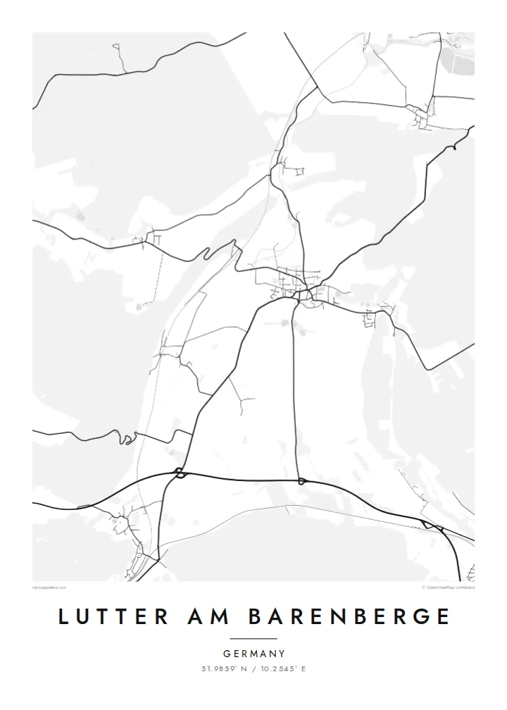
Several local roads meet in the village centre, giving the map a clear focal point from which lines radiate out across the surrounding farmland toward neighbouring villages.
བཟོ་རྣམ་འཇམ་ཏོང་ས་ཁྲའི་པོས་ཊར · ཇཱར་མ་ནི
51.9859° N / 10.2545° E
A small village core where country roads meet, framed by open fields and wooded higher ground on the northern edge of the Harz.
ཁྲོམ་གཅིག་ སེམས་ཁམས་ལྔ།
སྟའེལ་ཅིག་ལུ་ཨེབ་གཏང་འབད་ནི་ཨིནམ་ད་ཕྱག་ཤོག་གུར་ག་དེ་སྦེ་མཐོང་ནི་ཨིན་ན་བལྟ། སྟའེལ་ག་ར་གི་གོང་ཚད་གཅིག་མཚུངས་ཨིན། པར་བསྐྲུན་འབད་ཡོད་མི་དང་སྒམ་བཙུགས་ཡོད་མི་ནམ་ HD ཡིག་སྣོད་ཚུ་ཨིན་རུང་མཐུན་ཨིན།
 དངོས་སུའི་ pixels · 24 × 36″ པར་བསྐྲུན་ཡིག་སྣོད
དཔར་ནིའི་གསལ་ཚད།
འདི་དངོས་སུའི་པར་བསྐྲུན་ཡིག་སྣོད་ཀྱི་ ༡༠༠% ཁ་སྐོང་ཨིན། པར་བསྐྲུན་འབད་ཡོད་མི་དང་སྒམ་བཙུགས་ཡོད་མི་དང་ཕབ་ལེན་འབད་ཡོད་མི་ཕྱག་ཤོག་ག་ར་ང་བཅུད་ Server ལུ་ 300 DPI ནང་7,200 × 10,800 pixels་ཚུན་བཟོ་བཏོན་འབདཝ་ཨིནམ་ལས་ལམ་གནམ་མེད་ས་མེད་ཆུང་ཀུའི་ལམ་ཚུ་ཡང་ 24 × 36″ པར་བསྐྲུན་གུར་གསལ་བཏུབ་ཨིན།
རྩིག་པའི་གུར


ས་ཁྲ།
Lutter am Barenberge sits in the rolling country north of the Harz, in the district of Goslar in Lower Saxony. On a map the village reads as a compact cluster of streets where several roads converge, with farmland spreading out in broad, irregular parcels and patches of woodland rising toward the higher ground. The name itself points to a nearby hill, the Barenberg, a reminder that the landscape here is shaped by gentle relief rather than flat plain.
The place entered European history in August 1626, when the Battle of Lutter was fought nearby during the Thirty Years' War. Imperial and Catholic League troops under Tilly defeated the army of King Christian IV of Denmark, a defeat that sharply weakened the Danish role in the war. Little of that drama shows on paper today. What remains visible is the quiet agricultural pattern that surrounded the battlefield then and still does now.
Since 2021 Lutter has belonged to the town of Langelsheim, yet it keeps its own distinct outline. A Lutter am Barenberge map poster captures that outline in fine lines: the village streets at the centre, the lanes and field tracks running outward, and the softer texture of forest at the margins. It is a small place, and the poster treats it with the same care as any large city.
Several local roads meet in the village centre, giving the map a clear focal point from which lines radiate out across the surrounding farmland toward neighbouring villages.
Large agricultural parcels surround the built-up area, and their boundaries and tracks form a loose geometric background that contrasts with the denser streets of the village.
Wooded higher ground lies within reach of the village, and the Barenberg that gives Lutter its name hints at the rising terrain that eventually becomes the Harz to the south.
ཁྱོད་རའི་དོན་ལུ་བཟོ།
ཚེས་གྲངས་ མིང་ ཡང་ན་ ཁྱོད་རའི་ཚིག་ཐིག་ཅིག་བཙུགས། བཟོ་རྣམ་ ཚད་ ཡང་ན་ ཁ་ཕྱོགས་སོར།
རིན་མེད་ preview འདི་གྲངས་ཐིག་དམའ་ཞིང་ཡིག་རྟགས་དང་བཅས་ཨིན། པར་བསྐྲུན་དང་ HD ཡིག་སྣོད་ཚུ་ 300 DPI ནང་7,200 × 10,800 px་ཚུན་ཡིག་རྟགས་མེད་པར་བཟོ་བཏོན་འབདཝ་ཨིན།
ག་ཅི་འབད་ Lutter am Barenberge
For people with family roots in the Goslar district, or for anyone interested in the Thirty Years' War, this map is a quiet way to keep a specific place in view. It is less about spectacle than about recognising the lanes you know, drawn with clarity and restraint.
You can set your own title and subtitle, add a date such as a wedding or a move, and adjust the coordinates line. Choose between Classic black & white, Noir, Paper, Blueprint and Sand, then download HD files for $9 or order a printed poster.
Lutter am Barenberge ཕྱག་ཤོག་བཙུགས་བཏབ| དཔར་ཚད། | གསལ་ཚད། | ཡིག་སྣོད། |
|---|---|---|
| 30 × 40 cm11.8 × 15.7″ | 3,543 × 4,724 px | PNG · PDF |
| 29.7 × 42 cm (A3)11.7 × 16.5″ | 3,508 × 4,961 px | PNG · PDF |
| 42 × 59.4 cm (A2)16.5 × 23.4″ | 4,961 × 7,016 px | PNG · PDF |
| 45.7 × 61 cm18 × 24″ | 5,400 × 7,200 px | PNG · PDF |
| 50 × 70 cm19.7 × 27.6″ | 5,906 × 8,268 px | PNG · PDF |
| 61 × 91.4 cm24 × 36″ | 7,200 × 10,800 px | PNG · PDF |
ག་བསྡུར་འབད་བ་ཅིན་ རིན་མེད་སྔོན་ལྟ་འདི་ རྒྱ་ཚད་ 900 px ཡོདཔ་དང་ ཆུ་རྟགས་ཡོད་པའི་ གསལ་གཞི་ནང་བལྟ་ནིའི་དོན་ལུ་ཨིན། HD ཡིག་སྣོད་ཚུ་ ཁ་ཕྱོགས་རེ་རེ་ནང་ གསལ་ཚད་ 8× ཚུན་ཡོདཔ་ལས་ པོས་ཊར་ཚད་ཆ་ཚང་ནང་ གསལ་ཏོག་ཏོ་སྦེ་དཔར་ཚུགས།
ཤོག་ལེབ་གུར་སྟའེལ་ཅིག་སེལ་འཐུ་འབད་བའི་ཤུལ་ལས་ Printed Poster (ཚད་ཅིག་དང་དགོ་པ་ཅིན་སྒམ་ཅིག) ཡང་ན་ Digital HD Files སེལ་འཐུ་འབད། Checkout ལུ་གནས་སྐབས་གཅིག་རྐྱང་དགོཔ་ཨིནམ་ད་སྤྲོད་ལེན་ལེགས་ཤོམ་བྱུང་མ་ཐག་ ཁྱོད་རའི་བཙུགས་བཏབ་ཤོག་ལེབ་གསར་བཅོས་འབད་འོང་།
འདི་ 200 gsm matte ཤོག་བུ་ཡག་ཤོས་གུར་ 30 × 40 cm ལས་ 24 × 36″ ཚུན་ཚད་དྲུག་གི་ནང་ལས་གཅིག་ནང་པར་བསྐྲུན་འབདཝ་ཨིན། པར་བསྐྲུན་ཕྱག་ཤོག་ཚུ་ $39 ལས་འགོ་བཙུགསཔ་ཨིནམ་ད་འགྲེམ་སྤེལ་ཡང་ཚུད་ཡོདཔ་ཨིན།
བཏུབ་ཨིན། ཤིང་གི་སྒམ་ཚོས་གདོང་ནག་པོ་ཡང་ན་དཀར་པོ་ ཡང་ན་ oak ཐོན་ཁུངས་ ཡང་ན་ ཤིང་ནག་ཅིག་སེལ་འཐུ་འབད། འདི་ཤེལ་མི་བོར་མི་ཤོག་ཐང་དང་བཅས་བརྟེན་འོངམ་ཨིནམ་ད་ཨེབ་ནི་ལུ་གྲ་སྒྲིག་ཡོད། སྒམ་བཙུགས་ཡོད་མི་ཕྱག་ཤོག་ཚུ་ $99 ལས་འགོ་བཙུགསཔ་ཨིནམ་ད་འགྲེམ་སྤེལ་ཡང་ཚུད་ཡོདཔ་ཨིན།
རྒྱལ་ཁབ་ ༦༠+ ལུ་ སྐྱེལ་འདྲེན་ཁེ་མེད་ཨིན། པོ་སི་ཊར་ག་ར་ རྒྱལ་ཁབ་ ༣༠+ ནང་ལྷོད་པའི་ ང་བཅས་ཀྱི་ པར་འདེབས་མཉམ་གཅིག་པ་ཚུ་ ནང་ལས་ ཉེ་ཤོས་གཅིག་གིས་ པར་བཏབ་སྟེ་ སྤྱིར་བཏང་ལུ་ ལས་ཀའི་ཉིནམ་ ༣–༧ ནང་ལྷོད་ནི་ཨིན། གནས་སྟངས་དང་ རྗེས་འདེད་ཚུ་ “ངེའི་ཨོ་ཌར་” ནང་ལས་ བལྟ་ཚུགས། རྒྱལ་ཁབ་ལ་ལུ་ བདུན་ཕྲག་ ༢–༥ ཅིག་ འགོ་ནི་ཨིན། ད་ལྟོ་ཡང་ སྐྱེལ་མི་བཏུབ་པའི་ས་ཁོངས་ལུ་ དངུལ་སྤྲོད་མ་འབད་བའི་ཧེ་མར་ དྲ་ཚིགས་ཀྱིས་ ཁྱོད་ལུ་ གསལ་བཤད་འབདཝ་ཨིན།
ཐོབ་ཤུལ་ཉིན་གྲངས་ 14 གྱི་ནང་འཁོད་པར་ཅིག་བཏང་ ང་བཅས་ཀྱིས་རིན་མེད་ཐོག་ལས་སླར་པར་བསྐྲུན་འབད་འོང་ ཡང་ན་སོང་ཡོད་མི་སྤྲོད་འོང་།
བཏུབ་ཨིན། ཤོག་ལེབ་འདི་གུར་ Editor ནང་མགོ་མིང་དང་མགོ་མིང་འོག་མ་དེ་ལས་ལོངས་ཚད་ཡིག་ཐིག་དེ་ག་ཅི་འབད་ཡང་བསྒྱུར་བཅོས་འབད་དེ་སྟའེལ་དང་ཚད་ཅིག་སེལ་འཐུ་འབད། པར་བསྐྲུན་དང་སྒམ་བཙུགས་དང་ digital བཙུགས་བཏབ་ཚུ་ག་ར་ཁྱོད་རའི་བཟོ་རྣམ་དེ་རྐྱངམ་ཅིག་བེད་སྤྱོད་འབད་འོང་།
$9 ཐོག་ལས་ 300 DPI PNG དང་པར་བསྐྲུན་ལུ་གྲ་སྒྲིག་འབད་ཡོད་མི་ PDF ཡིག་སྣོད་ཚུ་ཚད་དྲུག་ཆ་མཉམ་ ཡིག་རྟགས་མེད་པར་ཐོབ་ནི་ཨིནམ་ད་གནས་ག་ཏེ་ལུ་ཡང་པར་བསྐྲུན་འབད་བཏུབ། ང་བཅས་ལུ་ཡིད་ཆེས་མེད་པ་ཅིན་ཡིག་རྟགས་ཡོད་མི་ rin med preview ཅིག་ཧེ་མ་ཕབ་ལེན་འབད་བལྟ།
ཉེ་འདབས།
