Central crossroads
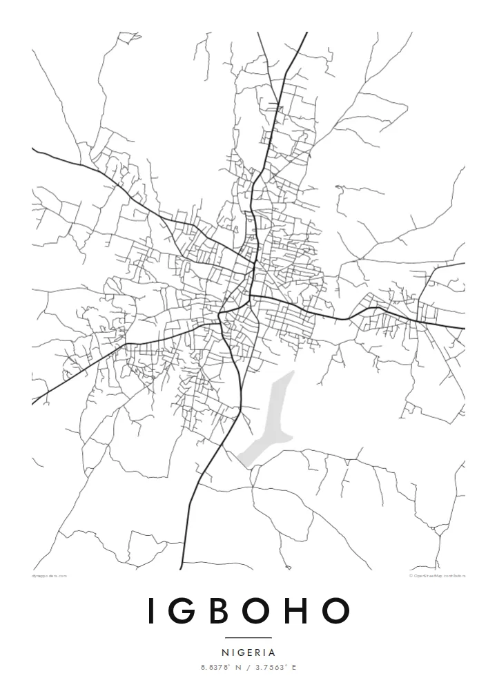
The main roads into town converge near the older core. This junction is the visual anchor of the map, and the rest of Igboho grows out from it in every direction.
Minimalistlik kaardiplakat · Nigeeria
8.8378° N / 3.7563° E
A savanna town of red-earth roads and scattered compounds, its streets radiating loosely across the open Oke-Ogun plains.


Üks linn, viis meeleolu
Puuduta stiili, et näha seda seinal. Kõik stiilid maksavad sama — trükituna, raamis või HD-failidena.
 Tegelikud pikslid · 24 × 36″ trükifail
Trükiteravus
See on 100% väljalõige tegelikust trükifailist. Iga poster — trükituna, raamis või allalaaditud — renderdatakse meie serverites 300 DPI juures, kuni 7,200 × 10,800 pikslini, nii et isegi kõige väiksemad teed püsivad 24 × 36″ trükisel teravad.
Seinal


Kaart
Igboho is in the Oke-Ogun area of northern Oyo State. Here the forest thins into open savanna, and the towns sit far apart along long, straight roads. From above, the town is a loose, organic spread rather than a planned grid. Main roads meet near the old centre, and around them clusters of compounds and smaller lanes fan out, gradually giving way to farmland and bush.
The town has a firm place in Yoruba history. When the Oyo kingdom was driven from its capital, Oyo-Ile, Igboho became the seat of the Alaafins for a period, and several of them are remembered as having been buried there. Today it is the headquarters of Oorelope Local Government Area, and it is a market and farming centre for the surrounding countryside.
An Igboho map poster shows a town that has grown outward from its crossroads. Seen from above, the roads cut clean diagonals across the plain, and the small streets between them form an irregular, hand-drawn texture. With so few large rivers or hills in the frame, the pattern of settlement itself becomes the subject, rendered in fine lines on open space.
The main roads into town converge near the older core. This junction is the visual anchor of the map, and the rest of Igboho grows out from it in every direction.
Between the main roads, short lanes and paths link family compounds in an irregular weave. It is a dense, organic texture that contrasts with the straight regional highways.
Beyond the built-up area the map opens into farmland and savanna. The surrounding space gives the town clear edges and a strong silhouette on the page.
Tee see enda omaks
Lisa kuupäev, nimi või oma tekst, vaheta stiili, suurust või suunda.
Tasuta eelvaade on madala eraldusvõimega ja veetempliga. Trükised ja HD-failid renderdatakse 300 DPI juures, kuni 7,200 × 10,800 px, ilma veetempliteta.
Miks Igboho
For people from Igboho, and for its many families living elsewhere in Nigeria and abroad, a map of the town is a direct link to home, to the compound, the market and the roads that lead back to them.
Personalise the title, subtitle and coordinates line with a family name, a quarter or a meaningful date, and pick one of five styles: Classic black and white, Noir, Paper, Blueprint or Sand. Sand suits the warm savanna setting.
Telli Igboho poster| Trükisuurus | Eraldusvõime | Failid |
|---|---|---|
| 30 × 40 cm (11.8 × 15.7″) | 3,543 × 4,724 px | PNG · PDF |
| 29.7 × 42 cm (A3, 11.7 × 16.5″) | 3,508 × 4,961 px | PNG · PDF |
| 42 × 59.4 cm (A2, 16.5 × 23.4″) | 4,961 × 7,016 px | PNG · PDF |
| 45.7 × 61 cm (18 × 24″) | 5,400 × 7,200 px | PNG · PDF |
| 50 × 70 cm (19.7 × 27.6″) | 5,906 × 8,268 px | PNG · PDF |
| 61 × 91.4 cm (24 × 36″) | 7,200 × 10,800 px | PNG · PDF |
Võrdluseks: tasuta eelvaade on 900 px lai, vesimärgiga ja mõeldud ekraanil vaatamiseks. HD-failidel on kuni 8× suurem eraldusvõime mõlemas suunas ja need prinditakse puhtalt ka täissuuruses plakatina.
Vali lehe ülaosas stiil ja seejärel Trükitud poster — suurus ja soovi korral raam — või Digitaalsed HD-failid. Tellimuse vormistamine võtab ühe sammu ning tellimuse leht uueneb kohe, kui makse on läbi läinud.
See trükitakse kvaliteetsele 200 gsm mattpaberile ühes kuuest suurusest, alates 30 × 40 cm kuni 24 × 36″. Trükitud postrite hind algab {printFrom}, tarne on hinnas sees.
Jah. Vali täispuidust raam mustas, valges, naturaalses tammes või tumedas puidutoonis. Raamiga kaasneb purunemiskindel klaas ning see on kohe seinale riputamiseks valmis. Raamitud postrite hind algab {framedFrom}, tarne on hinnas sees.
Tarne on kõikjal maailmas tasuta. Iga poster trükitakse meie lähima trükipartneri juures enam kui 30 riigis ning jõuab tavaliselt kohale 3–7 tööpäevaga. Oleku ja jälgimise leiad rubriigist Minu tellimused.
Saada meile foto 14 päeva jooksul pärast kohaletoimetamist ning me trükime posteri tasuta uuesti või tagastame raha.
Jah. Selle lehe redaktoris saad muuta pealkirja, alapealkirja ja koordinaatide rida enda soovi järgi ning valida stiili ja suuruse. Nii trükitud, raamitud kui ka digitaalsed tellimused kasutavad täpselt sinu kujundust.
$9 eest saad 300 DPI PNG- ja trükivalmis PDF-failid kõigis kuues suuruses, ilma veetempliteta, et trükkida kus iganes. Ei ole veel kindel? Laadi enne alla tasuta veetempliga eelvaade.
Läheduses
