Low, level plain
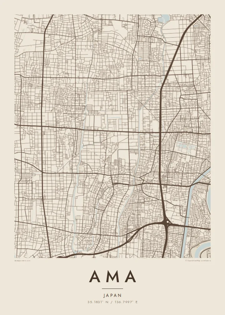
Ama lies on flat ground near sea level, so water channels and field boundaries shape the map instead of slopes. The result is an unusually even, finely detailed surface.
پوستر نقشه مینیمال · ژاپن
35.1831° N / 136.7997° E
Flat, low-lying land west of Nagoya, where neighbourhoods, rice fields and water channels meet in a fine grain.


یک شهر، پنج حالوهوا
روی یک سبک ضربه بزنید تا آن را روی دیوار ببینید. همه سبکها قیمت یکسانی دارند — چاپی، قابشده یا فایلهای HD.
 پیکسل واقعی · فایل چاپی ۲۴ × ۳۶ اینچ
وضوح چاپی
این یک برش ۱۰۰٪ از فایل چاپی واقعی است. هر پوستر — چاپی، قابشده یا دانلودی — روی سرورهای ما با کیفیت 300 DPI و تا 7,200 × 10,800 پیکسل رندر میشود، به همین دلیل حتی ریزترین خیابانها هم روی چاپ ۲۴ × ۳۶ اینچ واضح میمانند.
روی دیوار


نقشه
Ama is a city in western Aichi Prefecture, just beyond the edge of Nagoya on the flat Nōbi Plain. It was formed in 2010 when the towns of Shippō, Miwa and Jimokuji merged, and its map still reflects those older centres. Several clusters of streets are connected by rail lines and roads, with farmland and housing filling the space between them.
The land is almost completely level, much of it close to sea level, so drainage channels and small rivers shape the pattern rather than hills. Rectangular rice fields, straight irrigation lines and tight residential lanes combine into a fine, even texture. Commuter railways run through the city towards central Nagoya and tie Ama closely to the wider metropolitan area.
The name Shippō refers to cloisonné enamel, a craft long associated with the area, and Jimokuji is known for its old Buddhist temple of the same name. An Ama map poster shows this quiet suburban landscape clearly: the grain of fields and houses, the lines of rail and water, and the gentle rhythm of a low plain.
Ama lies on flat ground near sea level, so water channels and field boundaries shape the map instead of slopes. The result is an unusually even, finely detailed surface.
The older cores of Shippō, Miwa and Jimokuji appear as denser clusters of streets. They give the city several focal points instead of a single downtown.
Commuter lines cut across the city towards central Nagoya. They draw clean, straight strokes through the fields and neighbourhoods and connect Ama to the wider region.
شخصیسازی کنید
یک تاریخ، یک نام یا جملهای از خودتان اضافه کنید و سبک، اندازه یا جهت را تغییر دهید.
پیشنمایش رایگان کیفیت پایین و دارای واترمارک است. نسخههای چاپی و فایلهای HD با کیفیت 300 DPI، تا 7,200 × 10,800 پیکسل و بدون واترمارک رندر میشوند.
چرا Ama
Many people in Ama commute into Nagoya and come home each evening to a quieter place of fields and temples. A map of the city captures that balance and makes a thoughtful gift for a new home or for a family moving away.
You can change the title, subtitle and coordinates line to mark a neighbourhood, a date or a name. Pick from five styles: Classic black & white, Noir, Paper, Blueprint and Sand. The fine field pattern looks particularly good in Paper and Blueprint.
سفارش پوستر Ama| اندازه چاپ | وضوح | فایلها |
|---|---|---|
| 30 × 40 cm (11.8 × 15.7″) | 3,543 × 4,724 px | PNG · PDF |
| 29.7 × 42 cm (A3, 11.7 × 16.5″) | 3,508 × 4,961 px | PNG · PDF |
| 42 × 59.4 cm (A2, 16.5 × 23.4″) | 4,961 × 7,016 px | PNG · PDF |
| 45.7 × 61 cm (18 × 24″) | 5,400 × 7,200 px | PNG · PDF |
| 50 × 70 cm (19.7 × 27.6″) | 5,906 × 8,268 px | PNG · PDF |
| 61 × 91.4 cm (24 × 36″) | 7,200 × 10,800 px | PNG · PDF |
برای مقایسه، پیشنمایش رایگان ۹۰۰ پیکسل عرض دارد، واترمارکدار است و برای نمایش روی صفحه در نظر گرفته شده. فایلهای HD در هر جهت تا ۸ برابر وضوح بیشتری دارند و در اندازه کامل پوستر بهخوبی چاپ میشوند.
یک سبک را از بالای صفحه انتخاب کنید، سپس پوستر چاپی — یک اندازه و در صورت تمایل یک قاب — یا فایلهای دیجیتال HD را انتخاب کنید. پرداخت فقط یک مرحله دارد و صفحه سفارش شما به محض تکمیل پرداخت بهروزرسانی میشود.
روی کاغذ مات پرمیوم ۲۰۰ گرمی و در یکی از شش اندازه، از ۳۰ × ۴۰ سانتیمتر تا ۲۴ × ۳۶ اینچ، چاپ میشود. قیمت پوسترهای چاپی از {printFrom} شروع میشود و هزینه ارسال هم شامل آن است.
بله. یک قاب چوب طبیعی به رنگ مشکی، سفید، بلوط طبیعی یا چوب تیره انتخاب کنید. این قاب با شیشه ضدشکست عرضه میشود و آماده نصب است. قیمت پوسترهای قابشده از {framedFrom} شروع میشود و هزینه ارسال هم شامل آن است.
ارسال در سراسر جهان رایگان است. هر پوستر توسط نزدیکترین شریک چاپ ما در بیش از ۳۰ کشور چاپ میشود و معمولاً طی ۳ تا ۷ روز کاری میرسد. میتوانید وضعیت و رهگیری سفارش را در بخش سفارشهای من دنبال کنید.
ظرف ۱۴ روز از تحویل، یک عکس برای ما بفرستید تا آن را بهصورت رایگان دوباره چاپ کنیم یا هزینهتان را بازگردانیم.
بله. در ویرایشگر همین صفحه، عنوان، زیرعنوان و خط مختصات را به دلخواه تغییر دهید و یک سبک و اندازه انتخاب کنید. سفارشهای چاپی، قابشده و دیجیتال همگی دقیقاً از طرح شما استفاده میکنند.
با $9 فایلهای PNG با کیفیت 300 DPI و فایلهای PDF آماده چاپ را در هر شش اندازه، بدون واترمارک، دریافت میکنید تا هر جا خواستید چاپ کنید. هنوز مطمئن نیستید؟ ابتدا یک پیشنمایش رایگان با واترمارک دانلود کنید.
