Kalamos headland
A massive limestone rock forms the island's eastern tip. On the map it reads as a sharp, heavy promontory, a counterweight to the rounded hills of the rest of the island.
پوستر نقشه مینیمال · یونان
36.3734° N / 25.7929° E
A small, rugged Cycladic island with a hilltop village and a great limestone headland reaching out to the southeast


یک شهر، پنج حالوهوا
روی یک سبک ضربه بزنید تا آن را روی دیوار ببینید. همه سبکها قیمت یکسانی دارند — چاپی، قابشده یا فایلهای HD.
 پیکسل واقعی · فایل چاپی ۲۴ × ۳۶ اینچ
وضوح چاپی
این یک برش ۱۰۰٪ از فایل چاپی واقعی است. هر پوستر — چاپی، قابشده یا دانلودی — روی سرورهای ما با کیفیت 300 DPI و تا 7,200 × 10,800 پیکسل رندر میشود، به همین دلیل حتی ریزترین خیابانها هم روی چاپ ۲۴ × ۳۶ اینچ واضح میمانند.
روی دیوار


نقشه
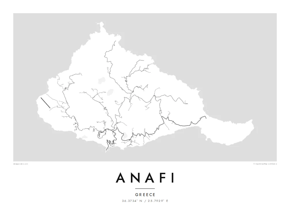
From above, Anafi looks like a compact knot of hills that ends in a long eastern arm. Roads are few and short. They climb from the small harbour to the white village of Chora on its ridge, then thin into footpaths that follow the valleys down to sheltered beaches on the south coast. Most of the island is bare slope, so the contour of the coastline carries most of the drawing.
The eastern arm ends at Kalamos, a huge limestone rock that rises straight from the sea and is often counted among the largest monoliths in the Mediterranean. A monastery sits high on its flank. In Greek myth, Apollo made the island appear out of the sea to shelter the Argonauts in a storm, and its name is usually linked to that moment of appearing.
An Anafi map poster works because there is so little on it. There is the harbour, a single winding road, the cluster of Chora and a scatter of chapels and tracks across the hills. Around it all, the Aegean fills the frame. Anafi lies just east of Santorini, but the map shows a much quieter place: an island measured in footpaths rather than streets.
A massive limestone rock forms the island's eastern tip. On the map it reads as a sharp, heavy promontory, a counterweight to the rounded hills of the rest of the island.
The main village sits high above the harbour, a tight cluster of lanes joined to the sea by one looping road. It is the densest set of lines on the whole island.
A row of small bays along the southern shore is reached by paths rather than roads. They cut a gentle scalloped edge into the coastline.
شخصیسازی کنید
یک تاریخ، یک نام یا جملهای از خودتان اضافه کنید و سبک، اندازه یا جهت را تغییر دهید.
پیشنمایش رایگان کیفیت پایین و دارای واترمارک است. نسخههای چاپی و فایلهای HD با کیفیت 300 DPI، تا 7,200 × 10,800 پیکسل و بدون واترمارک رندر میشوند.
چرا Anafi
Anafi tends to stay with people who went looking for the quieter end of the Cyclades, walked its paths and caught the ferry onward with some reluctance. The spare outline suits a calm wall, and the dark sea of the Noir style frames the island especially well.
Put your own words in the title and subtitle, such as the year you arrived or the name of the beach you walked to, and choose from five styles: Classic black & white, Noir, Paper, Blueprint or Sand. Download the HD files for $9, or order a matte print.
سفارش پوستر Anafi| اندازه چاپ | وضوح | فایلها |
|---|---|---|
| 30 × 40 cm (11.8 × 15.7″) | 3,543 × 4,724 px | PNG · PDF |
| 29.7 × 42 cm (A3, 11.7 × 16.5″) | 3,508 × 4,961 px | PNG · PDF |
| 42 × 59.4 cm (A2, 16.5 × 23.4″) | 4,961 × 7,016 px | PNG · PDF |
| 45.7 × 61 cm (18 × 24″) | 5,400 × 7,200 px | PNG · PDF |
| 50 × 70 cm (19.7 × 27.6″) | 5,906 × 8,268 px | PNG · PDF |
| 61 × 91.4 cm (24 × 36″) | 7,200 × 10,800 px | PNG · PDF |
برای مقایسه، پیشنمایش رایگان ۹۰۰ پیکسل عرض دارد، واترمارکدار است و برای نمایش روی صفحه در نظر گرفته شده. فایلهای HD در هر جهت تا ۸ برابر وضوح بیشتری دارند و در اندازه کامل پوستر بهخوبی چاپ میشوند.
یک سبک را از بالای صفحه انتخاب کنید، سپس پوستر چاپی — یک اندازه و در صورت تمایل یک قاب — یا فایلهای دیجیتال HD را انتخاب کنید. پرداخت فقط یک مرحله دارد و صفحه سفارش شما به محض تکمیل پرداخت بهروزرسانی میشود.
روی کاغذ مات پرمیوم ۲۰۰ گرمی و در یکی از شش اندازه، از ۳۰ × ۴۰ سانتیمتر تا ۲۴ × ۳۶ اینچ، چاپ میشود. قیمت پوسترهای چاپی از {printFrom} شروع میشود و هزینه ارسال هم شامل آن است.
بله. یک قاب چوب طبیعی به رنگ مشکی، سفید، بلوط طبیعی یا چوب تیره انتخاب کنید. این قاب با شیشه ضدشکست عرضه میشود و آماده نصب است. قیمت پوسترهای قابشده از {framedFrom} شروع میشود و هزینه ارسال هم شامل آن است.
ارسال در سراسر جهان رایگان است. هر پوستر توسط نزدیکترین شریک چاپ ما در بیش از ۳۰ کشور چاپ میشود و معمولاً طی ۳ تا ۷ روز کاری میرسد. میتوانید وضعیت و رهگیری سفارش را در بخش سفارشهای من دنبال کنید.
ظرف ۱۴ روز از تحویل، یک عکس برای ما بفرستید تا آن را بهصورت رایگان دوباره چاپ کنیم یا هزینهتان را بازگردانیم.
بله. در ویرایشگر همین صفحه، عنوان، زیرعنوان و خط مختصات را به دلخواه تغییر دهید و یک سبک و اندازه انتخاب کنید. سفارشهای چاپی، قابشده و دیجیتال همگی دقیقاً از طرح شما استفاده میکنند.
با $9 فایلهای PNG با کیفیت 300 DPI و فایلهای PDF آماده چاپ را در هر شش اندازه، بدون واترمارک، دریافت میکنید تا هر جا خواستید چاپ کنید. هنوز مطمئن نیستید؟ ابتدا یک پیشنمایش رایگان با واترمارک دانلود کنید.
