Stepped hillside
Streets switch back and forth up the steep slopes behind the bay, producing a dense, looping pattern that thins out as the land rises toward the mountains.
پوستر نقشه مینیمال · ژاپن
35.0883° N / 139.0532° E
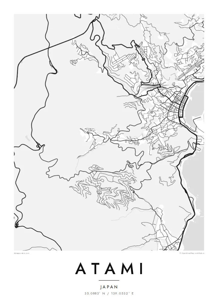
A hot-spring town climbing steep slopes above Sagami Bay, its streets twisting between hillsides, the shoreline and a small curved harbour.


یک شهر، پنج حالوهوا
روی یک سبک ضربه بزنید تا آن را روی دیوار ببینید. همه سبکها قیمت یکسانی دارند — چاپی، قابشده یا فایلهای HD.
 پیکسل واقعی · فایل چاپی ۲۴ × ۳۶ اینچ
وضوح چاپی
این یک برش ۱۰۰٪ از فایل چاپی واقعی است. هر پوستر — چاپی، قابشده یا دانلودی — روی سرورهای ما با کیفیت 300 DPI و تا 7,200 × 10,800 پیکسل رندر میشود، به همین دلیل حتی ریزترین خیابانها هم روی چاپ ۲۴ × ۳۶ اینچ واضح میمانند.
روی دیوار


نقشه
Atami sits at the northern edge of the Izu Peninsula, where the mountains drop almost straight into Sagami Bay. There is little flat land, so the town rises in layers up the slopes, with streets zigzagging to reach hotels, homes and viewpoints. From above, the plan is dense near the water and increasingly fragmented as it climbs the hillside.
The town has been known for its hot springs for centuries and became a popular resort in the modern era, helped by the Tokaido Shinkansen, which stops here on the way between Tokyo and western Japan. On an Atami map poster, the rail line and tunnels cut through the hills in firm straight lines against the tangled local streets.
Along the waterfront, a narrow strip of promenade, beach and harbour faces the bay, and the coastline curves around toward neighbouring inlets. Offshore, small islands sit in the water beyond the harbour. The combination of steep terrain, winding streets and open sea gives Atami one of the most sculptural outlines of any Japanese coastal town.
Streets switch back and forth up the steep slopes behind the bay, producing a dense, looping pattern that thins out as the land rises toward the mountains.
The high-speed rail line passes through the town in tunnels and cuttings, drawing a strong, straight line across the irregular hillside street pattern.
A short curved waterfront, beach and harbour face Sagami Bay, giving the map a clean coastal edge against the open water.
شخصیسازی کنید
یک تاریخ، یک نام یا جملهای از خودتان اضافه کنید و سبک، اندازه یا جهت را تغییر دهید.
پیشنمایش رایگان کیفیت پایین و دارای واترمارک است. نسخههای چاپی و فایلهای HD با کیفیت 300 DPI، تا 7,200 × 10,800 پیکسل و بدون واترمارک رندر میشوند.
چرا Atami
Atami is a place of holidays, family trips and quiet weekends by the sea. A map of its steep streets and curved bay makes a fitting keepsake for anyone who has stayed there or has ties to the Izu coast.
The title and subtitle can be changed to a name, a hotel, a date or a short phrase, in English or Japanese. Blueprint emphasises the sea, while Noir makes the dense hillside streets stand out sharply.
سفارش پوستر Atami| اندازه چاپ | وضوح | فایلها |
|---|---|---|
| 30 × 40 cm (11.8 × 15.7″) | 3,543 × 4,724 px | PNG · PDF |
| 29.7 × 42 cm (A3, 11.7 × 16.5″) | 3,508 × 4,961 px | PNG · PDF |
| 42 × 59.4 cm (A2, 16.5 × 23.4″) | 4,961 × 7,016 px | PNG · PDF |
| 45.7 × 61 cm (18 × 24″) | 5,400 × 7,200 px | PNG · PDF |
| 50 × 70 cm (19.7 × 27.6″) | 5,906 × 8,268 px | PNG · PDF |
| 61 × 91.4 cm (24 × 36″) | 7,200 × 10,800 px | PNG · PDF |
برای مقایسه، پیشنمایش رایگان ۹۰۰ پیکسل عرض دارد، واترمارکدار است و برای نمایش روی صفحه در نظر گرفته شده. فایلهای HD در هر جهت تا ۸ برابر وضوح بیشتری دارند و در اندازه کامل پوستر بهخوبی چاپ میشوند.
یک سبک را از بالای صفحه انتخاب کنید، سپس پوستر چاپی — یک اندازه و در صورت تمایل یک قاب — یا فایلهای دیجیتال HD را انتخاب کنید. پرداخت فقط یک مرحله دارد و صفحه سفارش شما به محض تکمیل پرداخت بهروزرسانی میشود.
روی کاغذ مات پرمیوم ۲۰۰ گرمی و در یکی از شش اندازه، از ۳۰ × ۴۰ سانتیمتر تا ۲۴ × ۳۶ اینچ، چاپ میشود. قیمت پوسترهای چاپی از {printFrom} شروع میشود و هزینه ارسال هم شامل آن است.
بله. یک قاب چوب طبیعی به رنگ مشکی، سفید، بلوط طبیعی یا چوب تیره انتخاب کنید. این قاب با شیشه ضدشکست عرضه میشود و آماده نصب است. قیمت پوسترهای قابشده از {framedFrom} شروع میشود و هزینه ارسال هم شامل آن است.
ارسال در سراسر جهان رایگان است. هر پوستر توسط نزدیکترین شریک چاپ ما در بیش از ۳۰ کشور چاپ میشود و معمولاً طی ۳ تا ۷ روز کاری میرسد. میتوانید وضعیت و رهگیری سفارش را در بخش سفارشهای من دنبال کنید.
ظرف ۱۴ روز از تحویل، یک عکس برای ما بفرستید تا آن را بهصورت رایگان دوباره چاپ کنیم یا هزینهتان را بازگردانیم.
بله. در ویرایشگر همین صفحه، عنوان، زیرعنوان و خط مختصات را به دلخواه تغییر دهید و یک سبک و اندازه انتخاب کنید. سفارشهای چاپی، قابشده و دیجیتال همگی دقیقاً از طرح شما استفاده میکنند.
با $9 فایلهای PNG با کیفیت 300 DPI و فایلهای PDF آماده چاپ را در هر شش اندازه، بدون واترمارک، دریافت میکنید تا هر جا خواستید چاپ کنید. هنوز مطمئن نیستید؟ ابتدا یک پیشنمایش رایگان با واترمارک دانلود کنید.
