Champion Bay
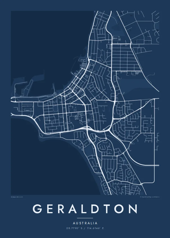
The bay curves gently along the city's front, sheltered by Point Moore, and forms the most recognisable shape on any map of Geraldton.
پوستر نقشه مینیمال · استرالیا
28.7790° S / 114.6146° E
A port city on Champion Bay, where a long Indian Ocean coast meets a sheltered harbour and wide suburbs.



یک شهر، پنج حالوهوا
روی یک سبک ضربه بزنید تا آن را روی دیوار ببینید. همه سبکها قیمت یکسانی دارند — چاپی، قابشده یا فایلهای HD.
 پیکسل واقعی · فایل چاپی ۲۴ × ۳۶ اینچ
وضوح چاپی
این یک برش ۱۰۰٪ از فایل چاپی واقعی است. هر پوستر — چاپی، قابشده یا دانلودی — روی سرورهای ما با کیفیت 300 DPI و تا 7,200 × 10,800 پیکسل رندر میشود، به همین دلیل حتی ریزترین خیابانها هم روی چاپ ۲۴ × ۳۶ اینچ واضح میمانند.
روی دیوار


نقشه
Geraldton sits on the Indian Ocean coast of Western Australia, about 420 kilometres north of Perth, on the shores of Champion Bay. On a map the city stretches along the coast for many kilometres, with the harbour and the curve of Point Moore forming a sheltered notch and suburbs spreading inland across low dunes and sandplain.
The port handles grain and minerals from the Mid West, and the city is closely tied to the western rock lobster industry. Offshore lie the Houtman Abrolhos Islands, known for their reefs and for the wreck of the Batavia in 1629. On the hill above town, the HMAS Sydney II Memorial marks the loss of the warship and its crew in 1941.
Geraldton's centre is laid out on a grid facing the foreshore, with St Francis Xavier Cathedral a well-known landmark nearby. A Geraldton map poster captures the long coastline, the harbour breakwaters and the orderly suburban streets in a composition shaped by wind, sand and sea, with plenty of open water to balance the land.
The bay curves gently along the city's front, sheltered by Point Moore, and forms the most recognisable shape on any map of Geraldton.
The port's breakwaters and wharves project into the bay in crisp straight lines, a strong industrial detail against the soft curve of the beach.
Residential streets extend for kilometres along the coast, with dune ridges and reserves between them, giving the map a long, linear character.
شخصیسازی کنید
یک تاریخ، یک نام یا جملهای از خودتان اضافه کنید و سبک، اندازه یا جهت را تغییر دهید.
پیشنمایش رایگان کیفیت پایین و دارای واترمارک است. نسخههای چاپی و فایلهای HD با کیفیت 300 DPI، تا 7,200 × 10,800 پیکسل و بدون واترمارک رندر میشوند.
چرا Geraldton
People keep this map because they grew up in the Mid West, worked on the lobster boats or at the port, or moved to the coast for the light and space. The long shoreline makes a clean, confident print.
Personalise the title, add a date or family name in the subtitle and edit the coordinates line. Choose Classic black & white, Noir, Paper, Blueprint or Sand. The $9 HD files come in six sizes, or order a printed poster shipped from a partner closer to home.
سفارش پوستر Geraldton| اندازه چاپ | وضوح | فایلها |
|---|---|---|
| 30 × 40 cm (11.8 × 15.7″) | 3,543 × 4,724 px | PNG · PDF |
| 29.7 × 42 cm (A3, 11.7 × 16.5″) | 3,508 × 4,961 px | PNG · PDF |
| 42 × 59.4 cm (A2, 16.5 × 23.4″) | 4,961 × 7,016 px | PNG · PDF |
| 45.7 × 61 cm (18 × 24″) | 5,400 × 7,200 px | PNG · PDF |
| 50 × 70 cm (19.7 × 27.6″) | 5,906 × 8,268 px | PNG · PDF |
| 61 × 91.4 cm (24 × 36″) | 7,200 × 10,800 px | PNG · PDF |
برای مقایسه، پیشنمایش رایگان ۹۰۰ پیکسل عرض دارد، واترمارکدار است و برای نمایش روی صفحه در نظر گرفته شده. فایلهای HD در هر جهت تا ۸ برابر وضوح بیشتری دارند و در اندازه کامل پوستر بهخوبی چاپ میشوند.
یک سبک را از بالای صفحه انتخاب کنید، سپس پوستر چاپی — یک اندازه و در صورت تمایل یک قاب — یا فایلهای دیجیتال HD را انتخاب کنید. پرداخت فقط یک مرحله دارد و صفحه سفارش شما به محض تکمیل پرداخت بهروزرسانی میشود.
روی کاغذ مات پرمیوم ۲۰۰ گرمی و در یکی از شش اندازه، از ۳۰ × ۴۰ سانتیمتر تا ۲۴ × ۳۶ اینچ، چاپ میشود. قیمت پوسترهای چاپی از {printFrom} شروع میشود و هزینه ارسال هم شامل آن است.
بله. یک قاب چوب طبیعی به رنگ مشکی، سفید، بلوط طبیعی یا چوب تیره انتخاب کنید. این قاب با شیشه ضدشکست عرضه میشود و آماده نصب است. قیمت پوسترهای قابشده از {framedFrom} شروع میشود و هزینه ارسال هم شامل آن است.
ارسال در سراسر جهان رایگان است. هر پوستر توسط نزدیکترین شریک چاپ ما در بیش از ۳۰ کشور چاپ میشود و معمولاً طی ۳ تا ۷ روز کاری میرسد. میتوانید وضعیت و رهگیری سفارش را در بخش سفارشهای من دنبال کنید.
ظرف ۱۴ روز از تحویل، یک عکس برای ما بفرستید تا آن را بهصورت رایگان دوباره چاپ کنیم یا هزینهتان را بازگردانیم.
بله. در ویرایشگر همین صفحه، عنوان، زیرعنوان و خط مختصات را به دلخواه تغییر دهید و یک سبک و اندازه انتخاب کنید. سفارشهای چاپی، قابشده و دیجیتال همگی دقیقاً از طرح شما استفاده میکنند.
با $9 فایلهای PNG با کیفیت 300 DPI و فایلهای PDF آماده چاپ را در هر شش اندازه، بدون واترمارک، دریافت میکنید تا هر جا خواستید چاپ کنید. هنوز مطمئن نیستید؟ ابتدا یک پیشنمایش رایگان با واترمارک دانلود کنید.
