Galata Bridge
The lowest crossing near the mouth links Eminönü with Karaköy. It is the busiest point on the water, and its outline marks the entrance to the inlet.
پوستر نقشه مینیمال · ترکیه
41.0412° N / 28.9551° E
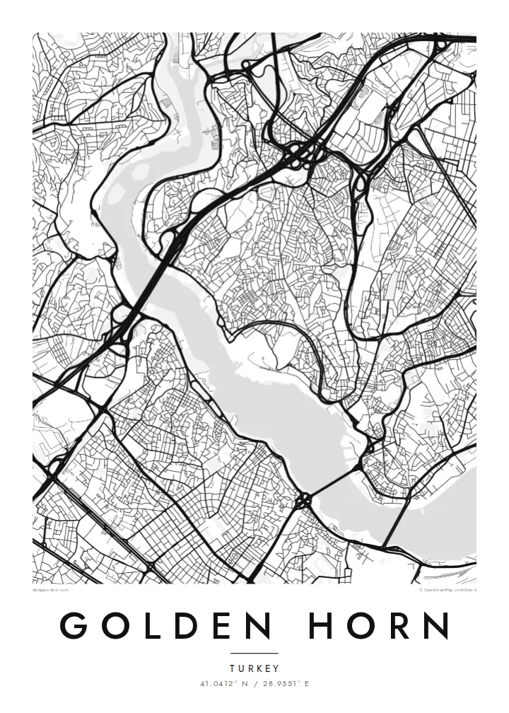
A long, curved estuary cutting into Istanbul's European side, crossed by bridges and lined on both banks with old quarters


یک شهر، پنج حالوهوا
روی یک سبک ضربه بزنید تا آن را روی دیوار ببینید. همه سبکها قیمت یکسانی دارند — چاپی، قابشده یا فایلهای HD.
 پیکسل واقعی · فایل چاپی ۲۴ × ۳۶ اینچ
وضوح چاپی
این یک برش ۱۰۰٪ از فایل چاپی واقعی است. هر پوستر — چاپی، قابشده یا دانلودی — روی سرورهای ما با کیفیت 300 DPI و تا 7,200 × 10,800 پیکسل رندر میشود، به همین دلیل حتی ریزترین خیابانها هم روی چاپ ۲۴ × ۳۶ اینچ واضح میمانند.
روی دیوار


نقشه
The Golden Horn is a narrow inlet that curves north-west from the Bosphorus for several kilometres. It separates Istanbul's historic peninsula from Galata and Beyoğlu on the far shore. On a map, its shape explains the name: a slender, horn-like body of water, wide at the mouth and tapering inland, where two streams feed into it.
For centuries this was one of the finest natural harbours in the Mediterranean world. In Byzantine times, a great chain was stretched across its mouth to keep enemy fleets out. The shores were later lined with shipyards, warehouses and dense neighbourhoods such as Fener and Balat, whose streets still come right down to the water on the southern bank.
Today several bridges cross the inlet, from the Galata Bridge near the mouth to the Atatürk Bridge and the Haliç metro bridge further in. A Golden Horn map poster places water at the centre of the composition. The city presses in from both sides, and the bridges stitch the two halves together in a series of fine lines.
The lowest crossing near the mouth links Eminönü with Karaköy. It is the busiest point on the water, and its outline marks the entrance to the inlet.
The inlet bends gently as it narrows inland. This gives the map a long, sweeping body of water rather than the straight line of a river.
These historic neighbourhoods on the southern bank climb from the waterline in a tight mesh of streets. They show how closely the old city once lived with the harbour.
شخصیسازی کنید
یک تاریخ، یک نام یا جملهای از خودتان اضافه کنید و سبک، اندازه یا جهت را تغییر دهید.
پیشنمایش رایگان کیفیت پایین و دارای واترمارک است. نسخههای چاپی و فایلهای HD با کیفیت 300 DPI، تا 7,200 × 10,800 پیکسل و بدون واترمارک رندر میشوند.
چرا Golden Horn
Anyone who has crossed the Galata Bridge at dusk or taken a ferry up the inlet knows how much of Istanbul is defined by water. This map puts the Golden Horn at the centre, just as the city does.
You can change the title, subtitle and coordinates line to mark a trip, a move or a family story. Pick one of five styles. Blueprint emphasises the water as a clean field, while Noir makes the shorelines glow against a dark ground.
سفارش پوستر Golden Horn| اندازه چاپ | وضوح | فایلها |
|---|---|---|
| 30 × 40 cm11.8 × 15.7″ | 3,543 × 4,724 px | PNG · PDF |
| 29.7 × 42 cm (A3)11.7 × 16.5″ | 3,508 × 4,961 px | PNG · PDF |
| 42 × 59.4 cm (A2)16.5 × 23.4″ | 4,961 × 7,016 px | PNG · PDF |
| 45.7 × 61 cm18 × 24″ | 5,400 × 7,200 px | PNG · PDF |
| 50 × 70 cm19.7 × 27.6″ | 5,906 × 8,268 px | PNG · PDF |
| 61 × 91.4 cm24 × 36″ | 7,200 × 10,800 px | PNG · PDF |
برای مقایسه، پیشنمایش رایگان ۹۰۰ پیکسل عرض دارد، واترمارکدار است و برای نمایش روی صفحه در نظر گرفته شده. فایلهای HD در هر جهت تا ۸ برابر وضوح بیشتری دارند و در اندازه کامل پوستر بهخوبی چاپ میشوند.
یک سبک را از بالای صفحه انتخاب کنید، سپس پوستر چاپی — یک اندازه و در صورت تمایل یک قاب — یا فایلهای دیجیتال HD را انتخاب کنید. پرداخت فقط یک مرحله دارد و صفحه سفارش شما به محض تکمیل پرداخت بهروزرسانی میشود.
روی کاغذ مات پرمیوم ۲۰۰ گرمی و در یکی از شش اندازه، از ۳۰ × ۴۰ سانتیمتر تا ۲۴ × ۳۶ اینچ، چاپ میشود. قیمت پوسترهای چاپی از $39 شروع میشود و هزینه ارسال هم شامل آن است.
بله. یک قاب چوب طبیعی به رنگ مشکی، سفید، بلوط طبیعی یا چوب تیره انتخاب کنید. این قاب با شیشه ضدشکست عرضه میشود و آماده نصب است. قیمت پوسترهای قابشده از $99 شروع میشود و هزینه ارسال هم شامل آن است.
ارسال به بیش از ۶۰ کشور رایگان است. هر پوستر را نزدیکترین شریک چاپ ما در بیش از ۳۰ کشور چاپ میکند و معمولاً ظرف ۳ تا ۷ روز کاری میرسد. وضعیت سفارش و کد رهگیری را در «سفارشهای من» میبینید. ارسال به چند کشور ۲ تا ۵ هفته طول میکشد و اگر هنوز به کشوری ارسال نداشته باشیم، سایت پیش از پرداخت به شما اطلاع میدهد.
ظرف ۱۴ روز از تحویل، یک عکس برای ما بفرستید تا آن را بهصورت رایگان دوباره چاپ کنیم یا هزینهتان را بازگردانیم.
بله. در ویرایشگر همین صفحه، عنوان، زیرعنوان و خط مختصات را به دلخواه تغییر دهید و یک سبک و اندازه انتخاب کنید. سفارشهای چاپی، قابشده و دیجیتال همگی دقیقاً از طرح شما استفاده میکنند.
با $9 فایلهای PNG با کیفیت 300 DPI و فایلهای PDF آماده چاپ را در هر شش اندازه، بدون واترمارک، دریافت میکنید تا هر جا خواستید چاپ کنید. هنوز مطمئن نیستید؟ ابتدا یک پیشنمایش رایگان با واترمارک دانلود کنید.
در همین نزدیکی
