Whanganui River
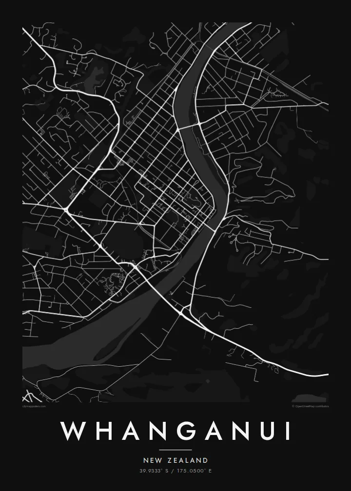
The river enters in broad loops and flows past the centre to the sea. Its wide, curving course gives the poster a strong natural line against the straight streets on either side.
پوستر نقشه مینیمال · نیوزیلند
39.9333° S / 175.0500° E
A river city on New Zealand's west coast, gathered around the last broad bends of the Whanganui before the Tasman Sea.



یک شهر، پنج حالوهوا
روی یک سبک ضربه بزنید تا آن را روی دیوار ببینید. همه سبکها قیمت یکسانی دارند — چاپی، قابشده یا فایلهای HD.
 پیکسل واقعی · فایل چاپی ۲۴ × ۳۶ اینچ
وضوح چاپی
این یک برش ۱۰۰٪ از فایل چاپی واقعی است. هر پوستر — چاپی، قابشده یا دانلودی — روی سرورهای ما با کیفیت 300 DPI و تا 7,200 × 10,800 پیکسل رندر میشود، به همین دلیل حتی ریزترین خیابانها هم روی چاپ ۲۴ × ۳۶ اینچ واضح میمانند.
روی دیوار


نقشه
Whanganui sits near the mouth of the Whanganui River on the southwest coast of the North Island. The river is the centre of the map: it sweeps in from the north in wide bends, passes the city centre and runs out to the Tasman Sea a few kilometres downstream. Streets spread across both banks, with the main commercial grid on the western side.
Several bridges link the two halves of the city, and on the eastern bank the ground rises sharply to Durie Hill, reached by a tunnel and an elevator opened in 1919. In 2017 the Whanganui River became the first river in the world to be recognised as a legal person, a status tied to its importance to local iwi. A Whanganui map poster puts that river at the heart of the design.
Away from the river, the city opens into a regular grid of suburbs, parks and reserves, with the coastline and dunes to the southwest. The centre keeps many Victorian and Edwardian buildings, though on the map it is the structure that matters: long straight streets meeting the soft curves of the water.
The river enters in broad loops and flows past the centre to the sea. Its wide, curving course gives the poster a strong natural line against the straight streets on either side.
On the eastern bank, the land climbs steeply. Streets there follow the contours, and the hill's elevator, built into the slope, links it to the river flats below.
Near the coast, the river meets the Tasman Sea between sandy shores and stone moles. Including the mouth in the frame adds a clean coastal edge to the composition.
شخصیسازی کنید
یک تاریخ، یک نام یا جملهای از خودتان اضافه کنید و سبک، اندازه یا جهت را تغییر دهید.
پیشنمایش رایگان کیفیت پایین و دارای واترمارک است. نسخههای چاپی و فایلهای HD با کیفیت 300 DPI، تا 7,200 × 10,800 پیکسل و بدون واترمارک رندر میشوند.
چرا Whanganui
Whanganui matters to people who grew up by the river, rowed on it or travelled its length by canoe. A map of the city keeps that bond in view with a simple, honest image of streets and water.
Choose a title in English or te reo Māori, add a subtitle such as a date, and edit the coordinates line if you wish. Five styles are available, from Classic black & white to Blueprint. Order a matte print or download the $9 HD files.
سفارش پوستر Whanganui| اندازه چاپ | وضوح | فایلها |
|---|---|---|
| 30 × 40 cm11.8 × 15.7″ | 3,543 × 4,724 px | PNG · PDF |
| 29.7 × 42 cm (A3)11.7 × 16.5″ | 3,508 × 4,961 px | PNG · PDF |
| 42 × 59.4 cm (A2)16.5 × 23.4″ | 4,961 × 7,016 px | PNG · PDF |
| 45.7 × 61 cm18 × 24″ | 5,400 × 7,200 px | PNG · PDF |
| 50 × 70 cm19.7 × 27.6″ | 5,906 × 8,268 px | PNG · PDF |
| 61 × 91.4 cm24 × 36″ | 7,200 × 10,800 px | PNG · PDF |
برای مقایسه، پیشنمایش رایگان ۹۰۰ پیکسل عرض دارد، واترمارکدار است و برای نمایش روی صفحه در نظر گرفته شده. فایلهای HD در هر جهت تا ۸ برابر وضوح بیشتری دارند و در اندازه کامل پوستر بهخوبی چاپ میشوند.
یک سبک را از بالای صفحه انتخاب کنید، سپس پوستر چاپی — یک اندازه و در صورت تمایل یک قاب — یا فایلهای دیجیتال HD را انتخاب کنید. پرداخت فقط یک مرحله دارد و صفحه سفارش شما به محض تکمیل پرداخت بهروزرسانی میشود.
روی کاغذ مات پرمیوم ۲۰۰ گرمی و در یکی از شش اندازه، از ۳۰ × ۴۰ سانتیمتر تا ۲۴ × ۳۶ اینچ، چاپ میشود. قیمت پوسترهای چاپی از $39 شروع میشود و هزینه ارسال هم شامل آن است.
بله. یک قاب چوب طبیعی به رنگ مشکی، سفید، بلوط طبیعی یا چوب تیره انتخاب کنید. این قاب با شیشه ضدشکست عرضه میشود و آماده نصب است. قیمت پوسترهای قابشده از $99 شروع میشود و هزینه ارسال هم شامل آن است.
ارسال به بیش از ۶۰ کشور رایگان است. هر پوستر را نزدیکترین شریک چاپ ما در بیش از ۳۰ کشور چاپ میکند و معمولاً ظرف ۳ تا ۷ روز کاری میرسد. وضعیت سفارش و کد رهگیری را در «سفارشهای من» میبینید. ارسال به چند کشور ۲ تا ۵ هفته طول میکشد و اگر هنوز به کشوری ارسال نداشته باشیم، سایت پیش از پرداخت به شما اطلاع میدهد.
ظرف ۱۴ روز از تحویل، یک عکس برای ما بفرستید تا آن را بهصورت رایگان دوباره چاپ کنیم یا هزینهتان را بازگردانیم.
بله. در ویرایشگر همین صفحه، عنوان، زیرعنوان و خط مختصات را به دلخواه تغییر دهید و یک سبک و اندازه انتخاب کنید. سفارشهای چاپی، قابشده و دیجیتال همگی دقیقاً از طرح شما استفاده میکنند.
با $9 فایلهای PNG با کیفیت 300 DPI و فایلهای PDF آماده چاپ را در هر شش اندازه، بدون واترمارک، دریافت میکنید تا هر جا خواستید چاپ کنید. هنوز مطمئن نیستید؟ ابتدا یک پیشنمایش رایگان با واترمارک دانلود کنید.
