The hill fort
The fort's walls climb the boulder-covered hill in successive rings. On the poster the hill is a broad open shape with only a few paths, which sets it clearly apart from the town below.
פוסטר מפה מינימליסטי · הודו
14.2226° N / 76.4004° E
A town wrapped around a granite hill fort, where boulder-strewn slopes and rings of stone walls push the streets outward.




עיר אחת, חמש אווירות
הקישו על סגנון כדי לראות אותו על הקיר. כל הסגנונות עולים אותו מחיר — מודפס, ממוסגר או כקבצי HD.
 פיקסלים אמיתיים · קובץ הדפסה 24 × 36″
חדות של הדפסה
זהו קטע בגודל 100% מקובץ ההדפסה האמיתי. כל פוסטר — מודפס, ממוסגר או מורד — מעובד בשרתים שלנו ברזולוציה של 300 DPI, עד 7,200 × 10,800 פיקסלים, כך שאפילו הרחובות הקטנים ביותר נשארים חדים בהדפסה בגודל 24 × 36″.
על הקיר


המפה
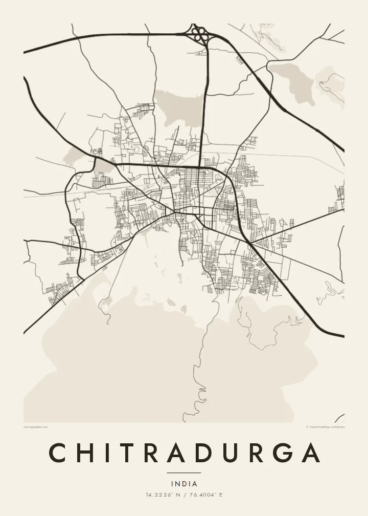
Chitradurga, a district headquarters in central Karnataka, grew at the foot of a rocky hill covered in enormous granite boulders. Crowning it is Chitradurga Fort, a stone fortress built up over several centuries and strengthened by the Nayaka rulers of the region. On a map the fort shows as a large, nearly empty area of hillside, with the town's streets crowded tightly around its lower edge.
The fort is known locally as Elu Suttina Kote, the fort of seven rounds, after its concentric lines of walls. One of the town's best-known stories concerns Onake Obavva, a woman remembered for defending a gap in the walls with a wooden pestle during a siege in the eighteenth century. The national highway between Bengaluru and Pune passes close to the town.
A Chitradurga map poster brings out an unusual composition. Where most towns have a dense centre, this one has a hollow of rock and ramparts surrounded by streets. In black and white the contrast is sharp: dense lanes on one side, the pale mass of the hill on the other, and the lines of fortification between them.
The fort's walls climb the boulder-covered hill in successive rings. On the poster the hill is a broad open shape with only a few paths, which sets it clearly apart from the town below.
The streets closest to the fort are narrow and irregular, following the curve of the hill's base. They are the most densely drawn part of the map.
The main highway runs past the town as a long, straight line. Its rigid course contrasts with the curving streets and the rough outline of the hill.
התאימו אישית
הוסיפו תאריך, שם או שורה משלכם, והחליפו סגנון, גודל או כיוון.
התצוגה המקדימה החינמית היא ברזולוציה נמוכה ועם סימן מים. ההדפסים וקבצי ה-HD מעובדים ברזולוציה של 300 DPI, עד 7,200 × 10,800 px, ללא סימן מים.
למה Chitradurga
Chitradurga is a strong choice for anyone with roots in the district, or for travellers who climbed the fort and remember the view over the rooftops. It reads well at larger sizes, where the rings of walls and the dense old streets have room to show.
The title, subtitle and coordinates line can all be changed, so the poster can name a family home, a college year or a special date. Choose one of five styles: Classic black & white, Noir, Paper, Blueprint or Sand. Noir makes the pale hill stand out especially clearly.
הזמינו את פוסטר Chitradurga| גודל הדפסה | רזולוציה | קבצים |
|---|---|---|
| 30 × 40 cm (11.8 × 15.7″) | 3,543 × 4,724 px | PNG · PDF |
| 29.7 × 42 cm (A3, 11.7 × 16.5″) | 3,508 × 4,961 px | PNG · PDF |
| 42 × 59.4 cm (A2, 16.5 × 23.4″) | 4,961 × 7,016 px | PNG · PDF |
| 45.7 × 61 cm (18 × 24″) | 5,400 × 7,200 px | PNG · PDF |
| 50 × 70 cm (19.7 × 27.6″) | 5,906 × 8,268 px | PNG · PDF |
| 61 × 91.4 cm (24 × 36″) | 7,200 × 10,800 px | PNG · PDF |
לשם השוואה, התצוגה המקדימה החינמית ברוחב 900 פיקסלים, עם סימן מים ומיועדת למסכים. לקובצי ה־HD רזולוציה גבוהה עד פי 8 בכל כיוון, והם מודפסים בצורה נקייה בגודל פוסטר מלא.
בחרו סגנון בראש העמוד, ואז בחרו פוסטר מודפס — גודל, ואם תרצו, גם מסגרת — או קבצי HD דיגיטליים. התשלום מתבצע בשלב אחד, ועמוד ההזמנה שלכם מתעדכן ברגע שהתשלום מאושר.
הוא מודפס על נייר מאט פרימיום במשקל 200 גרם, באחד משישה גדלים, מ-30 × 40 ס״מ ועד 24 × 36″. פוסטרים מודפסים מתחילים ב-$39, כולל משלוח.
כן. בחרו מסגרת מעץ מלא בשחור, לבן, אלון טבעי או עץ כהה. המסגרת מגיעה עם זכוכית בטיחותית ומוכנה לתלייה. פוסטרים ממוסגרים מתחילים ב-$99, כולל משלוח.
המשלוח חינם בכל העולם. כל פוסטר מודפס אצל שותף ההדפסה הקרוב ביותר אליכם, מבין שותפינו ביותר מ-30 מדינות, ובדרך כלל מגיע תוך 3–7 ימי עסקים. את הסטטוס ומעקב המשלוח אפשר לראות ב"ההזמנות שלי". למדינות מסוימות המשלוח לוקח 2–5 שבועות, ובמדינות שאליהן אנחנו עוד לא שולחים, האתר יודיע לכם לפני התשלום.
שלחו לנו תמונה תוך 14 יום מקבלת המשלוח, ואנחנו נדפיס אותו מחדש בחינם או נחזיר לכם את הכסף.
כן. בעורך שבעמוד הזה אפשר לשנות את הכותרת, כותרת המשנה ושורת הקואורדינטות לכל מה שתרצו, ולבחור סגנון וגודל. הזמנות מודפסות, ממוסגרות ודיגיטליות משתמשות בדיוק בעיצוב שלכם.
תמורת $9 תקבלו קבצי PNG ו-PDF מוכנים להדפסה ברזולוציה של 300 DPI, בכל שישה הגדלים, ללא סימן מים, להדפסה בכל מקום. עוד לא בטוחים? הורידו קודם תצוגה מקדימה חינמית עם סימן מים.
