Port Vila lagoons
Around the capital, lagoons push inland between streets and headlands. On the poster they create a delicate pattern of water and land at the island's southwest corner.
פוסטר מפה מינימליסטי · ונואטו
17.6739° S / 168.3762° E
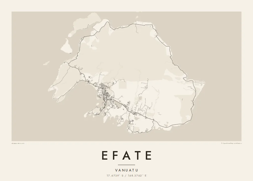
A rounded tropical island ringed by one coastal road, with Port Vila's harbour and lagoons tucked into its southwest corner.




עיר אחת, חמש אווירות
הקישו על סגנון כדי לראות אותו על הקיר. כל הסגנונות עולים אותו מחיר — מודפס, ממוסגר או כקבצי HD.
 פיקסלים אמיתיים · קובץ הדפסה 24 × 36″
חדות של הדפסה
זהו קטע בגודל 100% מקובץ ההדפסה האמיתי. כל פוסטר — מודפס, ממוסגר או מורד — מעובד בשרתים שלנו ברזולוציה של 300 DPI, עד 7,200 × 10,800 פיקסלים, כך שאפילו הרחובות הקטנים ביותר נשארים חדים בהדפסה בגודל 24 × 36″.
על הקיר


המפה
Efate is the most populous island of Vanuatu and home to its capital, Port Vila. Its outline is compact and rounded, broken by several large bays and harbours, while the interior is hilly and forested. A sealed ring road follows the coast all the way around the island, linking villages, plantations and beaches in a single loop that shows clearly on the map.
Port Vila spreads along a sheltered harbour on the southwest coast, beside Mele Bay and a series of lagoons, including Erakor and Emten, that reach deep into the town. To the northwest, Havannah Harbour served as a naval anchorage during the Second World War. Chief Roi Mata's Domain, a UNESCO World Heritage site, lies on Efate and the nearby islands of Lelepa and Artok.
An Efate map poster pairs the small, intricate street network of the capital with the long, simple sweep of the ring road. Offshore islands scatter around the coast, and the lagoons around Port Vila add softer, rounded shapes to the composition. It is a map of a capital city and of a quiet island at the same time.
Around the capital, lagoons push inland between streets and headlands. On the poster they create a delicate pattern of water and land at the island's southwest corner.
A single road circles the whole island near the coast. It forms a continuous loop on the map, tying together the capital and the villages along the shore.
A broad, sheltered stretch of water on the northwest coast, protected by offshore islands. It gives the island's outline one of its most distinctive indentations.
התאימו אישית
הוסיפו תאריך, שם או שורה משלכם, והחליפו סגנון, גודל או כיוון.
התצוגה המקדימה החינמית היא ברזולוציה נמוכה ועם סימן מים. ההדפסים וקבצי ה-HD מעובדים ברזולוציה של 300 DPI, עד 7,200 × 10,800 px, ללא סימן מים.
למה Efate
Efate is home to many families in Vanuatu and a place of posting or long stays for others, from aid workers to sailors. A poster of the island captures the capital and its surroundings in one clear shape, easy to recognise from across a room.
You can personalise the title and subtitle, add a date or a neighbourhood, and set the coordinates line. Five styles are available: Classic black & white, Noir, Paper, Blueprint and Sand. Printed posters are shipped from partners in more than 30 countries.
הזמינו את פוסטר Efate| גודל הדפסה | רזולוציה | קבצים |
|---|---|---|
| 30 × 40 cm (11.8 × 15.7″) | 3,543 × 4,724 px | PNG · PDF |
| 29.7 × 42 cm (A3, 11.7 × 16.5″) | 3,508 × 4,961 px | PNG · PDF |
| 42 × 59.4 cm (A2, 16.5 × 23.4″) | 4,961 × 7,016 px | PNG · PDF |
| 45.7 × 61 cm (18 × 24″) | 5,400 × 7,200 px | PNG · PDF |
| 50 × 70 cm (19.7 × 27.6″) | 5,906 × 8,268 px | PNG · PDF |
| 61 × 91.4 cm (24 × 36″) | 7,200 × 10,800 px | PNG · PDF |
לשם השוואה, התצוגה המקדימה החינמית ברוחב 900 פיקסלים, עם סימן מים ומיועדת למסכים. לקובצי ה־HD רזולוציה גבוהה עד פי 8 בכל כיוון, והם מודפסים בצורה נקייה בגודל פוסטר מלא.
בחרו סגנון בראש העמוד, ואז בחרו פוסטר מודפס — גודל, ואם תרצו, גם מסגרת — או קבצי HD דיגיטליים. התשלום מתבצע בשלב אחד, ועמוד ההזמנה שלכם מתעדכן ברגע שהתשלום מאושר.
הוא מודפס על נייר מאט פרימיום במשקל 200 גרם, באחד משישה גדלים, מ-30 × 40 ס״מ ועד 24 × 36″. פוסטרים מודפסים מתחילים ב-{printFrom}, כולל משלוח.
כן. בחרו מסגרת מעץ מלא בשחור, לבן, אלון טבעי או עץ כהה. המסגרת מגיעה עם זכוכית בטיחותית ומוכנה לתלייה. פוסטרים ממוסגרים מתחילים ב-{framedFrom}, כולל משלוח.
המשלוח חינם בכל העולם. כל פוסטר מודפס אצל שותף ההדפסה הקרוב ביותר מבין למעלה מ-30 מדינות, ולרוב מגיע תוך 3–7 ימי עסקים. אפשר לעקוב אחרי הסטטוס והמעקב בעמוד ההזמנות שלי.
שלחו לנו תמונה תוך 14 יום מקבלת המשלוח, ואנחנו נדפיס אותו מחדש בחינם או נחזיר לכם את הכסף.
כן. בעורך שבעמוד הזה אפשר לשנות את הכותרת, כותרת המשנה ושורת הקואורדינטות לכל מה שתרצו, ולבחור סגנון וגודל. הזמנות מודפסות, ממוסגרות ודיגיטליות משתמשות בדיוק בעיצוב שלכם.
תמורת $9 תקבלו קבצי PNG ו-PDF מוכנים להדפסה ברזולוציה של 300 DPI, בכל שישה הגדלים, ללא סימן מים, להדפסה בכל מקום. עוד לא בטוחים? הורידו קודם תצוגה מקדימה חינמית עם סימן מים.
