The historic crescent
The original 1930s town curves along a ridge in a broad arc, with housing rows and roads following the shape of the land.
פוסטר מפה מינימליסטי · ארצות הברית
39.0046° N / 76.8755° W
A New Deal planned town of crescent-shaped superblocks, footpaths and a wooded lake, enclosed by a band of green


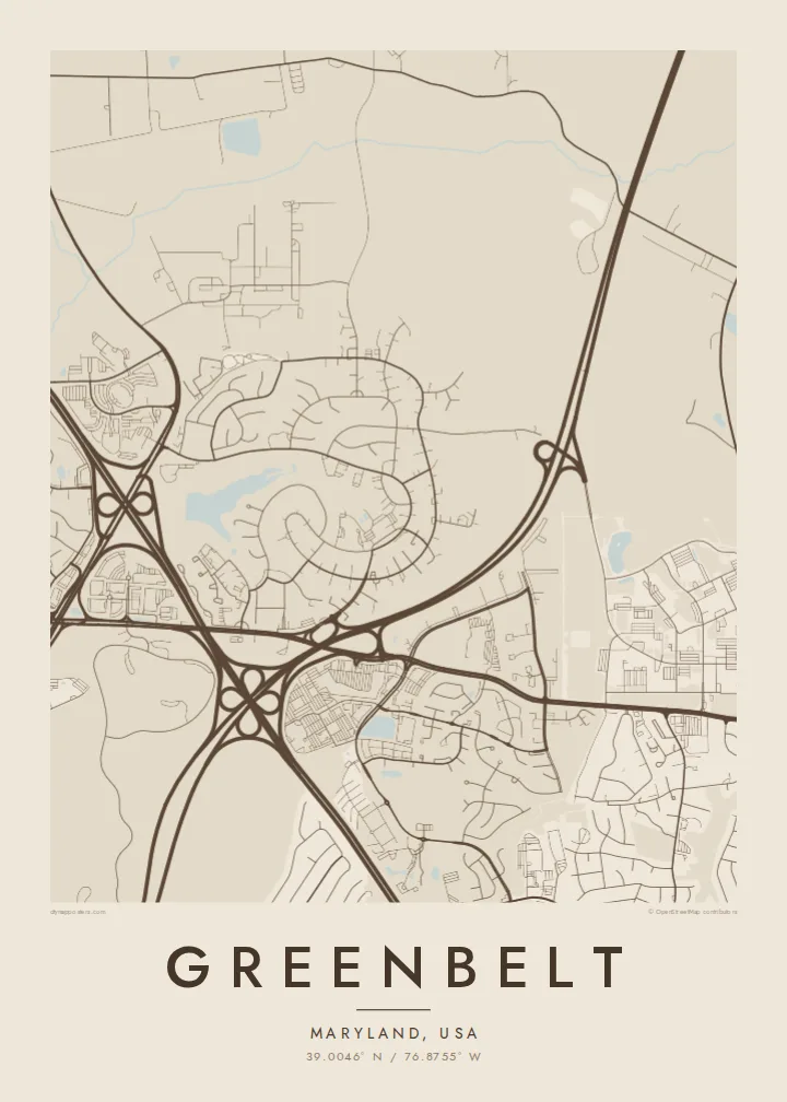
עיר אחת, חמש אווירות
הקישו על סגנון כדי לראות אותו על הקיר. כל הסגנונות עולים אותו מחיר — מודפס, ממוסגר או כקבצי HD.
 פיקסלים אמיתיים · קובץ הדפסה 24 × 36″
חדות של הדפסה
זהו קטע בגודל 100% מקובץ ההדפסה האמיתי. כל פוסטר — מודפס, ממוסגר או מורד — מעובד בשרתים שלנו ברזולוציה של 300 DPI, עד 7,200 × 10,800 פיקסלים, כך שאפילו הרחובות הקטנים ביותר נשארים חדים בהדפסה בגודל 24 × 36″.
על הקיר


המפה
Greenbelt, Maryland, northeast of Washington, D.C., was built in the late 1930s as one of three greenbelt towns planned by the federal government under the New Deal. Its original section is laid out as a gentle crescent that follows a natural ridge. Rows of housing sit within large superblocks, and a network of footpaths lets residents walk to the town centre without crossing major roads.
That design is still clear from above. Curving roads trace the crescent, interior walkways link the blocks, and Roosevelt Center, the original commercial and civic heart, sits near the middle. Greenbelt Lake and its surrounding woods add a wide area of open space. Later developments, highways and the nearby Goddard Space Flight Center fill in the wider area.
A Greenbelt map poster is especially rewarding for anyone interested in urban planning. The original town reads almost like a diagram of an idea: homes, paths, a centre and a ring of green. In black and white the crescent form and the calm spaces of lake and forest make one of the most distinctive street patterns in the Washington region.
The original 1930s town curves along a ridge in a broad arc, with housing rows and roads following the shape of the land.
Large blocks hold housing around shared green spaces, and interior walkways and underpasses let pedestrians move without crossing busy streets.
A lake set in woodland forms a soft, open area near the planned town, one of its most recognisable features on the map.
התאימו אישית
הוסיפו תאריך, שם או שורה משלכם, והחליפו סגנון, גודל או כיוון.
התצוגה המקדימה החינמית היא ברזולוציה נמוכה ועם סימן מים. ההדפסים וקבצי ה-HD מעובדים ברזולוציה של 300 DPI, עד 7,200 × 10,800 px, ללא סימן מים.
למה Greenbelt
Greenbelt appeals to residents, to former residents and to anyone who admires planned communities. The map shows an idea of how people might live together, carried out in streets and paths and still recognisable almost a century later.
Add your own title, a subtitle such as the year you moved in, or coordinates of a specific court. Choose from Classic black & white, Noir, Paper, Blueprint and Sand. Order a printed poster or download the HD files for $9.
הזמינו את פוסטר Greenbelt| גודל הדפסה | רזולוציה | קבצים |
|---|---|---|
| 30 × 40 cm11.8 × 15.7″ | 3,543 × 4,724 px | PNG · PDF |
| 29.7 × 42 cm (A3)11.7 × 16.5″ | 3,508 × 4,961 px | PNG · PDF |
| 42 × 59.4 cm (A2)16.5 × 23.4″ | 4,961 × 7,016 px | PNG · PDF |
| 45.7 × 61 cm18 × 24″ | 5,400 × 7,200 px | PNG · PDF |
| 50 × 70 cm19.7 × 27.6″ | 5,906 × 8,268 px | PNG · PDF |
| 61 × 91.4 cm24 × 36″ | 7,200 × 10,800 px | PNG · PDF |
לשם השוואה, התצוגה המקדימה החינמית ברוחב 900 פיקסלים, עם סימן מים ומיועדת למסכים. לקובצי ה־HD רזולוציה גבוהה עד פי 8 בכל כיוון, והם מודפסים בצורה נקייה בגודל פוסטר מלא.
בחרו סגנון בראש העמוד, ואז בחרו פוסטר מודפס — גודל, ואם תרצו, גם מסגרת — או קבצי HD דיגיטליים. התשלום מתבצע בשלב אחד, ועמוד ההזמנה שלכם מתעדכן ברגע שהתשלום מאושר.
הוא מודפס על נייר מאט פרימיום במשקל 200 גרם, באחד משישה גדלים, מ-30 × 40 ס״מ ועד 24 × 36″. פוסטרים מודפסים מתחילים ב-$39, כולל משלוח.
כן. בחרו מסגרת מעץ מלא בשחור, לבן, אלון טבעי או עץ כהה. המסגרת מגיעה עם זכוכית בטיחותית ומוכנה לתלייה. פוסטרים ממוסגרים מתחילים ב-$99, כולל משלוח.
המשלוח חינם ליותר מ-60 מדינות. כל פוסטר מודפס אצל שותף ההדפסה הקרוב ביותר מבין שותפינו ביותר מ-30 מדינות, ובדרך כלל מגיע תוך 3–7 ימי עסקים. אפשר לעקוב אחר הסטטוס ומספר המעקב בעמוד ההזמנות שלי. במדינות מסוימות המשלוח אורך 2–5 שבועות, ואם אנחנו עדיין לא שולחים ליעד שלך, האתר יודיע לך על כך לפני התשלום.
שלחו לנו תמונה תוך 14 יום מקבלת המשלוח, ואנחנו נדפיס אותו מחדש בחינם או נחזיר לכם את הכסף.
כן. בעורך שבעמוד הזה אפשר לשנות את הכותרת, כותרת המשנה ושורת הקואורדינטות לכל מה שתרצו, ולבחור סגנון וגודל. הזמנות מודפסות, ממוסגרות ודיגיטליות משתמשות בדיוק בעיצוב שלכם.
תמורת $9 תקבלו קבצי PNG ו-PDF מוכנים להדפסה ברזולוציה של 300 DPI, בכל שישה הגדלים, ללא סימן מים, להדפסה בכל מקום. עוד לא בטוחים? הורידו קודם תצוגה מקדימה חינמית עם סימן מים.
בסביבה
