Balcón de Europa
The promontory at the heart of town projects into the Mediterranean like a small pier of rock, a sharp point on the coastline that gives the map its focal centre.
פוסטר מפה מינימליסטי · ספרד
36.7528° N / 3.8744° W
A cliff-top town on a scalloped coastline, cut by ravines and anchored by the Balcón de Europa promontory


עיר אחת, חמש אווירות
הקישו על סגנון כדי לראות אותו על הקיר. כל הסגנונות עולים אותו מחיר — מודפס, ממוסגר או כקבצי HD.
 פיקסלים אמיתיים · קובץ הדפסה 24 × 36″
חדות של הדפסה
זהו קטע בגודל 100% מקובץ ההדפסה האמיתי. כל פוסטר — מודפס, ממוסגר או מורד — מעובד בשרתים שלנו ברזולוציה של 300 DPI, עד 7,200 × 10,800 פיקסלים, כך שאפילו הרחובות הקטנים ביותר נשארים חדים בהדפסה בגודל 24 × 36″.
על הקיר


המפה
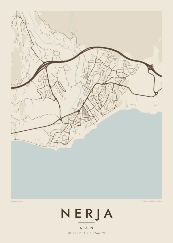
Nerja sits at the eastern end of the Málaga coast, where the Sierra Almijara drops steeply toward the Mediterranean. The town occupies a low plateau above the sea, and on a map its edge is anything but straight: small coves, rocky points and beaches alternate along the shore, each tucked between cliffs. Behind the town the mountains close in, leaving a narrow strip for streets and terraces.
At the centre of that coastline is the Balcón de Europa, a promontory that juts into the sea from the old town and forms the most recognisable point on any map of Nerja. Around it the historic streets are short and irregular. East of the centre, Burriana beach traces a long curve, and beyond it the river Chíllar cuts its valley down from the sierra.
Nerja is widely known for its caves, a vast cavern system discovered in 1959 just east of town near the village of Maro, now among the most visited sites in Andalusia. A Nerja map poster brings together the elements that make the place distinct from above: the jagged shore, the promontory, the ravines running to the sea and the mountain wall that frames it all.
The promontory at the heart of town projects into the Mediterranean like a small pier of rock, a sharp point on the coastline that gives the map its focal centre.
Between cliffs, a series of beaches and small coves gives the shoreline a scalloped outline, with Burriana forming the longest and most open curve east of the old town.
The Chíllar descends from the Sierra Almijara along the eastern side of town, its narrow valley tracing a line from the mountains down to the sea.
התאימו אישית
הוסיפו תאריך, שם או שורה משלכם, והחליפו סגנון, גודל או כיוון.
התצוגה המקדימה החינמית היא ברזולוציה נמוכה ועם סימן מים. ההדפסים וקבצי ה-HD מעובדים ברזולוציה של 300 DPI, עד 7,200 × 10,800 px, ללא סימן מים.
למה Nerja
Nerja is a place people return to year after year, and many Spaniards first saw it in the television series Verano azul, filmed here in the early 1980s. A map of the town is a way to keep those summers at home, from the promontory to the beach where you always swam.
Add a title and subtitle, perhaps the year you first came or the name of your street, and choose Classic black & white, Noir, Paper, Blueprint or Sand. Sand suits the coastline especially well. Get HD files for $9 or a matte printed poster, framed if you prefer.
הזמינו את פוסטר Nerja| גודל הדפסה | רזולוציה | קבצים |
|---|---|---|
| 30 × 40 cm (11.8 × 15.7″) | 3,543 × 4,724 px | PNG · PDF |
| 29.7 × 42 cm (A3, 11.7 × 16.5″) | 3,508 × 4,961 px | PNG · PDF |
| 42 × 59.4 cm (A2, 16.5 × 23.4″) | 4,961 × 7,016 px | PNG · PDF |
| 45.7 × 61 cm (18 × 24″) | 5,400 × 7,200 px | PNG · PDF |
| 50 × 70 cm (19.7 × 27.6″) | 5,906 × 8,268 px | PNG · PDF |
| 61 × 91.4 cm (24 × 36″) | 7,200 × 10,800 px | PNG · PDF |
לשם השוואה, התצוגה המקדימה החינמית ברוחב 900 פיקסלים, עם סימן מים ומיועדת למסכים. לקובצי ה־HD רזולוציה גבוהה עד פי 8 בכל כיוון, והם מודפסים בצורה נקייה בגודל פוסטר מלא.
בחרו סגנון בראש העמוד, ואז בחרו פוסטר מודפס — גודל, ואם תרצו, גם מסגרת — או קבצי HD דיגיטליים. התשלום מתבצע בשלב אחד, ועמוד ההזמנה שלכם מתעדכן ברגע שהתשלום מאושר.
הוא מודפס על נייר מאט פרימיום במשקל 200 גרם, באחד משישה גדלים, מ-30 × 40 ס״מ ועד 24 × 36″. פוסטרים מודפסים מתחילים ב-{printFrom}, כולל משלוח.
כן. בחרו מסגרת מעץ מלא בשחור, לבן, אלון טבעי או עץ כהה. המסגרת מגיעה עם זכוכית בטיחותית ומוכנה לתלייה. פוסטרים ממוסגרים מתחילים ב-{framedFrom}, כולל משלוח.
המשלוח חינם בכל העולם. כל פוסטר מודפס אצל שותף ההדפסה הקרוב ביותר מבין למעלה מ-30 מדינות, ולרוב מגיע תוך 3–7 ימי עסקים. אפשר לעקוב אחרי הסטטוס והמעקב בעמוד ההזמנות שלי.
שלחו לנו תמונה תוך 14 יום מקבלת המשלוח, ואנחנו נדפיס אותו מחדש בחינם או נחזיר לכם את הכסף.
כן. בעורך שבעמוד הזה אפשר לשנות את הכותרת, כותרת המשנה ושורת הקואורדינטות לכל מה שתרצו, ולבחור סגנון וגודל. הזמנות מודפסות, ממוסגרות ודיגיטליות משתמשות בדיוק בעיצוב שלכם.
תמורת $9 תקבלו קבצי PNG ו-PDF מוכנים להדפסה ברזולוציה של 300 DPI, בכל שישה הגדלים, ללא סימן מים, להדפסה בכל מקום. עוד לא בטוחים? הורידו קודם תצוגה מקדימה חינמית עם סימן מים.
