The crater harbour
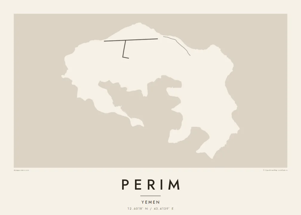
The island's core is a sheltered bay enclosed by curving arms of land, the flooded heart of an old volcano. It gives Perim its unmistakable horseshoe outline on the map.
פוסטר מפה מינימליסטי · תימן
12.6518° N / 43.4139° E
A small volcanic horseshoe in the Bab-el-Mandeb strait, curled around a sheltered natural harbour.




עיר אחת, חמש אווירות
הקישו על סגנון כדי לראות אותו על הקיר. כל הסגנונות עולים אותו מחיר — מודפס, ממוסגר או כקבצי HD.
 פיקסלים אמיתיים · קובץ הדפסה 24 × 36″
חדות של הדפסה
זהו קטע בגודל 100% מקובץ ההדפסה האמיתי. כל פוסטר — מודפס, ממוסגר או מורד — מעובד בשרתים שלנו ברזולוציה של 300 DPI, עד 7,200 × 10,800 פיקסלים, כך שאפילו הרחובות הקטנים ביותר נשארים חדים בהדפסה בגודל 24 × 36″.
על הקיר


המפה
Perim is a small island in the Bab-el-Mandeb, the strait that joins the Red Sea to the Gulf of Aden. It lies close to the Yemeni coast, in the narrow channel between Arabia and Africa. Its shape is the first thing you notice. The island is the remains of a volcanic crater, curled into a rough horseshoe around a deep, enclosed bay.
That natural harbour and the island's position on one of the world's busiest sea lanes gave Perim an outsized role in the past. In the late nineteenth and early twentieth centuries, the British used it as a coaling station for ships travelling between the Suez Canal and the Indian Ocean. Today it is sparsely inhabited, and it is known in Arabic as Mayun.
A Perim map poster is almost entirely about the coastline. The curved arms of the island wrap around the inner bay, and there is only a light scatter of lines on the land itself. Open water frames the island on all sides. The result is a spare, graphic shape that is easy to recognise at any size.
The island's core is a sheltered bay enclosed by curving arms of land, the flooded heart of an old volcano. It gives Perim its unmistakable horseshoe outline on the map.
Perim sits in the Bab-el-Mandeb, between the Arabian Peninsula and the Horn of Africa. At a wider framing, the poster shows the island guarding the narrow passage.
There are very few roads or buildings on the island. That leaves the land mostly blank, so the outline and inner harbour carry the entire composition.
התאימו אישית
הוסיפו תאריך, שם או שורה משלכם, והחליפו סגנון, גודל או כיוון.
התצוגה המקדימה החינמית היא ברזולוציה נמוכה ועם סימן מים. ההדפסים וקבצי ה-HD מעובדים ברזולוציה של 300 DPI, עד 7,200 × 10,800 px, ללא סימן מים.
למה Perim
Perim appeals to people drawn to maritime history, shipping routes and unusual geography. Its horseshoe shape is striking on its own, even for those who have never been there. It suits a study or office wall as a clean, almost abstract form with a real story behind it.
Add a title of your choosing, a subtitle and your own coordinates line, then pick from Classic black & white, Noir, Paper, Blueprint or Sand. The $9 digital download includes six sizes at 300 DPI with no watermark. Printed posters ship from partners in more than 30 countries.
הזמינו את פוסטר Perim| גודל הדפסה | רזולוציה | קבצים |
|---|---|---|
| 30 × 40 cm (11.8 × 15.7″) | 3,543 × 4,724 px | PNG · PDF |
| 29.7 × 42 cm (A3, 11.7 × 16.5″) | 3,508 × 4,961 px | PNG · PDF |
| 42 × 59.4 cm (A2, 16.5 × 23.4″) | 4,961 × 7,016 px | PNG · PDF |
| 45.7 × 61 cm (18 × 24″) | 5,400 × 7,200 px | PNG · PDF |
| 50 × 70 cm (19.7 × 27.6″) | 5,906 × 8,268 px | PNG · PDF |
| 61 × 91.4 cm (24 × 36″) | 7,200 × 10,800 px | PNG · PDF |
לשם השוואה, התצוגה המקדימה החינמית ברוחב 900 פיקסלים, עם סימן מים ומיועדת למסכים. לקובצי ה־HD רזולוציה גבוהה עד פי 8 בכל כיוון, והם מודפסים בצורה נקייה בגודל פוסטר מלא.
בחרו סגנון בראש העמוד, ואז בחרו פוסטר מודפס — גודל, ואם תרצו, גם מסגרת — או קבצי HD דיגיטליים. התשלום מתבצע בשלב אחד, ועמוד ההזמנה שלכם מתעדכן ברגע שהתשלום מאושר.
הוא מודפס על נייר מאט פרימיום במשקל 200 גרם, באחד משישה גדלים, מ-30 × 40 ס״מ ועד 24 × 36″. פוסטרים מודפסים מתחילים ב-$39, כולל משלוח.
כן. בחרו מסגרת מעץ מלא בשחור, לבן, אלון טבעי או עץ כהה. המסגרת מגיעה עם זכוכית בטיחותית ומוכנה לתלייה. פוסטרים ממוסגרים מתחילים ב-$99, כולל משלוח.
המשלוח חינם בכל העולם. כל פוסטר מודפס אצל שותף ההדפסה הקרוב ביותר אליכם, מבין שותפינו ביותר מ-30 מדינות, ובדרך כלל מגיע תוך 3–7 ימי עסקים. את הסטטוס ומעקב המשלוח אפשר לראות ב"ההזמנות שלי". למדינות מסוימות המשלוח לוקח 2–5 שבועות, ובמדינות שאליהן אנחנו עוד לא שולחים, האתר יודיע לכם לפני התשלום.
שלחו לנו תמונה תוך 14 יום מקבלת המשלוח, ואנחנו נדפיס אותו מחדש בחינם או נחזיר לכם את הכסף.
כן. בעורך שבעמוד הזה אפשר לשנות את הכותרת, כותרת המשנה ושורת הקואורדינטות לכל מה שתרצו, ולבחור סגנון וגודל. הזמנות מודפסות, ממוסגרות ודיגיטליות משתמשות בדיוק בעיצוב שלכם.
תמורת $9 תקבלו קבצי PNG ו-PDF מוכנים להדפסה ברזולוציה של 300 DPI, בכל שישה הגדלים, ללא סימן מים, להדפסה בכל מקום. עוד לא בטוחים? הורידו קודם תצוגה מקדימה חינמית עם סימן מים.
