The Kosi riverbed
The Kosi runs past the town in a wide, shifting bed of channels and gravel bars. It makes a broad pale band that sets the frame for everything around it.
פוסטר מפה מינימליסטי · הודו
29.3925° N / 79.1283° E
A foothill town beside the wide braided bed of the Kosi, where the plains stop and forested Kumaon ridges begin



עיר אחת, חמש אווירות
הקישו על סגנון כדי לראות אותו על הקיר. כל הסגנונות עולים אותו מחיר — מודפס, ממוסגר או כקבצי HD.
 פיקסלים אמיתיים · קובץ הדפסה 24 × 36″
חדות של הדפסה
זהו קטע בגודל 100% מקובץ ההדפסה האמיתי. כל פוסטר — מודפס, ממוסגר או מורד — מעובד בשרתים שלנו ברזולוציה של 300 DPI, עד 7,200 × 10,800 פיקסלים, כך שאפילו הרחובות הקטנים ביותר נשארים חדים בהדפסה בגודל 24 × 36″.
על הקיר


המפה
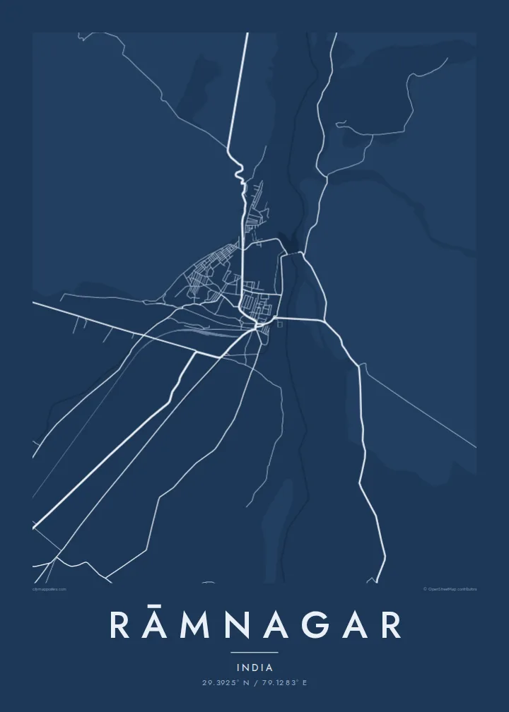
Rāmnagar sits right where the Gangetic plain meets the first ridges of the Kumaon Himalaya. On a map, the town's compact streets gather on the flat ground near the Kosi River. To the north and west the drawing turns almost empty, because forest takes over and roads become rare. The river's broad, braided channel is the strongest line on the sheet, curving down from the hills and spreading out as it reaches the plain.
The town is best known as the main gateway to Jim Corbett National Park, India's oldest national park, established in 1936. That explains the pattern of roads leaving town. A few routes head into the reserve and the hills, while others run south and east across farmland towards the plains. The contrast between a dense core and the open edges gives the layout a clear sense of place.
A Rāmnagar map poster shows that threshold in black and white. On one side there are the lanes and markets of a working town. On the other are the long pale spaces of river gravel and forest, crossed by only a few thin lines. It suits someone who has passed through on the way to Corbett, or who grew up in the town, where the mountains are always close.
The Kosi runs past the town in a wide, shifting bed of channels and gravel bars. It makes a broad pale band that sets the frame for everything around it.
Roads leave the compact centre in several directions, some towards the protected forest and hill country, others out across the plains. The town reads as a junction between two landscapes.
North and west of town the street network thins out quickly, marking where the Corbett landscape begins. On the poster that open space is as expressive as the streets.
התאימו אישית
הוסיפו תאריך, שם או שורה משלכם, והחליפו סגנון, גודל או כיוון.
התצוגה המקדימה החינמית היא ברזולוציה נמוכה ועם סימן מים. ההדפסים וקבצי ה-HD מעובדים ברזולוציה של 300 DPI, עד 7,200 × 10,800 px, ללא סימן מים.
למה Rāmnagar
For many people Rāmnagar is where a journey into the hills or a first safari began. A map of it keeps that moment in a quieter form. The river, the town and the edge of the forest sit on one sheet, which suits a hallway, a study or a cabin wall.
You can add your own title, a subtitle such as a trip date, and a coordinates line. Then choose one of five styles: Classic black & white, Noir, Paper, Blueprint or Sand. Sand and Paper suit the dry riverbed especially well.
הזמינו את פוסטר Rāmnagar| גודל הדפסה | רזולוציה | קבצים |
|---|---|---|
| 30 × 40 cm (11.8 × 15.7″) | 3,543 × 4,724 px | PNG · PDF |
| 29.7 × 42 cm (A3, 11.7 × 16.5″) | 3,508 × 4,961 px | PNG · PDF |
| 42 × 59.4 cm (A2, 16.5 × 23.4″) | 4,961 × 7,016 px | PNG · PDF |
| 45.7 × 61 cm (18 × 24″) | 5,400 × 7,200 px | PNG · PDF |
| 50 × 70 cm (19.7 × 27.6″) | 5,906 × 8,268 px | PNG · PDF |
| 61 × 91.4 cm (24 × 36″) | 7,200 × 10,800 px | PNG · PDF |
לשם השוואה, התצוגה המקדימה החינמית ברוחב 900 פיקסלים, עם סימן מים ומיועדת למסכים. לקובצי ה־HD רזולוציה גבוהה עד פי 8 בכל כיוון, והם מודפסים בצורה נקייה בגודל פוסטר מלא.
בחרו סגנון בראש העמוד, ואז בחרו פוסטר מודפס — גודל, ואם תרצו, גם מסגרת — או קבצי HD דיגיטליים. התשלום מתבצע בשלב אחד, ועמוד ההזמנה שלכם מתעדכן ברגע שהתשלום מאושר.
הוא מודפס על נייר מאט פרימיום במשקל 200 גרם, באחד משישה גדלים, מ-30 × 40 ס״מ ועד 24 × 36″. פוסטרים מודפסים מתחילים ב-{printFrom}, כולל משלוח.
כן. בחרו מסגרת מעץ מלא בשחור, לבן, אלון טבעי או עץ כהה. המסגרת מגיעה עם זכוכית בטיחותית ומוכנה לתלייה. פוסטרים ממוסגרים מתחילים ב-{framedFrom}, כולל משלוח.
המשלוח חינם בכל העולם. כל פוסטר מודפס אצל שותף ההדפסה הקרוב ביותר מבין למעלה מ-30 מדינות, ולרוב מגיע תוך 3–7 ימי עסקים. אפשר לעקוב אחרי הסטטוס והמעקב בעמוד ההזמנות שלי.
שלחו לנו תמונה תוך 14 יום מקבלת המשלוח, ואנחנו נדפיס אותו מחדש בחינם או נחזיר לכם את הכסף.
כן. בעורך שבעמוד הזה אפשר לשנות את הכותרת, כותרת המשנה ושורת הקואורדינטות לכל מה שתרצו, ולבחור סגנון וגודל. הזמנות מודפסות, ממוסגרות ודיגיטליות משתמשות בדיוק בעיצוב שלכם.
תמורת $9 תקבלו קבצי PNG ו-PDF מוכנים להדפסה ברזולוציה של 300 DPI, בכל שישה הגדלים, ללא סימן מים, להדפסה בכל מקום. עוד לא בטוחים? הורידו קודם תצוגה מקדימה חינמית עם סימן מים.
