Curving streets
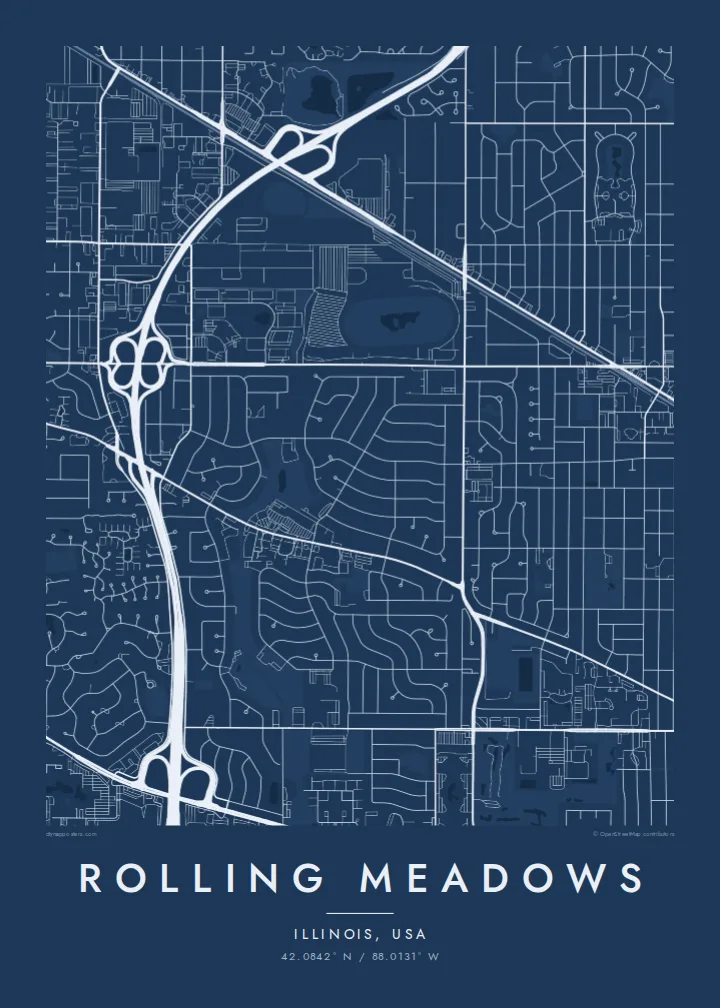
Most residential streets bend and loop instead of meeting at right angles. This hallmark of the town's 1950s planning gives the poster its defining texture.
פוסטר מפה מינימליסטי · ארצות הברית
42.0842° N / 88.0131° W
A postwar planned suburb northwest of Chicago, drawn in curving streets, looping crescents and the line of Salt Creek.



עיר אחת, חמש אווירות
הקישו על סגנון כדי לראות אותו על הקיר. כל הסגנונות עולים אותו מחיר — מודפס, ממוסגר או כקבצי HD.
 פיקסלים אמיתיים · קובץ הדפסה 24 × 36″
חדות של הדפסה
זהו קטע בגודל 100% מקובץ ההדפסה האמיתי. כל פוסטר — מודפס, ממוסגר או מורד — מעובד בשרתים שלנו ברזולוציה של 300 DPI, עד 7,200 × 10,800 פיקסלים, כך שאפילו הרחובות הקטנים ביותר נשארים חדים בהדפסה בגודל 24 × 36″.
על הקיר


המפה
Rolling Meadows lies in the northwest suburbs of Chicago, in Cook County, and began in the 1950s as a planned community on former farmland. Its founding developer laid out houses along gently curving streets instead of the rigid grid of older Chicago suburbs. That choice still defines the map, and loops, bends and quiet crescents fill most of the city.
Salt Creek winds through the city, bordered by strips of parkland and forest preserve that break up the residential pattern. Major arteries such as Illinois Route 53 and Algonquin Road cut straighter lines across the area. Office campuses and commercial blocks gather along them, so the edges of the map have a larger, more open scale than the neighbourhoods inside.
A Rolling Meadows map poster shows suburban planning at its most graphic. The curved streets produce a soft, almost organic pattern that looks quite different from the strict grid of the city to the southeast. It suits people who grew up here, new homeowners, and anyone who appreciates a well-drawn suburb.
Most residential streets bend and loop instead of meeting at right angles. This hallmark of the town's 1950s planning gives the poster its defining texture.
The creek meanders through the city, lined by green space, adding an irregular natural line that cuts across the orderly suburban layout.
The highway runs north to south through the area as a broad, straight band. It divides neighbourhoods and marks a clear axis on the map.
התאימו אישית
הוסיפו תאריך, שם או שורה משלכם, והחליפו סגנון, גודל או כיוון.
התצוגה המקדימה החינמית היא ברזולוציה נמוכה ועם סימן מים. ההדפסים וקבצי ה-HD מעובדים ברזולוציה של 300 DPI, עד 7,200 × 10,800 px, ללא סימן מים.
למה Rolling Meadows
A first house, a childhood street, a neighbourhood where family still lives: Rolling Meadows is often personal in that way. Its map turns the everyday route home into a clean graphic that feels considered rather than sentimental.
You can name the poster after your street or family, add a move-in date to the subtitle, and edit the coordinates line. Choose from five styles, including Classic black & white and Noir, and download the HD files for $9 or order a printed poster.
הזמינו את פוסטר Rolling Meadows| גודל הדפסה | רזולוציה | קבצים |
|---|---|---|
| 30 × 40 cm11.8 × 15.7″ | 3,543 × 4,724 px | PNG · PDF |
| 29.7 × 42 cm (A3)11.7 × 16.5″ | 3,508 × 4,961 px | PNG · PDF |
| 42 × 59.4 cm (A2)16.5 × 23.4″ | 4,961 × 7,016 px | PNG · PDF |
| 45.7 × 61 cm18 × 24″ | 5,400 × 7,200 px | PNG · PDF |
| 50 × 70 cm19.7 × 27.6″ | 5,906 × 8,268 px | PNG · PDF |
| 61 × 91.4 cm24 × 36″ | 7,200 × 10,800 px | PNG · PDF |
לשם השוואה, התצוגה המקדימה החינמית ברוחב 900 פיקסלים, עם סימן מים ומיועדת למסכים. לקובצי ה־HD רזולוציה גבוהה עד פי 8 בכל כיוון, והם מודפסים בצורה נקייה בגודל פוסטר מלא.
בחרו סגנון בראש העמוד, ואז בחרו פוסטר מודפס — גודל, ואם תרצו, גם מסגרת — או קבצי HD דיגיטליים. התשלום מתבצע בשלב אחד, ועמוד ההזמנה שלכם מתעדכן ברגע שהתשלום מאושר.
הוא מודפס על נייר מאט פרימיום במשקל 200 גרם, באחד משישה גדלים, מ-30 × 40 ס״מ ועד 24 × 36″. פוסטרים מודפסים מתחילים ב-$39, כולל משלוח.
כן. בחרו מסגרת מעץ מלא בשחור, לבן, אלון טבעי או עץ כהה. המסגרת מגיעה עם זכוכית בטיחותית ומוכנה לתלייה. פוסטרים ממוסגרים מתחילים ב-$99, כולל משלוח.
המשלוח חינם ליותר מ-60 מדינות. כל פוסטר מודפס אצל שותף ההדפסה הקרוב ביותר מבין שותפינו ביותר מ-30 מדינות, ובדרך כלל מגיע תוך 3–7 ימי עסקים. אפשר לעקוב אחר הסטטוס ומספר המעקב בעמוד ההזמנות שלי. במדינות מסוימות המשלוח אורך 2–5 שבועות, ואם אנחנו עדיין לא שולחים ליעד שלך, האתר יודיע לך על כך לפני התשלום.
שלחו לנו תמונה תוך 14 יום מקבלת המשלוח, ואנחנו נדפיס אותו מחדש בחינם או נחזיר לכם את הכסף.
כן. בעורך שבעמוד הזה אפשר לשנות את הכותרת, כותרת המשנה ושורת הקואורדינטות לכל מה שתרצו, ולבחור סגנון וגודל. הזמנות מודפסות, ממוסגרות ודיגיטליות משתמשות בדיוק בעיצוב שלכם.
תמורת $9 תקבלו קבצי PNG ו-PDF מוכנים להדפסה ברזולוציה של 300 DPI, בכל שישה הגדלים, ללא סימן מים, להדפסה בכל מקום. עוד לא בטוחים? הורידו קודם תצוגה מקדימה חינמית עם סימן מים.
