The church hill
Roads loop around the Petersberg itself, leaving the summit fairly empty on the map. That blank space around the old church makes the hill easy to pick out.
Minimalistički poster s kartom · Njemačka
50.5600° N / 9.7129° E
A hilltop church above a suburban grid on the eastern edge of Fulda, with farmland sloping away on every side



Jedan grad, pet ugođaja
Dodirnite stil da ga vidite na zidu. Svi stilovi koštaju isto — tiskani, uokvireni ili kao HD datoteke.
 Stvarni pikseli · print datoteka 24 × 36″
Oštro za tisak
Ovo je 100% izrezak stvarne print datoteke. Svaki poster — tiskani, uokvireni ili preuzet — renderira se na našim serverima u 300 DPI, do 7,200 × 10,800 piksela, tako da čak i najsitnije linije ostanu oštre na ispisu 24 × 36″.
Na zidu


Karta
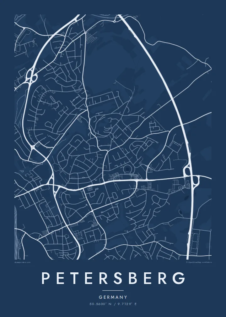
Petersberg is named after its hill. On the map, the hill is the calm centre, with an old church at the top and roads curving around its slopes, while newer residential streets spread across the lower ground toward Fulda. The town has several districts, so the map shows separate clusters of houses joined by country roads and broken up by fields and small woods.
The church on the summit, the Propsteikirche St. Peter, has an early medieval crypt with some of the oldest surviving wall paintings in Germany, and it has drawn visitors to the hill for centuries. Below it, Petersberg works largely as a residential neighbour to Fulda, and the boundary between the two places is barely visible in the street pattern.
A Petersberg map poster shows how the hill organizes everything around it: the streets that climb toward the summit, the housing estates that settle in below, and the open land that separates the villages. It is a quiet, balanced composition that people who know the area will read at a glance.
Roads loop around the Petersberg itself, leaving the summit fairly empty on the map. That blank space around the old church makes the hill easy to pick out.
To the west, Petersberg's streets run straight into Fulda's without a clear break, which shows how closely the two places have grown together.
Outlying districts appear as separate knots of streets set in fields, linked by winding country roads that give the outer part of the poster a loose rhythm.
Prilagodite ga sebi
Dodajte datum, ime ili vlastiti redak teksta, promijenite stil, veličinu ili orijentaciju.
Besplatni pregled je niske rezolucije s vodenim žigom. Tiskani posteri i HD datoteke renderiraju se u 300 DPI, do 7,200 × 10,800 px, bez vodenog žiga.
Zašto Petersberg
It is a good map for someone who grew up below the hill or walked up to the church on Sundays, and for anyone whose life runs between Petersberg and Fulda. The hilltop sits at the centre, and the frame shows everything around it.
Personalize the title, subtitle and coordinates line, perhaps with a street name or a wedding date, and choose Classic black & white, Noir, Paper, Blueprint or Sand to match the room.
Naručite poster Petersberg| Veličina otiska | Rezolucija | Datoteke |
|---|---|---|
| 30 × 40 cm11.8 × 15.7″ | 3,543 × 4,724 px | PNG · PDF |
| 29.7 × 42 cm (A3)11.7 × 16.5″ | 3,508 × 4,961 px | PNG · PDF |
| 42 × 59.4 cm (A2)16.5 × 23.4″ | 4,961 × 7,016 px | PNG · PDF |
| 45.7 × 61 cm18 × 24″ | 5,400 × 7,200 px | PNG · PDF |
| 50 × 70 cm19.7 × 27.6″ | 5,906 × 8,268 px | PNG · PDF |
| 61 × 91.4 cm24 × 36″ | 7,200 × 10,800 px | PNG · PDF |
Za usporedbu, besplatni pregled širok je 900 px, ima vodeni žig i namijenjen je zaslonima. HD datoteke imaju do 8× veću rezoluciju u svakom smjeru i čisto se tiskaju u punoj veličini postera.
Odaberite stil na vrhu stranice, a zatim Tiskani poster — veličinu i, ako želite, okvir — ili Digitalne HD datoteke. Naplata traje samo jedan korak, a stranica vaše narudžbe ažurira se čim plaćanje prođe.
Tiska se na premium mat papiru 200 g/m² u jednoj od šest veličina, od 30 × 40 cm do 24 × 36″. Tiskani posteri kreću od $39, dostava uključena.
Da. Odaberite okvir od masivnog drveta u crnoj, bijeloj, prirodnoj hrastovoj ili tamnoj boji drveta. Dolazi sa staklom otpornim na lom i spreman je za vješanje. Uokvireni posteri kreću od $99, dostava uključena.
Dostava je besplatna u 60+ zemalja. Svaki poster tiska najbliži od naših partnera za tisak u 30+ zemalja, a obično stiže za 3–7 radnih dana. Status i praćenje pošiljke možete pratiti u odjeljku Moje narudžbe. Za nekoliko zemalja dostava traje 2–5 tjedana, a ako još ne dostavljamo u vašu zemlju, stranica će vas na to upozoriti prije plaćanja.
Pošaljite nam fotografiju u roku od 14 dana od dostave i besplatno ćemo ga ponovno tiskati ili vratiti novac.
Da. U uređivaču na ovoj stranici promijenite naslov, podnaslov i redak s koordinatama u što god želite, te odaberite stil i veličinu. Tiskane, uokvirene i digitalne narudžbe koriste točno vaš dizajn.
Za $9 dobivate 300 DPI PNG i PDF datoteke spremne za tisak u svih šest veličina, bez vodenog žiga, za ispis bilo gdje. Niste sigurni? Prvo preuzmite besplatan pregled s vodenim žigom.
U blizini
