Table Mountain
The mountain appears as a wide unbuilt shape at the heart of the map, with the grid of the City Bowl pressed up against its lower slopes.
Postè kat minimalis · South Africa
33.9258° S / 18.4232° E
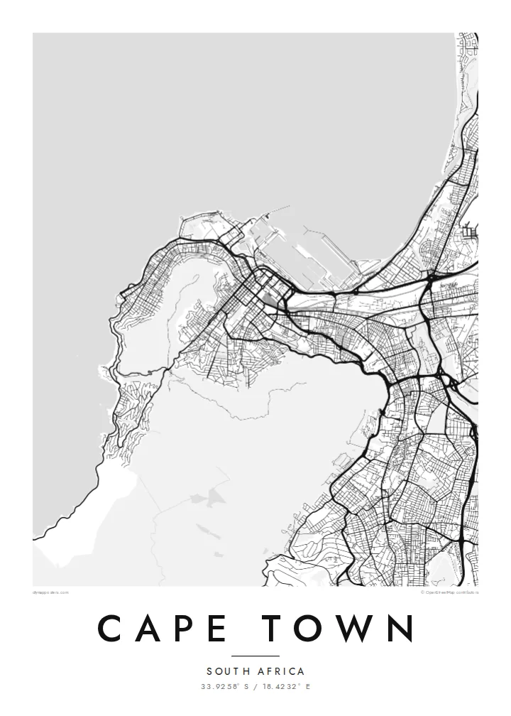
A city wrapped around the foot of Table Mountain, with the Atlantic on one side and Table Bay curving to the north.


Yon vil, senk atmosfè
Peze yon style pou wè li sou mi a. Chak style koute menm pri — enprime, ankadre oswa kòm fichye HD.
 Piksèl reyèl · fichye enpresyon 24 × 36″
Byen klè pou enprime
Sa a se yon zoom 100% sou vrè fichye enpresyon an. Chak afich — enprime, ankadre oswa telechaje — jenere sou sèvè nou yo nan 300 DPI, jiska 7,200 × 10,800 piksèl, konsa menm pi piti wout yo rete klè sou yon enpresyon 24 × 36″.
Sou mi a


Kat la
Cape Town's map is defined as much by what is not built as by what is. Table Mountain and its neighbours, Devil's Peak, Lion's Head and Signal Hill, form a large empty centre around which the city arranges itself. The City Bowl sits in the amphitheatre between them, its streets sloping down toward the harbour and Table Bay.
From there the city spreads in several directions. The Atlantic Seaboard follows a narrow strip of coast west and south of the mountain, while the southern suburbs run along its eastern flank. To the east the broad, sandy Cape Flats open up, with long straight roads laid out across terrain that is almost perfectly level.
Founded in 1652 as a supply station for the Dutch East India Company, the city still keeps the five-pointed Castle of Good Hope near its centre. A Cape Town map poster makes the relationship between mountain and sea unusually clear, since the streets stop wherever the slopes become too steep.
The mountain appears as a wide unbuilt shape at the heart of the map, with the grid of the City Bowl pressed up against its lower slopes.
The harbour basins and breakwaters on Table Bay give the northern edge of the city a sharp, geometric outline of quays and docks.
The seventeenth-century pentagonal fort, with its angled bastions, is one of the most recognisable small shapes in the centre, sitting back from what was once the shoreline.
Fè l pou ou
Ajoute yon dat, yon non oswa pwòp fraz pa w, chanje estil, gwosè oswa oryantasyon.
Apèsi gratis la se nan rezolisyon ba avèk yon watèrmak. Enpresyon ak fichye HD yo jenere nan 300 DPI, jiska 7,200 × 10,800 px, san watèrmak.
Poukisa Cape Town
Cape Town is a place people fall for quickly and remember in detail: a walk up Lion's Head, an apartment in Sea Point, a first view of the bay. A map that shows the mountain as a quiet space at the centre carries that memory without needing a photograph.
Personalise the title and subtitle, add a date or coordinates, and choose from five styles. Blueprint suits the harbour and coastline well, while Classic black & white keeps the mountain outline crisp. Download HD files for $9 or order a printed poster with an optional frame.
Kòmande afich Cape Town a| Gwosè enpresyon | Rezolisyon | Fichye |
|---|---|---|
| 30 × 40 cm11.8 × 15.7″ | 3,543 × 4,724 px | PNG · PDF |
| 29.7 × 42 cm (A3)11.7 × 16.5″ | 3,508 × 4,961 px | PNG · PDF |
| 42 × 59.4 cm (A2)16.5 × 23.4″ | 4,961 × 7,016 px | PNG · PDF |
| 45.7 × 61 cm18 × 24″ | 5,400 × 7,200 px | PNG · PDF |
| 50 × 70 cm19.7 × 27.6″ | 5,906 × 8,268 px | PNG · PDF |
| 61 × 91.4 cm24 × 36″ | 7,200 × 10,800 px | PNG · PDF |
Pou konpare, apèsi gratis la gen 900 px lajè, li gen filigràn epi li fèt pou ekran. Fichye HD yo gen jiska 8 fwa plis rezolisyon nan chak direksyon epi yo enprime pwòp nan gwosè postè konplè.
Chwazi yon style anlè paj la, epi chwazi Afich Enprime — yon gwosè epi, si w vle, yon kad — oswa Fichye Dijital HD. Peman an fèt nan yon sèl etap, epi paj kòmand ou a mete ajou kou peman an konfime.
Li enprime sou papye mat premium 200 gsm nan youn nan sis gwosè, soti nan 30 × 40 cm rive nan 24 × 36″. Afich enprime yo kòmanse nan $39, livrezon enkli.
Wi. Chwazi yon kad an bwa solid nan koulè nwa, blan, chenn natirèl oswa bwa fonse. Li vin ak yon vit ki pa kase epi li pare pou pandye. Afich ankadre yo kòmanse nan $99, livrezon enkli.
Livrezon gratis nan plis pase 60 peyi. Chak afich enprime pa patnè enprimeri ki pi pre w la nan plis pase 30 peyi, e anjeneral li rive nan 3 a 7 jou ouvrab. Ou ka suiv estati a ak swivi kolis la nan Kòmand mwen yo. Kèk peyi pran 2 a 5 semèn, e kote nou poko livre, sit la di w sa anvan w peye.
Voye nou yon foto nan 14 jou apre livrezon an epi nou ap reenprime li gratis oswa remèt ou lajan w.
Wi. Nan editè a sou paj sa a, chanje tit la, soutit la ak liy kowòdone yo pou nenpòt sa w vle, epi chwazi yon style ak yon gwosè. Kòmand enprime, ankadre ak dijital yo tout itilize egzakteman desen w lan.
Pou $9 ou jwenn fichye PNG 300 DPI ak PDF pare-pou-enprime nan tout sis gwosè yo, san watèrmak, pou enprime kote w vle. Pa sèten toujou? Telechaje yon apèsi gratis ak watèrmak anvan.
