Cap de Creus
At the northern end is a knotted peninsula of bare rock, where the coastline splinters into tiny inlets around Cadaqués and Portlligat.
Postè kat minimalis · Spain
41.9254° N / 3.1496° E
A rocky, indented coast of coves and headlands running north from Blanes to the French border at Portbou


Yon vil, senk atmosfè
Peze yon style pou wè li sou mi a. Chak style koute menm pri — enprime, ankadre oswa kòm fichye HD.
 Piksèl reyèl · fichye enpresyon 24 × 36″
Byen klè pou enprime
Sa a se yon zoom 100% sou vrè fichye enpresyon an. Chak afich — enprime, ankadre oswa telechaje — jenere sou sèvè nou yo nan 300 DPI, jiska 7,200 × 10,800 piksèl, konsa menm pi piti wout yo rete klè sou yon enpresyon 24 × 36″.
Sou mi a


Kat la
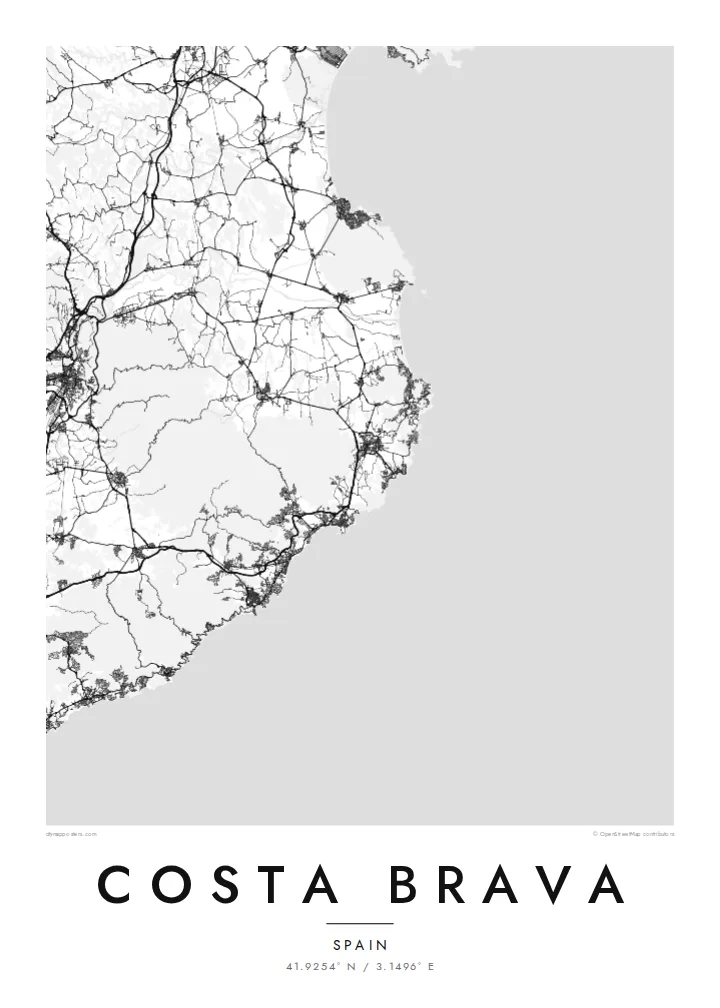
The Costa Brava is the coastline of the province of Girona in Catalonia, running from Blanes in the south to Portbou on the French border. The name means the rugged or wild coast, and it matches what the map shows: a shoreline broken into countless small coves and rocky points, with wider sandy bays, such as the Gulf of Roses, opening between the stretches of cliff.
At the northern end, the Cap de Creus peninsula is the easternmost point of the Iberian Peninsula. Salvador Dalí lived and worked in Portlligat, next to the whitewashed village of Cadaqués. Further south, Tossa de Mar keeps its medieval walled Vila Vella on a headland above the beach, one of the best-preserved fortified old towns on the Catalan coast.
A Costa Brava map poster covers the coast walked by the Camí de Ronda, an old patrol path that now links beaches and coves on foot. Between the resort towns, roads loop up and over the headlands. The wide Gulf of Roses interrupts the rocky shore with a long, gentle curve, backed by the flat wetlands of the Aiguamolls de l'Empordà.
At the northern end is a knotted peninsula of bare rock, where the coastline splinters into tiny inlets around Cadaqués and Portlligat.
A broad, smooth bay between Roses and L'Escala breaks the rocky rhythm of the coast, with the marina canals of Empuriabrava cut into the flat land behind it.
The Vila Vella sits on a small headland, and its enclosed lanes form a compact knot beside the newer, more regular streets of Tossa de Mar.
Fè l pou ou
Ajoute yon dat, yon non oswa pwòp fraz pa w, chanje estil, gwosè oswa oryantasyon.
Apèsi gratis la se nan rezolisyon ba avèk yon watèrmak. Enpresyon ak fichye HD yo jenere nan 300 DPI, jiska 7,200 × 10,800 px, san watèrmak.
Poukisa Costa Brava
For people who go back to the same cove every summer, or who walked the coast path from town to town, this map gives that memory a place on the wall. The title, subtitle and coordinates line can all be changed, so the poster can name a village, a house or a date.
Try Paper or Sand for a sun-warmed look, or Classic black & white, Noir and Blueprint for sharper contrast. The HD files cost $9 and include six print sizes, each as a 300 DPI PNG and a print-ready PDF without a watermark.
Kòmande afich Costa Brava a| Gwosè enpresyon | Rezolisyon | Fichye |
|---|---|---|
| 30 × 40 cm11.8 × 15.7″ | 3,543 × 4,724 px | PNG · PDF |
| 29.7 × 42 cm (A3)11.7 × 16.5″ | 3,508 × 4,961 px | PNG · PDF |
| 42 × 59.4 cm (A2)16.5 × 23.4″ | 4,961 × 7,016 px | PNG · PDF |
| 45.7 × 61 cm18 × 24″ | 5,400 × 7,200 px | PNG · PDF |
| 50 × 70 cm19.7 × 27.6″ | 5,906 × 8,268 px | PNG · PDF |
| 61 × 91.4 cm24 × 36″ | 7,200 × 10,800 px | PNG · PDF |
Pou konpare, apèsi gratis la gen 900 px lajè, li gen filigràn epi li fèt pou ekran. Fichye HD yo gen jiska 8 fwa plis rezolisyon nan chak direksyon epi yo enprime pwòp nan gwosè postè konplè.
Chwazi yon style anlè paj la, epi chwazi Afich Enprime — yon gwosè epi, si w vle, yon kad — oswa Fichye Dijital HD. Peman an fèt nan yon sèl etap, epi paj kòmand ou a mete ajou kou peman an konfime.
Li enprime sou papye mat premium 200 gsm nan youn nan sis gwosè, soti nan 30 × 40 cm rive nan 24 × 36″. Afich enprime yo kòmanse nan $39, livrezon enkli.
Wi. Chwazi yon kad an bwa solid nan koulè nwa, blan, chenn natirèl oswa bwa fonse. Li vin ak yon vit ki pa kase epi li pare pou pandye. Afich ankadre yo kòmanse nan $99, livrezon enkli.
Livrezon gratis nan plis pase 60 peyi. Chak afich enprime pa patnè enprimeri ki pi pre w la nan plis pase 30 peyi, e anjeneral li rive nan 3 a 7 jou ouvrab. Ou ka suiv estati a ak swivi kolis la nan Kòmand mwen yo. Kèk peyi pran 2 a 5 semèn, e kote nou poko livre, sit la di w sa anvan w peye.
Voye nou yon foto nan 14 jou apre livrezon an epi nou ap reenprime li gratis oswa remèt ou lajan w.
Wi. Nan editè a sou paj sa a, chanje tit la, soutit la ak liy kowòdone yo pou nenpòt sa w vle, epi chwazi yon style ak yon gwosè. Kòmand enprime, ankadre ak dijital yo tout itilize egzakteman desen w lan.
Pou $9 ou jwenn fichye PNG 300 DPI ak PDF pare-pou-enprime nan tout sis gwosè yo, san watèrmak, pou enprime kote w vle. Pa sèten toujou? Telechaje yon apèsi gratis ak watèrmak anvan.
